In partnership with: 
|
March 15, 2012 at 7:02 am |
|
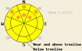
Both above and below treeline, avalanche danger is MODERATE with pockets of CONSIDERABLE danger on NW-N-NE aspects on slopes 35 degrees and steeper. For all other areas, avalanche danger is MODERATE. A trend of increasing avalanche danger is expected tonight and tomorrow. |
|
|
|
New snow amounts above 8,200' for the past 24 hours are 1 to 4 inches with the greatest accumulations occurring along the Sierra Crest north of Echo Summit and in the Mount Rose area. This brings storm totals since Tuesday up to 3 to 24 inches with the northern Sierra Crest heavily favored. Cloud cover, strong winds, and light rain with snowfall above 7,000 to 7,500' will continue today. Remote sensors between 8,200' and 9,650' are reporting air temperatures this morning in the upper 20s to low 30s. Ridgetop winds remain out of the southwest and are strong in speed. Up to 3 inches of additional high density new snow is expected today above 7,500'. Snowfall rates are forecast to increase tonight and continue through Saturday.
Observations made yesterday on Castle Peak (Donner Summit area) revealed several density inversions, also known as upside down layers, within the new snow from the past few days. These inversions were most pronounced in wind protected below treeline areas, but still noticeable in wind affected near and above treeline areas. Limited skier triggered cracking was observed in wind loaded areas with snowpack failure occurring within the upper portion of the storm snow. Snowpit data obtained just above treeline on a wind loaded N aspect at 8,160' revealed that the persistent weak layer of crust and facets that exists on most NW-N-NE aspects was buried nearly 4.5 feet below the snow surface and still displayed sudden collapse properties (pit profile, photo). Recent observations from around the forecast area have shown that fracture propagation along this deeply buried weak layer remains possible.
Today's Primary Avalanche Concern: Wind Slabs and Storm Slabs
Fresh storm slabs and wind slabs have formed over the past few days, last night, and will continue to build today. Cornices are increasing in size and are weak in many areas. Human triggered avalanches occurring within the storm snow are possible to likely today. The greatest areas of danger are expected to exist along the Sierra Crest from Echo summit northward. Significant storm slabs were noted yesterday in wind protected areas below treeline due to density inversions. Some amount of ongoing storm snow instability associated with these weak layers is expected to continue today. In southern and eastern portions of the forecast area where significantly less new snow has accumulated, snowpack instability is expected to remain focused on wind loaded areas.
Today's Secondary Avalanche Concern: Persistent Deep Slabs
The persistent weak layer of crust and facets that exists anywhere from 1 to 5+ feet deep in the snowpack on NW-N-NE aspects is receiving an ever increasing load during this storm cycle. In the highest snowfall areas of the past few days, this weak layer may be too deep for human triggering by a skier or snowmobiler. However, a smaller human triggered avalanche occurring within the storm snow could easily provide the necessary stress on the snowpack to collapse this deeply buried persistent weak layer and trigger a large to very large and destructive slab avalanche. In areas where the persistent weak layer exists within 4 feet of the snow surface, human triggering of this weak layer remains possible.
Today's Tertiary Avalanche Concern: Rain on Snow
Snow levels rose last night up to around 7,000' to 7,500'. This put rain on new snow and may have caused some natural avalanche activity last night below 7,500'. As rain continues to fall on the snowpack today below 7,500', wet loose snow and wet slab avalanches will remain possible. Larger wet slab avalanches could occur if rain water percolates down to the depth of the persistent weak layer on NW-N-NE aspects.
Both above and below treeline, avalanche danger is MODERATE with pockets of CONSIDERABLE danger on NW-N-NE aspects on slopes 35 degrees and steeper. For all other areas, avalanche danger is MODERATE. A trend of increasing avalanche danger is expected tonight and tomorrow.
| 0600 temperature: | 30 to 34 deg. F. |
| Max. temperature in the last 24 hours: | 31 to 37 deg. F. |
| Average wind direction during the last 24 hours: | Southwest |
| Average wind speed during the last 24 hours: | 42 mph |
| Maximum wind gust in the last 24 hours: | 70 mph |
| New snowfall in the last 24 hours: | North of Echo Summit 3 to 4 inches | South of Echo Summit and East of Lake Tahoe 1 to 2 inches |
| Total snow depth: | 29 to 62 inches |
For 7000-8000 ft: |
|||
| Thursday: | Thursday Night: | Friday: | |
| Weather: | Cloudy skies with snow and rain. | Cloudy skies with snow and rain. | Cloudy skies with snow and rain. |
| Temperatures: | 32 to 38 deg. F. | 31 to 36 deg. F. | 31 to 26 deg. F. |
| Wind direction: | SW | SW | SW |
| Wind speed: | 15 to 30 mph with gusts to 50 mph. | 25 to 40 mph with gusts to 60 mph. | 30 to 45 mph with gusts to 65 mph. |
| Expected snowfall: | Above 7,500' near the Sierra Crest up to 3 in. | Above 7,500' near the Sierra Crest up to 6 in. | Near the Sierra Crest up to 9 in. |
For 8000-9000 ft: |
|||
| Thursday: | Thursday Night: | Friday: | |
| Weather: | Cloudy skies with snow. | Cloudy skies with snow. | Cloudy skies with snow. |
| Temperatures: | 28 to 32 deg. F. | 27 to 31 deg. F. | 28 to 32 deg. F. |
| Wind direction: | SW | SW | SW |
| Wind speed: | 30 to 40 mph with gusts to 70 mph. | 55 to 65 mph with gusts to 80 mph. Gusts increasing to 95 mph after midnight. | 50 to 60 mph with gusts to 90 mph. |
| Expected snowfall: | Near the Sierra Crest up to 3 in. | Near the Sierra Crest up to 6 in. | Near the Sierra Crest up to 9 in. |


This website is owned and maintained by the non-profit arm of the Sierra Avalanche Center. Some of the content is updated by the USDA avalanche forecasters including the forecasts and some observational data. The USDA is not responsible for any advertising, fund-raising events/information, or sponsorship information, or other content not related to the forecasts and the data pertaining to the forecasts.

