In partnership with: 
|
March 16, 2012 at 7:00 am |
|
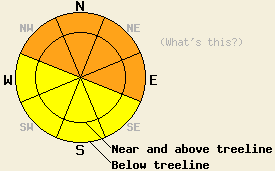
Both above and below treeline, avalanche danger is CONSIDERABLE on NW-N-NE-E aspects on slopes 35 degrees and steeper. For all other areas, avalanche danger is MODERATE. HIGH avalanche danger is expected tonight and tomorrow morning. |
|
|
|
Precipitation intensity increased last night to provide an additional 0.45 to 0.75 inches of water to the forecast area over the past 24 hours. Below 8,000' this mostly fell as rain with 1 to 4 inches of new snow at the higher elevations. Snow water equivalent of anywhere from 1 to 4.5 inches has fallen across the forecast area since Tuesday translating to around 5 to 33 inches of total snowfall with the Sierra Crest north of Echo summit heavily favored for highest precipitation amounts. An additional 1.5 to 4 inches of snow water equivalent is expected over the next 36 hours with most of that precipitation falling tonight and tomorrow morning. Cold front passage is expected to occur late this evening bringing snow level down from 7,500' to 8,000'+ to near 6,000'. Snow level is expected to lower to near 2,500' by tomorrow morning.
This morning, remote sensors between 8,200' and 9,650' are reporting air temperatures at or just below freezing. Air temperatures above 8,000' are forecast to warm slightly today with air temperatures 30 to 35 degrees. Ridgetop winds remain strong out of the southwest this morning and are forecast to continue through tonight before gradually decreasing through the day tomorrow. Maximum daytime air temperatures for tomorrow are expected in the upper teens to upper 20s above 7,000'.
A report of widespread wet loose snow avalanche activity and one wet slab avalanche triggered by rain on new snow early yesterday morning was received from the Donner Pass Road / Old Hwy 40 area. These avalanches occurred on N-NE-E-SE-S aspects below 7,200' (more info). Observations made yesterday on Rubicon Peak (West Shore Tahoe area) and on Becker Peak (Echo Summit area) revealed a significant divergence in overall snowpack depth and subsequent depth of the buried persistent weak layer of crust and facets. On Rubicon Peak, snowpit data obtained near treeline on a N aspect at 8,960' revealed that the persistent weak layer was buried 5.4 feet below the snow surface (pit profile, more info). On Becker Peak, snowpit data obtained near treeline on an E aspect at 8,080' revealed the persistent weak layer was buried 2 feet below the snow surface. Snowpit test on this layer indicated that once collapse of the weak layer was triggered, propagation along that weak layer is likely to occur (video, more info). This indication of likely propagation is similar to recent observations from around the forecast area over the past 2 to 4 weeks. Despite the difference in aspect and elevation of these two areas, the difference in snowpack height has been driven by a significant difference in snowfall accumulation over the last two storm cycles. Snow level was observed yesterday around 8,100' on Rubicon Peak and above at least 8,400' on Becker Peak.
Today's Primary Avalanche Concern: Wind Slabs
Fresh wind slabs will continue to build today in areas that receive new snow, mainly above 8,000'. Cornices are becoming large and are weak in many areas. Human triggered avalanches occurring within the storm snow are possible to today, mainly in wind loaded areas near and above treeline on NW-N-NE-E aspects.
Today's Secondary Avalanche Concern: Persistent Deep Slabs
The persistent weak layer of crust and facets that exists above and below treeline on most NW-N-NE aspects and some E aspects is receiving an ever increasing load of new snow and rain through this storm cycle. Human triggering of this weak layer leading to deep slab avalanches is now of greatest concern along the Sierra Crest from the Echo Summit area southward and along the Carson Range on the east side of Lake Tahoe. In these areas this weak layer is closer to the snow surface and easier to trigger. Along the northern Sierra Crest, this weak layer is now buried 4.5+ feet deep, bridged by a very strong and supportable layer of snow, and very difficult to trigger at this time.
Today's Tertiary Avalanche Concern: Rain on Snow
Rain continues to fall on the snowpack today below 8,000'+ with ongoing wet loose snow and wet slab avalanches possible. Larger wet slab avalanches could occur if rain water percolates down to the depth of and triggers failure of the persistent weak layer of crust and facets on NW-N-NE-E aspects.
Both above and below treeline, avalanche danger is CONSIDERABLE on NW-N-NE-E aspects on slopes 35 degrees and steeper. For all other areas, avalanche danger is MODERATE.
HIGH avalanche danger is expected tonight and tomorrow morning.
| 0600 temperature: | 28 to 32 deg. F. |
| Max. temperature in the last 24 hours: | 32 to 37 deg. F. |
| Average wind direction during the last 24 hours: | Southwest |
| Average wind speed during the last 24 hours: | 49 mph |
| Maximum wind gust in the last 24 hours: | 87 mph |
| New snowfall in the last 24 hours: | 0 to 4 inches |
| Total snow depth: | 30 to 66 inches |
For 7000-8000 ft: |
|||
| Friday: | Friday Night: | Saturday: | |
| Weather: | Cloudy skies with rain and snow. Snow level 7,500 to 8,000'. | Cloudy skies with rain and snow in the early evening. High intensity snowfall through the night. | Cloudy skies with high intensity snowfall in the morning. Snow showers in the afternoon. |
| Temperatures: | 34 to 41 deg. F. | 20 to 25 deg. F. | 22 to 27 deg. F. |
| Wind direction: | SW | SW shifting to W | SW shifting to W |
| Wind speed: | 25 to 35 mph with gusts to 60 mph. | 35 to 45 mph with gusts to 65 mph, shifting and decreasing to 15 to 25 mph with gusts to 45 mph after midnight. | 15 to 25 mph with gusts to 35 mph in the morning, shifting and decreasing to 10 to 20 mph in the afternoon. |
| Expected snowfall: | Above 7,500' to 8,000', 3 to 6 in. | 12 to 24 in. | 8 to 14 in. |
For 8000-9000 ft: |
|||
| Friday: | Friday Night: | Saturday: | |
| Weather: | Cloudy skies with snow. | Cloudy skies with high intensity snowfall. | Cloudy skies with high intensity snowfall in the morning. Snow showers in the afternoon. |
| Temperatures: | 30 to 35 deg. F. | 14 to 20 deg. F. | 18 to 23 deg. F. |
| Wind direction: | SW | SW | SW shifting to W |
| Wind speed: | 50 to 60 mph with gusts to 80 mph. | 50 to 60 mph with gusts to 80 mph. | 30 to 35 mph with gusts to 50 mph, shifting and decreasing to 15 to 20 mph with gusts to 30 mph in the afternoon. |
| Expected snowfall: | 3 to 8 in. | 12 to 24 in. | 8 to 14 in. |


This website is owned and maintained by the non-profit arm of the Sierra Avalanche Center. Some of the content is updated by the USDA avalanche forecasters including the forecasts and some observational data. The USDA is not responsible for any advertising, fund-raising events/information, or sponsorship information, or other content not related to the forecasts and the data pertaining to the forecasts.

