In partnership with: 
|
March 18, 2012 at 7:00 am |
|
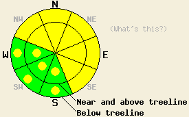
Both above and below treeline, MODERATE avalanche danger remains on NW-N-NE-E-SE aspects on slopes 35 degrees and steeper. For all other areas, avalanche danger is LOW with pockets of MODERATE danger on slopes 35 degrees and steeper. Even though avalanches may be more difficult to trigger today, huge, dangerous deep slab avalanches with serious consequences remain possible today. |
|
|
|
Another four to six inches of snow fell last night bringing snowfall totals since Tuesday to four to six feet above 8000 feet. The heaviest accumulations fell along the Sierra Crest with slightly less east of the Lake. The forecast calls for another burst of snow showers today with accumulations expected to remain light. Temperatures should remain cold today with highs in the teens and 20's above 7000 ft. After this small low pressure wave exits the region a short-lived high pressure ridge should start to form over the area. This ridge should persist through tomorrow and should allow skies to clear and temperatures to warm up slightly. The winds should remain light to moderate in strength, and they shift towards the northeast and northwest by tomorrow.
Widespread large deep slab avalanches occurred on Silver Peak yesterday on NW-N-NE aspects in both above and below treeline terrain. These avalanches released naturally and failed on the persistent weak layer of crusts and weak sugary snow (facets) now buried over six feet deep in many areas. The slides averaged about six feet deep with a maximum depth of ten feet (photos and video). They had propagated around corners and across low angle slopes to create avalanches over 1000 feet wide on one slope. These avalanches likely occured in the predawn hours on March 17th. Skiers reported another similar deep slab avalanche on the north side of Hawk's Peak at about 7500 feet (photos, more info). All of these avalanches occurred on slopes ranging in steepness from 35-45 degrees. Snowpit tests on Silver Peak, on Donner Summit (more info), and on Becker Peak showed that the several weaknesses had existed within the storm snow and that a thick and still wet rain crust remains near the base of the new snow. Data showed that these storm snow weaknesses had already started to settle and consolidate during the day yesterday. On Silver Peak tests on the deeply buried old persistent weak layer still indicated that fractures can easily travel through this layer once it breaks (video and snowpit). Several smaller wind slab and storm slab avalanches also occured on Donner Peak (photos), along the Sierra Crest near Donner Summit (photos), on Tinkers Knob, and on Polson Peak. These slides all occurred on wind loaded N-NE-E aspects in near and above treeline terrain and failed on weaknesses within the storm snow. On Hidden Peak a splitboarder reported collapsing in the upper snowpack and several loose snow sluffs in steep below treeline terrain.
Today's Primary Avalanche Concern: Persistent Deep Slabs
The recent snow and rain have created a strong slab several feet thick on top of the old snowpack. This slab puts the persistent weak layer farther away from the surface making it more difficult for a person recreating on the surface to break it. However, if this layer does break, and tests show that it still can in the right places, huge destructive avalanches will result. These kind of avalanches will remain possible today on NW-N-NE aspects at all elevations. Areas near exposed rock outcrops and cliffs, steep unsupported slopes, slopes with trigger points, and areas where less new snow fell south of Echo Summit and east of the Lake represent locations where the persistent weak layer could remain closer to the surface. In these areas people could put enough force on this layer to initiate a fracture and triggering a deep slab avalanche would be possible. Larger triggers like large cornice failures or other avalanches could also produce these deep slab avalanches today. Caution and conservative decision making remain prudent due to dire the consequences of these kind of avalanches.
Today's Secondary Avalanche Concern: Wind Slabs and Storm Slabs
Due to settlement and consolidation in the storm snow, avalanches resulting from weaknesses within the storm snow should become more difficult to trigger today. Areas where people on top of the snowpack can trigger wind slabs or storm slabs could still exist on NW-N-NE-E-SE aspects on the most heavily wind loaded slopes, on steep unsupported slopes, and in steep complex terrain. Any of these avalanches that occur today could step down and become the deep slab avalanches mentioned above. Some loose snow sluffs may also continue today on steep slopes that have new unconsolidated snow on them.
Both above and below treeline, MODERATE avalanche danger remains on NW-N-NE-E-SE aspects on slopes 35 degrees and steeper. For all other areas, avalanche danger is LOW with pockets of MODERATE danger on slopes 35 degrees and steeper. Even though avalanches may be more difficult to trigger today, huge, dangerous deep slab avalanches with serious consequences remain possible today.
| 0600 temperature: | 12-16 deg. F. |
| Max. temperature in the last 24 hours: | 23-29 deg. F. |
| Average wind direction during the last 24 hours: | Southwest |
| Average wind speed during the last 24 hours: | 10 mph |
| Maximum wind gust in the last 24 hours: | 48 mph |
| New snowfall in the last 24 hours: | 4-7 inches |
| Total snow depth: | 58-96 inches |
For 7000-8000 ft: |
|||
| Sunday: | Sunday Night: | Monday: | |
| Weather: | Cloudy with snow showers | Mostly cloudy with scattered snow showers | Mostly cloudy with a slight chance of snow showers in the afternoon |
| Temperatures: | 20-25 deg. F. | 5-10 deg. F. | 22-29 deg. F. |
| Wind direction: | West shifting to the southwest in the afternoon | West | Variable becoming west in the afternoon |
| Wind speed: | 10-15 mph with gusts to 25 mph increasing to 20-25 mph with gusts to 35 mph in the afternoon | 15-20 mph with gusts to 30 mph decreasing to 5-10 mph overnight | 5-10 mph increasing to 10-15 mph with gusts to 25 mph in the afternoon |
| Expected snowfall: | 1-4 in. | up to 1 in. | O in. |
For 8000-9000 ft: |
|||
| Sunday: | Sunday Night: | Monday: | |
| Weather: | Cloudy with snow showers | Mostly cloudy with scattered snow showers | Mostly cloudy with a slight chance of snow showers in the afternoon |
| Temperatures: | 16-22 deg. F. | 1-8 deg. F. | 17-24 deg. F. |
| Wind direction: | West | West | North-northeast becoming northwest in the afternoon |
| Wind speed: | 15-30 mph with gusts to 40 mph increasing to 50 mph in the afternoon | 20-30 mph with gusts to 45 mph decreasing to 35 mph after midnight | 10-15 mph increasing to 15-25 mph with gusts to 40 mph in the afternoon |
| Expected snowfall: | 1-4 in. | up to 1 in. | O in. |


This website is owned and maintained by the non-profit arm of the Sierra Avalanche Center. Some of the content is updated by the USDA avalanche forecasters including the forecasts and some observational data. The USDA is not responsible for any advertising, fund-raising events/information, or sponsorship information, or other content not related to the forecasts and the data pertaining to the forecasts.

