In partnership with: 
|
March 19, 2012 at 7:00 am |
|
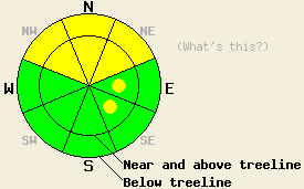
Both above and below treeline, MODERATE avalanche danger remains on NW-N-NE aspects on slopes 35 degrees and steeper. On the E and SE aspects pockets of MODERATE danger exist in near and above treeline terrain on slopes 35 degrees and steeper. Even though avalanches may be more difficult to trigger today, huge, dangerous deep slab avalanches with serious consequences remain possible. |
|
|
|
The small low pressure wave that passed through the region yesterday brought more snow than expected. Two to ten inches of light cold snow fell during the last 24 hours. As this system and the main low pressure system continue to move eastward today, snow showers and cloud cover should decrease allowing slightly warmer daytime highs and some sunshine across the area. Light northwesterly winds should continue today before shifting back to the southwest tonight. By tomorrow a warm front should arrive over the area bringing increased cloud cover, increased southwest winds, a slight chance of snow showers, and daytime highs 10-15 degrees warmer than today.
Several skier-triggered loose sluffs occurred on Hidden Peak (photos, more info) and on Tamarack Peak (more info) yesterday. These sluffs could travel long distances on steep slopes but only entrained the cold light snow on top of the snowpack. Some skier-triggered shooting cracks did occur near and above treeline on Hidden Peak. These cracks happened due to a storm snow weakness failing about 1.5 ft down in the snowpack. Snowpit data in this area still showed that both initiating a fracture and having it propagate along this weakness remained possible. On Tamarack Peak (video), on Waterhouse Peak (video), and below treeline on Hidden Peak (video), snowpit data and observations all indicated that the storm snow continues to settle and consolidate and that the rain layer within the storm snow remains wet, but that it is starting to refreeze. On Tamarack Peak ski cuts and refrigerator-sized cornice blocks dropped on wind-loaded slopes only produced the sluffs mentioned above (photo). Digging deeper into the snowpack reveals that the persistent weak layer of crusts and weak sugary snow (facets) still exits (video from Hidden). It now resides anywhere from five to eight feet down in most places. Tests on this layer on Waterhouse (more info) and on Tamarack Peak (video) still indicated that it remains weak and that fractures can easily travel through this layer if it breaks.
Today's Primary Avalanche Concern: Persistent Deep Slabs
The strong deep slab that now sits above the persistent weak layer makes it more difficult for a person recreating on the surface to send enough force down to this layer to break it. As the upper snowpack continues to strengthen, triggering this layer will become even more difficult. However, if this layer does break, and tests show that it still can in the right places, huge destructive avalanches will result. These kind of avalanches will remain possible today on NW-N-NE aspects at all elevations especially in places where the persistent weak layer remains closer to the surface. Areas near exposed rock outcrops and cliffs, steep unsupported slopes, and slopes with trigger points represent some locations where the persistent weak layer could remain closer to the surface. In these areas it remains possible for people to initiate a fracture that would propagate out into much deeper parts of the snowpack and cause a deep slab avalanche. Larger triggers like large cornice failures or other avalanches could also produce these deep slab avalanches today. Caution and conservative decision making remain prudent due to the dire consequences of these kind of avalanches.
Today's Secondary Avalanche Concern: Wind Slabs and Storm Slabs
Due to settlement and consolidation in the storm snow, avalanches resulting from weaknesses within the storm snow should continue to grow more difficult to trigger today. Areas where people on top of the snowpack can trigger wind slabs or storm slabs may still exist on the most heavily wind-loaded N-NE-E aspects and cross loaded NW and SE aspects in near and above treeline terrain. Steep unsupported slopes and steep complex terrain could also hold some unstable storm snow. Any avalanches that occur today could step down and become the deep slab avalanches mentioned above. Some loose snow sluffs may also continue today on steep slopes that have new unconsolidated snow on them.
Both above and below treeline, MODERATE avalanche danger remains on NW-N-NE aspects on slopes 35 degrees and steeper. On the E and SE aspects pockets of MODERATE danger exist in near and above treeline terrain on slopes 35 degrees and steeper. Even though avalanches may be more difficult to trigger today, huge, dangerous deep slab avalanches with serious consequences remain possible.
| 0600 temperature: | 5-11 deg. F. |
| Max. temperature in the last 24 hours: | 19-26 deg. F. |
| Average wind direction during the last 24 hours: | East of the Lake: North to northeast | Along the Sierra Crest: Southwest |
| Average wind speed during the last 24 hours: | 10-20 mph |
| Maximum wind gust in the last 24 hours: | 47 mph |
| New snowfall in the last 24 hours: | 2-10 inches |
| Total snow depth: | 54-89 inches |
For 7000-8000 ft: |
|||
| Monday: | Monday Night: | Tuesday: | |
| Weather: | Mostly cloudy with a slight chance of snow showers in the afternoon | Cloudy with a slight chance of snow showers in the evening, then a chance of snow after midnight. | Mostly cloudy with a slight chance of snow. |
| Temperatures: | 25-30 deg. F. | 20-25 deg. F. | 38-44 deg. F. |
| Wind direction: | Variable | Variable shifting to the southwest | Southwest |
| Wind speed: | Light | Light increasing to 10-15 mph after midnight | 10-20 mph with gusts to 30 mph |
| Expected snowfall: | O in. | less than 1 in. | less than 1 in. |
For 8000-9000 ft: |
|||
| Monday: | Monday Night: | Tuesday: | |
| Weather: | Mostly cloudy with a slight chance of snow showers in the afternoon | Cloudy with a slight chance of snow showers in the evening, then a chance of snow after midnight. | Mostly cloudy with a slight chance of snow. |
| Temperatures: | 17-25 deg. F. | 18-22 deg. F. | 32-39 deg. F. |
| Wind direction: | Northwest | West | West |
| Wind speed: | 15-20 mph with gusts to 30 mph | 10-15 mph with gusts to 25 mph increasing to 20-30 mph with gusts to 40 mph after midnight | 30-35 mph with gusts to 50 mph decreasing to 20-25 mph with gusts to 40 mph in the afternoon |
| Expected snowfall: | O in. | less than 1 in. | less than 1 in. |


This website is owned and maintained by the non-profit arm of the Sierra Avalanche Center. Some of the content is updated by the USDA avalanche forecasters including the forecasts and some observational data. The USDA is not responsible for any advertising, fund-raising events/information, or sponsorship information, or other content not related to the forecasts and the data pertaining to the forecasts.

