In partnership with: 
|
March 21, 2012 at 6:57 am |
|
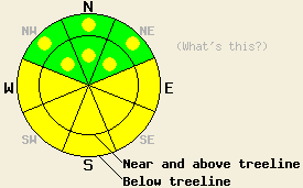
Areas of MODERATE avalanche danger exist on all aspects and at all elevations on slopes 35 degrees and steeper due to a combination of warming instability and ongoing persistent deep slab instability. Large destructive human triggered deep slab avalanches remain possible in isolated areas. Widespread surface wet snow instability is expected again today. |
|
|
|
Today will be warm and sunny as a brief break in the weather occurs ahead of the next weak weather disturbance forecast to arrive over the region tonight. Cloud cover for much of last night has kept air temperatures fairly warm this morning. Air temperatures below 8,000' remain above freezing while air temperatures above 8,000' are at or slightly below freezing. Maximum daytime air temperatures above 7,000' are forecast to reach the upper 30s to near 50 degrees today. Ridgetop winds remain out of the southwest this morning and are expected at moderate in speed today before becoming strong tonight. Light snow showers are expected tonight and tomorrow morning as weather disturbances move back into the forecast area. Slightly colder, but still near to above freezing air temperatures are expected for tomorrow.
Wet surface snow became widespread yesterday with areas of sun, cloud cover, and well above freezing air temperatures affecting snow on all aspects. Light rain was observed along the northern portion of the Sierra Crest from Yuba Pass south at least as far as Donner Summit. Wet snow surface instabilities were reported from a variety of locations including Lincoln Ridge (Yuba Pass area), Cold Stream Canyon (Pole Creek/Deep Creek area), Tamarack Peak (Mount Rose area), and Red Lake Peak (Carson Pass area). Numerous natural and human triggered wet snow avalanches occurred yesterday. Individuals were caught and carried in two separate wet loose snow avalanches yesterday in Cold Stream Canyon and on Red Lake Peak. In both cases the avalanches occurred on N to E aspect terrain on slopes 35 degrees or steeper. Neither avalanche was large enough to bury a person (video, more info). Widespread natural wet loose snow avalanches were observed on all aspects yesterday and in all cases involved only the top several inches of wet snow at the snow surface. Cloud cover for much of last night kept air temperatures above freezing in many mid and low elevation areas. Any significant amount of supportable snow surface refreeze this morning will be limited to areas above 8,000'.
Today's Primary Avalanche Concern: Wet Snow Instability
The combination of a poor snow surface refreeze last night in most areas, strong late March solar radiation, and well above freezing air temperatures will fuel wet surface snow instability again today. Most wet snow instability is expected to occur on E-SE-S-SW-W aspects, but could occur on NW-N-NE aspects as well, especially in areas of sun exposure. Wet loose snow avalanche activity rather than wet slab avalanche activity is expected. Secondary terrain hazards such as cliffs and terrain traps will greatly magnify the consequence of becoming caught and carried in an otherwise small avalanche.
Today's Secondary Avalanche Concern: Persistent Deep Slabs
The persistent weak layer of crusts and facets lurks between five and eight feet deep in the snowpack. In the vast majority of areas this weak layer is buried too deep for a single skier or snowmobiler to transmit force through the snowpack sufficient to collapse and cause propagating failure of the snowpack along this layer. In isolated areas, this weak layer exists within 3 to 4 feet of the snow surface, well within the possibility of human triggering by a skier of snowmobiler. As a result, concerns remain ongoing for isolated deep slab avalanches both above and below treeline on NW-N-NE aspects. Any deep slab avalanches that occur at this time will be large and destructive. Spot probing for this low density snow layer is an effective way to determine the depth of the persistent weak layer in a given location.
Areas of MODERATE avalanche danger exist on all aspects and at all elevations on slopes 35 degrees and steeper due to a combination of warming instability and ongoing persistent deep slab instability. Large destructive human triggered deep slab avalanches remain possible in isolated areas. Widespread surface wet snow instability is expected again today.
| 0600 temperature: | 28 to 34 deg. F. |
| Max. temperature in the last 24 hours: | 33 to 40 deg. F. |
| Average wind direction during the last 24 hours: | Southwest |
| Average wind speed during the last 24 hours: | 19 mph |
| Maximum wind gust in the last 24 hours: | 33 mph |
| New snowfall in the last 24 hours: | O inches |
| Total snow depth: | 47 to 83 inches |
For 7000-8000 ft: |
|||
| Wednesday: | Wednesday Night: | Thursday: | |
| Weather: | Sunny skies. | Mostly cloudy skies with isolated snow showers after midnight. | Mostly cloudy skies becoming partly cloudy. A chance of snow showers, mainly in the morning. |
| Temperatures: | 44 to 50 deg. F. | 30 to 34 deg. F. | 37 to 43 deg. F. |
| Wind direction: | SW | SW | SW |
| Wind speed: | 15 to 25 mph with gusts 35 to 45 mph. | 20 to 35 mph with gusts to 50 mph. | 25 to 35 mph with gusts to 50 mph. |
| Expected snowfall: | O in. | 0 to trace in. | Up to 1 in. |
For 8000-9000 ft: |
|||
| Wednesday: | Wednesday Night: | Thursday: | |
| Weather: | Sunny skies. | Mostly cloudy skies with isolated snow showers after midnight. | Mostly cloudy skies becoming partly cloudy. A chance of snow showers, mainly in the morning. |
| Temperatures: | 36 to 44 deg. F. | 27 to 32 deg. F. | 30 to 38 deg. F. |
| Wind direction: | SW | SW | SW |
| Wind speed: | 20 to 35 mph with gusts to 50 mph. | 40 to 55 mph with gusts to 80 mph. | 40 to 55 mph with gusts to 85 mph. |
| Expected snowfall: | O in. | 0 to trace in. | Up to 1 in. |


This website is owned and maintained by the non-profit arm of the Sierra Avalanche Center. Some of the content is updated by the USDA avalanche forecasters including the forecasts and some observational data. The USDA is not responsible for any advertising, fund-raising events/information, or sponsorship information, or other content not related to the forecasts and the data pertaining to the forecasts.

