In partnership with: 
|
March 25, 2012 at 7:00 am |
|
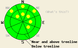
On slopes 35 degrees and steeper, pockets of MODERATE avalanche danger exist both above and below treeline on NW-N-NE aspects and on near and above treeline E-SE aspects due to ongoing persistent deep slab instability and some new shallow wind slabs. Large destructive deep slab avalanches remain possible. For all other areas, avalanche danger is generally LOW. |
|
|
|
The low pressure system off the coast of CA has begun moving inland bringing precipitation and cloud cover with it. This morning the precipitation should reach the Sierra. Since the track of this storm remains more southerly, areas south of Echo Summit should see the most precipitation with three to six inches of snow possible in the next 24 hours. North of Echo summit and east of the Lake the forecast calls for significantly less precipitation with only one to three inches of snowfall. Temperatures should remain cool with high's today and tomorrow in the upper 20's and low 30's above 7000 ft. The winds should shift to the southwest and increase today as the low pressure moves through the area then decrease during the night and remain moderate tomorrow.
Yesterday tests on the persistent weak layer of sugary snow (facets) near old crusts on Incline Lake Peak (video, more info) and in the Deep Creek (videos, more info) area still indicated still that it remains weak and that fractures can easily travel through this layer if it breaks. On Incline Lake Peak four to five feet of strong snow remained on top of this layer making it very difficult for people on the surface to trigger a fracture in the deeply buried layer. In the Deep Creek area at lower elevations, only two to three feet of snow existed on top of this weak layer. In both of these areas a mix of supportable and breakable crusts with a trace of new snow on top existed on snow surface of the northerly aspects. Below this crust in the Deep Creek area recent warming had allowed the entire snowpack to become moist. On the southerly aspects of Incline Lake Peak a frozen melt-freeze crust existed above 8600 ft. Below that elevation about one half to one inch of soft melt-freeze snow had formed on the surface by noon.
Today's Primary Avalanche Concern: Wind Slabs
The new snow and wind forecasted to occur today could create new small wind slabs similar to those that formed on March 23. These shallow slabs should only exist on the most heavily wind loaded N-NE-E aspects and cross-loaded SE aspects in isolated areas in some near and above treeline terrain. Areas south of Echo Summit could see larger wind slabs form due to more snow accumulation. Even though human triggering of these slabs should become possible today, they should not entrain enough snow to bury a person due to their shallowness. These small slides could knock a person off balance or push them into a terrain trap that could magnify the consequences of a small slide.
Today's Secondary Avalanche Concern: Persistent Deep Slabs
Transmitting enough force through the snowpack to trigger a deep slab avalanche remains very difficult due to the depth of the weak layer and the strength of the slab above it. However, if this layer does break, tests indicate that large destructive avalanches with serious consequences could still result. These kind of avalanches will remain possible today on NW-N-NE aspects at all elevations. Areas with a shallow snowpack, areas near exposed rock outcrops and cliffs, steep unsupported slopes, complex terrain features, and slopes with trigger points represent some locations where the persistent weak layer could remain closer to the surface allowing for the possibility that people on the surface could initiate a fracture. That fracture could then propagate out into much deeper parts of the snowpack. Larger triggers like large cornice failures or other avalanches could also produce these deep slab avalanches today.
On slopes 35 degrees and steeper, pockets of MODERATE avalanche danger exist both above and below treeline on NW-N-NE aspects and on near and above treeline E-SE aspects due to ongoing persistent deep slab instability and some new shallow wind slabs. Large destructive deep slab avalanches remain possible. For all other areas, avalanche danger is generally LOW.
| 0600 temperature: | 24-31 deg. F. |
| Max. temperature in the last 24 hours: | 36-45 deg. F. |
| Average wind direction during the last 24 hours: | South |
| Average wind speed during the last 24 hours: | 20-30 mph |
| Maximum wind gust in the last 24 hours: | 45 mph |
| New snowfall in the last 24 hours: | O inches |
| Total snow depth: | 40-78 inches |
For 7000-8000 ft: |
|||
| Sunday: | Sunday Night: | Monday: | |
| Weather: | Cloudy with periods of showers in the morning. Snow showers decreasing in the afternoon. | Cloudy with snow likely. | Mostly cloudy with a chance of snow showers |
| Temperatures: | 31-39 deg. F. | 13-20 deg. F. | 31-39 deg. F. |
| Wind direction: | South | West | Southwest |
| Wind speed: | 15-20 mph with gusts to 35 mph | 10-15 mph with gusts to 25 mph becoming light after midnight | 10-15 mph with gusts to 25 mph |
| Expected snowfall: | North of Echo Summit: up to 3 in. | South of Echo Summit: 2-5 in. | up to 1 in. | O in. |
For 8000-9000 ft: |
|||
| Sunday: | Sunday Night: | Monday: | |
| Weather: | Cloudy with periods of showers in the morning. Snow showers decreasing in the afternoon. | Cloudy with snow likely. | Mostly cloudy with a chance of snow showers |
| Temperatures: | 26-32 deg. F. | 10-17 deg. F. | 27-33 deg. F. |
| Wind direction: | South shifting to southwest in the afternoon | Southwest | Southwest |
| Wind speed: | 40-45 mph with gusts to 65 mph decreasing to 25-30 mph with gusts to 45 mph in the afternoon | 20-25 mph with gusts to 35 mph decreasing to 10-15 mph with gusts to 25 mph after midnight | 20-30 mph with gusts to 45 mph |
| Expected snowfall: | North of Echo Summit: up to 3 in. | South of Echo Summit: 2-5 in. | up to 1 in. | O in. |


This website is owned and maintained by the non-profit arm of the Sierra Avalanche Center. Some of the content is updated by the USDA avalanche forecasters including the forecasts and some observational data. The USDA is not responsible for any advertising, fund-raising events/information, or sponsorship information, or other content not related to the forecasts and the data pertaining to the forecasts.

