In partnership with: 
|
April 1, 2012 at 6:59 am |
|
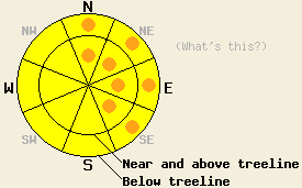
Pockets of CONSIDERABLE avalanche danger exist at all elevations on the N-NE-E-SE aspects on slopes 35 degrees and steeper due to new wind slabs and ongoing deep slab avalanche concerns. MODERATE avalanche danger exists on all other aspects at all elevations. |
|
|
|
Yesterday between noon and midnight, 9-16 inches of snow fell across the forecast area. The Sierra Crest received the most new snow while areas farther east picked up slightly less. The gale force southwest winds accompanying this intense snowfall averaged around 50 mph with gusts over 100 mph. The snow started to taper off, and the winds decreased some after midnight as the cold front continued eastward. Today the forecast calls for the winds to decrease more and shift towards the north behind this front. Snow showers should also come to an end today with little to no accumulation expected. Cold air left in place by the passing cold front should keep daytime highs in the upper 20's and low 30's today and tonight's overnight lows in the teens. A high pressure ridge should begin to form over the region during the next 24 hours allowing warmer temperatures, decreased winds, and decreasing cloud cover for tomorrow.
Yesterday observations on Donner Peak and on Tamarack Peak revealed wet snow underneath a thin refrozen crust layer prior to the start of the storm. On Donner Peak observers reported one small wet slab avalanche on a steep N facing slope at 7000 ft (photo). This slide likely occurred in response to rain on the snowpack. At the higher elevations, 2-6 inches of new snow existed on the snow surface by 1pm. Some skier triggered cracking started to occur in the nascent wind slabs between noon and 1pm. On Tamarack Peak snowfall started around 12:30pm with snowfall rates around 1 inch per hour. In this area tests on the upper snowpack (video) showed a dusting of new snow on top of a strong stable snowpack all the way down to the old persistent weak layer now buried about 4.5 feet deep. A propagation test on this deep weak layer showed that if a fracture starts in this layer it can still propagate along the weak layer (video). This data brings the tally of results on this weak layer since March 18th to 7 non-propagating results and 22 propagating results. Heavy wind loading occurred throughout the afternoon and evening in both of these areas (video).
Today's Primary Avalanche Concern: Wind Slabs
New snow and strong southwest winds caused new fragile wind slabs to form on wind loaded N-NE-E and cross loaded NW and SE aspects over the last 24 hours. These slabs could also exist on more protected slopes due to strong winds at all elevations. As the winds shift to the northwest today, wind slabs on the E-SE aspects should continue to grow in size. Some small new wind slabs may also form on the S aspects. Even though the best window for natural activity likely occurred yesterday evening during the most intense snowfall, human triggering of these slabs will remain likely today. Some natural avalanches may still remain possible in pockets of heavily wind loaded terrain.
Today's Secondary Avalanche Concern: Storm Slabs
In areas where little to no wind affected the light, cold, new snow, it likely has little cohesion and less slab characteristics. In these places expect loose snow sluffs involving the new snow to occur today. Soft storm slabs made of the new snow may also exist on open slopes where either light wind effects or changing conditions during the storm allowed it to form a more cohesive layer. Steep open slopes in below treeline terrain with some wind exposure represent the most likely places for these soft slabs.
Today's Third Avalanche Concern: Persistent Deep Slabs
Old persistent weak layers remain buried in the snowpack. Fortunately, one of them, a more shallowly buried weak layer that would remain easier to trigger, seems limited in its distribution, and a strong snowpack above the other more deeply buried weak layer continues to make it very difficult to trigger fracture in this older deeper layer. Unfortunately, recent snowpit tests still indicate that if these weak layers do break the resulting fracture could propagate along the layer and result in large destructive deep slab avalanches with serious consequences. Even though triggering these kind of avalanches has become unlikely, the possibility of doing so still remains on NW-N-NE aspects at all elevations. Areas where a more shallow snowpack exists like areas near exposed rock outcrops and cliffs, steep unsupported slopes, complex terrain features, and slopes with trigger points represent some locations where the persistent weak layers could remain close enough to the surface for people on the surface break these layers. Larger triggers like large cornice failures, other avalanches (see above), or multiple people on the same slope could also produce these deep slab avalanches.
Pockets of CONSIDERABLE avalanche danger exist at all elevations on the N-NE-E-SE aspects on slopes 35 degrees and steeper due to new wind slabs and ongoing deep slab avalanche concerns. MODERATE avalanche danger exists on all other aspects at all elevations.
| 0600 temperature: | 17-21 deg. F. |
| Max. temperature in the last 24 hours: | 30-34 deg. F. |
| Average wind direction during the last 24 hours: | Southwest |
| Average wind speed during the last 24 hours: | 40-55 mph |
| Maximum wind gust in the last 24 hours: | 108 mph |
| New snowfall in the last 24 hours: | 9-18 inches |
| Total snow depth: | 52-94 inches |
For 7000-8000 ft: |
|||
| Sunday: | Sunday Night: | Monday: | |
| Weather: | Mostly cloudy with scattered snow showers in the morning | Partly cloudy | Partly cloudy becoming mostly cloudy in the afternoon |
| Temperatures: | 31-37 deg. F. | 9-16 deg. F. | 39-46 deg. F. |
| Wind direction: | West shifting to the northwest | Northeast | Southeast |
| Wind speed: | 20-25 mph with gusts to 35 mph decreasing to 10-15 mph in the afternoon | 10-15 mph with gusts to 25 mph after midnight | 15-20 mph with gusts to 30 mph in the morning |
| Expected snowfall: | O in. | O in. | O in. |
For 8000-9000 ft: |
|||
| Sunday: | Sunday Night: | Monday: | |
| Weather: | Mostly cloudy with scattered snow showers in the morning | Partly cloudy | Partly cloudy becoming mostly cloudy in the afternoon |
| Temperatures: | 24-30 deg. F. | 9-16 deg. F. | 34-41 deg. F. |
| Wind direction: | Northwest | Northeast | East |
| Wind speed: | 35-45 mph with gusts to 60 mph decreasing to 20-25 mph with gusts to 40 mph in the afternoon | 15-20 mph with gusts to 30 mph | 20-30 mph with gusts to 45 mph decreasing to 35 mph in the afternoon |
| Expected snowfall: | O in. | O in. | O in. |


This website is owned and maintained by the non-profit arm of the Sierra Avalanche Center. Some of the content is updated by the USDA avalanche forecasters including the forecasts and some observational data. The USDA is not responsible for any advertising, fund-raising events/information, or sponsorship information, or other content not related to the forecasts and the data pertaining to the forecasts.

