In partnership with: 
|
April 4, 2012 at 6:23 am |
|
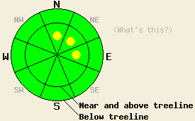
Near and above treeline, avalanche danger is LOW with pockets of MODERATE danger in the most heavily wind loaded areas on N-NE-E aspects on slopes 35 degrees and steeper. For all other areas, avalanche danger is LOW. |
|
|
|
A cold front passed through the forecast area last night and dropped air temperatures well below freezing, deposited 1 to 4 inches of new snow, and created gusty winds that continue this morning. New snow amounts are greatest over the northern half of the forecast area. Remote sensors are reporting air temperatures above 8,000' in the mid to upper teens this morning. Maximum daytime air temperatures above 7,000' are forecast to reach the mid 20s to upper 30s today. Ridgetop winds remain strong in speed out of the southwest this morning and are expected to decrease to moderate in speed this afternoon. A continued cooling trend with snow showers and light to moderate speed winds is forecast for tonight and tomorrow.
Observations made yesterday on Lincoln Ridge (Yuba Pass area) showed that the existing snowpack was in good condition to handle new snow loading. The upper snowpack had stabilized since the last snowfall on Sunday morning (pit profile, more info). Melt freeze conditions existed on all but the most heavily shaded N aspects above 7,400'. This matched well with observations made on Monday on Relay Peak (Mount Rose area) and on Mt. Tallac (Desolation Wilderness area) (more info). Areas of wet snow that existed yesterday aftenoon will have refrozen last night and will remain frozen today.
Today's Avalanche Concern: Wind Slabs
The combination of new snow and strong winds last night is expected to have created new wind slabs in near and above treeline terrain. Areas of unstable wind slabs are expected to have formed mainly in the northern half of the forecast area in the most heavily wind loaded areas on N-NE-E aspects. Slab depth is expected to remain fairly shallow at 1 foot or less.
Deep slab avalanche and persistent weak layer concerns:
At this time, triggering a deep slab avalanche is unlikely. Recent snowpit data indicates that it is still theoretically possible, but the depth of the weak layer and the strength of the overlying slab make it extremely difficult for a skier or snowmobiler to create a sufficient trigger. Since mid February, there has been one main persistent weak layer buried in the snowpack in most areas on NW-N-NE aspects both above and below treeline. This weak layer of old crust and faceted snow crystals is now buried anywhere from 5.5 to 8+ feet deep in the snowpack. While large and destructive avalanches occurred on this weak layer in early and mid March, the current relationship between the depth of the weak layer and the strength of the overlying slab has greatly reduced the chances of deep slab avalanche activity at this time.
Near and above treeline, avalanche danger is LOW with pockets of MODERATE danger in the most heavily wind loaded areas on N-NE-E aspects on slopes 35 degrees and steeper. For all other areas, avalanche danger is LOW.
| 0600 temperature: | 14 to 20 deg. F. |
| Max. temperature in the last 24 hours: | 37 to 49 deg. F. |
| Average wind direction during the last 24 hours: | Southwest |
| Average wind speed during the last 24 hours: | 50 mph |
| Maximum wind gust in the last 24 hours: | 83 mph |
| New snowfall in the last 24 hours: | 2 to 4 inches |
| Total snow depth: | 50 to 91 inches |
For 7000-8000 ft: |
|||
| Wednesday: | Wednesday Night: | Thursday: | |
| Weather: | Partly cloudy skies. Isolated snow showers in the morning. | Mostly cloudy skies with isolated snow showers. | Mostly cloudy skies with isolated snow showers in the morning. Scattered snow showers in the afternoon. |
| Temperatures: | 30 to 38 deg. F. | 6 to 13 deg. F. | 23 to 31 deg. F. |
| Wind direction: | SW | W | W |
| Wind speed: | 30 to 40 mph with gusts to 60 mph, decreasing to 20 to 25 mph with gusts to 40 mph in the afternoon. | 20 to 25 mph with gusts to 40 mph, decreasing to 10 to 15 mph after midnight. | 15 to 20 mph. Gusts up to 30 mph in the afternoon. |
| Expected snowfall: | 0 to trace in. | 0 to trace in. | 0 to trace in. |
For 8000-9000 ft: |
|||
| Wednesday: | Wednesday Night: | Thursday: | |
| Weather: | Partly cloudy skies. Isolated snow showers in the morning. | Mostly cloudy skies with isolated snow showers. | Mostly cloudy skies with isolated snow showers in the morning. Scattered snow showers in the afternoon. |
| Temperatures: | 24 to 32 deg. F. | 2 to 9 deg. F. | 18 to 26 deg. F. |
| Wind direction: | SW | SW shifting to W | W |
| Wind speed: | 50 to 60 mph with gusts to 80 mph, decreasing to 25 to 35 mph with gusts to 55 mph in the afternoon. | 30 to 40 mph with gusts to 60 mph, shifting and decreasing to 15 to 20 mph with gusts to 35 mph after midnight. | 15 to 25 mph with gusts to 35 mph. |
| Expected snowfall: | 0 to trace in. | 0 to trace in. | 0 to trace in. |


This website is owned and maintained by the non-profit arm of the Sierra Avalanche Center. Some of the content is updated by the USDA avalanche forecasters including the forecasts and some observational data. The USDA is not responsible for any advertising, fund-raising events/information, or sponsorship information, or other content not related to the forecasts and the data pertaining to the forecasts.

