In partnership with: 
|
April 6, 2012 at 6:59 am |
|
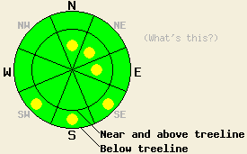
Very isolated pockets of MODERATE avalanche danger may still remain in the most heavily wind loaded areas on N-NE-E aspects on slopes 35 degrees and steeper in near and above treeline terrain. Isolated pockets of MODERATE danger may also form near and below treeline today on SE-S-SW aspects on slopes steeper than 35 degrees with significant sun-exposure. For all other areas, avalanche danger is LOW. |
|
|
|
A high pressure ridge building over the forecast area should bring mostly sunny and dry weather to the region for the next several days. Winds should remain light to moderate out of the west today before shifting to the south by tomorrow. Daytime highs should start to climb today with the forecast calling for temperatures between 7000 and 8000 ft in the upper 30's and low 40's. Above 8000 ft daytime highs could reach into the low to mid 30's. Tomorrow these temperatures should climb another 10 degrees.
Yesterday on Rubicon Peak, two to four inches of cold soft snow existed on the surface of the northerly aspects. On the most shaded and sheltered N-facing aspects above 7600 ft, more soft snow existed under this new snow instead of crusts in many areas. The crusts that did exist under this new snow on the N-facing slopes remained thin and easily breakable. On other aspects and on all aspects below 7600 ft, a much stronger crust existed with less new snow on top of it and "dust on crust" conditions predominated. In wind scoured areas a frozen melt-freeze crust existed on the surface. Ski cuts on steep test slopes did no reveal any signs of instability in this area. Snowpit tests indicated that some of the weaknesses that formed during the recent storm (like grauple layers) do still exist in the upper snowpack; however, fractures traveling along these layers has become unlikely (video).
Today's Primary Avalanche Concern: Wet Snow
The strong April sunshine and daytime highs above freezing could allow enough melting to occur in the snowpack for some wet snow instabilities to form on the most sun-exposed SE-S-SW aspects. The majority of the wet snow instabilities that form today should remain small and limited to surface instabilities like roller balls, pinwheels and some loose wet snow sluffs. If temperatures climb higher than forecasted, these kinds of instabilities could become larger and more widespread.
Today's Secondary Avalanche Concern: Wind Slabs
A few of the shallow wind slabs that exist on the most heavily wind loaded N-NE-E aspects in near and above treeline terrain may still remain sensitive today. Very isolated pockets of terrain where human-triggering of these slabs remains possible may still exist on unsupported slopes and complex or extreme terrain where wind loading has occurred.
Deep slab avalanche and persistent weak layer concerns:
Due to the depth (5 to 8 ft down) of the persistent weak layer on the NW-N-NE aspects and the strength of the snow above it, triggering a deep slab avalanche has become unlikely. Even the avalanche cycle that occurred on April 1st did not add enough force to the snowpack to break through the strong snow on top of the persistent weak layer. At this time data indicates breaking this layer would require an extremely large trigger or significant weakening of the snowpack for these avalanches to begin occurring again in almost all of the areas where this layer exists.
Very isolated pockets of MODERATE avalanche danger may still remain in the most heavily wind loaded areas on N-NE-E aspects on slopes 35 degrees and steeper in near and above treeline terrain. Isolated pockets of MODERATE danger may also form near and below treeline today on SE-S-SW aspects on slopes steeper than 35 degrees with significant sun-exposure. For all other areas, avalanche danger is LOW.
| 0600 temperature: | 3-14 deg. F. |
| Max. temperature in the last 24 hours: | 17-25 deg. F. |
| Average wind direction during the last 24 hours: | West |
| Average wind speed during the last 24 hours: | 10-15 mph |
| Maximum wind gust in the last 24 hours: | 54 mph |
| New snowfall in the last 24 hours: | Trace to 2 inches |
| Total snow depth: | 44-89 inches |
For 7000-8000 ft: |
|||
| Friday: | Friday Night: | Saturday: | |
| Weather: | Sunny | Partly cloudy | Mostly sunny |
| Temperatures: | 33-42 deg. F. | 18-28 deg. F. | 43-50 deg. F. |
| Wind direction: | West | Southwest shifting to the southeast after midnight | South |
| Wind speed: | 10-15 mph with gusts to 25 mph | 10-15 mph with gusts to 25 mph | 15-20 mph with gusts to 30 mph |
| Expected snowfall: | O in. | O in. | O in. |
For 8000-9000 ft: |
|||
| Friday: | Friday Night: | Saturday: | |
| Weather: | Sunny | Partly cloudy | Mostly sunny |
| Temperatures: | 26-37 deg. F. | 15-25 deg. F. | 39-45 deg. F. |
| Wind direction: | Southwest | South | South |
| Wind speed: | 15-25 mph with gusts to 35 mph | 15-25 mph with gusts to 35 mph | 20-30 mph with gusts to 45 mph |
| Expected snowfall: | O in. | O in. | O in. |


This website is owned and maintained by the non-profit arm of the Sierra Avalanche Center. Some of the content is updated by the USDA avalanche forecasters including the forecasts and some observational data. The USDA is not responsible for any advertising, fund-raising events/information, or sponsorship information, or other content not related to the forecasts and the data pertaining to the forecasts.

