In partnership with: 
|
April 7, 2012 at 6:52 am |
|
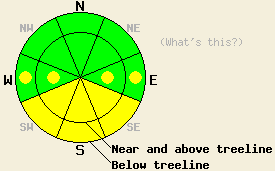
On slopes steeper than 35 degrees, MODERATE avalanche danger may form today on SE-S-SW aspects with pockets of MODERATE danger on the E and W aspects due to daytime warming. For all other areas, avalanche danger is LOW. |
|
|
|
The forecast calls for daytime highs today 5-10 degrees above yesterday's warmest temperatures and clear mostly sunny skies. Above 7000 ft these highs could reach into the upper 40's and low 50's. This warmer weather should continue through the weekend due to a high pressure ridge over the region. Tomorrow skies could become partly cloudy due to a low pressure north and east of the area. The winds should remain light to moderate out of the south and southwest through tomorrow as well.
3-5 inches of soft snow existed on the surface of the N-NE aspects on Donner Peak yesterday. In most areas a supportable crust rests underneath this softer snow. On the most sheltered and shaded N aspects, this crust becomes much less noticeable and even non-existent in some places. Large cornices remained perched above many wind loaded slopes. In these wind loaded areas, 4-12 inches of softer snow existed on the snow surface. Ski cuts on steep wind loaded test slopes did not produce any cracking or slope failures. Some minor sluffing did result on some of the test slopes as the soft new snow slid off of the crust below it. Snowpit tests on a steep wind loaded test slope did show that some of the weaknesses that formed during the storm can still break; however, these tests also indicated that a fracture traveling along these weaknesses and producing an avalanche has become unlikely (video). On the southerly aspects below 7600 ft, 2-3 inches of soft wet snow existed on top of a strong melt-freeze layer by 3 pm (photo). No signs of wet snow instability were observed in this area yesterday.
Today's Primary Avalanche Concern: Wet Snow
The strong April sunshine and daytime highs well above freezing should allow enough melting to occur in the snowpack for wet snow instabilities to form on the sun-exposed E-SE-S-SW-W aspects. Most of these instabilities should manifest themselves as roller balls, pinwheels and wet loose point release slides. In the most sun exposed areas some larger wet snow instabilities like wet slab avalanches may become possible.
Other things to think about: The Persistent weak layer and lingering Wind Slabs:
Due to the depth (5 to 8 ft down) of the persistent weak layer on the NW-N-NE aspects and the strength of the snow above it, triggering a deep slab avalanche has become unlikely. At this time data indicates breaking this layer would require an extremely large trigger or significant weakening of the snowpack for these avalanches to begin occurring again in almost all of the areas where this layer exists.
As for linger wind slabs, enough settlement and consolidation has occurred since the last wind loading event to make triggering a wind slab avalanche unlikely. Unlikely does not mean impossible and some small pockets of instability may still linger on very isolated terrain features on unsupported slopes and in complex or extreme terrain.
On slopes steeper than 35 degrees, MODERATE avalanche danger may form today on SE-S-SW aspects with pockets of MODERATE danger on the E and W aspects due to daytime warming. For all other areas, avalanche danger is LOW.
| 0600 temperature: | 22-32 deg. F. |
| Max. temperature in the last 24 hours: | 33-39 deg. F. |
| Average wind direction during the last 24 hours: | South to Southwest |
| Average wind speed during the last 24 hours: | 10-20 mph |
| Maximum wind gust in the last 24 hours: | 45 mph |
| New snowfall in the last 24 hours: | O inches |
| Total snow depth: | 43-87 inches |
For 7000-8000 ft: |
|||
| Saturday: | Saturday Night: | Sunday: | |
| Weather: | Mostly sunny | Clear | Sunny becoming partly cloudy later in the day |
| Temperatures: | 44-50 deg. F. | 30-40 deg. F. | 47-53 deg. F. |
| Wind direction: | South | Southwest | South |
| Wind speed: | 15-20 mph with gusts to 30 mph | 15-20 mph with gusts to 30 mph becoming light after midnight | Light winds becoming 20-25 mph with gusts to 35 mph in the afternoon |
| Expected snowfall: | O in. | O in. | O in. |
For 8000-9000 ft: |
|||
| Saturday: | Saturday Night: | Sunday: | |
| Weather: | Mostly sunny | Clear | Sunny becoming partly cloudy later in the day |
| Temperatures: | 38-46 deg. F. | 20-27 deg. F. | 42-48 deg. F. |
| Wind direction: | South | Southwest | South |
| Wind speed: | 25-35 mph with gusts to 50 mph | 20-30 mph with gusts to 45 mph | 20-30 mph with gusts to 45 mph |
| Expected snowfall: | O in. | O in. | O in. |


This website is owned and maintained by the non-profit arm of the Sierra Avalanche Center. Some of the content is updated by the USDA avalanche forecasters including the forecasts and some observational data. The USDA is not responsible for any advertising, fund-raising events/information, or sponsorship information, or other content not related to the forecasts and the data pertaining to the forecasts.

