In partnership with: 
|
April 9, 2012 at 6:53 am |
|
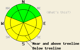
Early this morning, avalanche danger is LOW for all elevations and aspects. MODERATE avalanche danger will develop in response to daytime warming on E-SE-S-SW-W aspects at all elevations on slopes 35 degrees and steeper. |
|
|
|
One more day of sunny skies with well above freezing air temperatures is forecast for today ahead of transitional weather for tomorrow. For today, expect some thin high cloud cover that will not drastically inhibit daytime warming. Remote sensors are reporting air temperatures above 8,000' in the mid to upper 30s this morning. Maximum daytime air temperatures above 7,000' are forecast to reach the mid 40s to upper 50s today. Ridgetop winds remain out of the south to southwest and are light to moderate in speed. Moderate speed winds over the upper elevation ridgetops are forecast for today. Increasing winds, decreasing air temperatures, and a chance of snow showers is forecast for tomorrow.
Observations made yesterday on Incline Lake Peak (Mount Rose area) and on Becker Peak (Echo Summit area) revealed some wet snow instability in areas of direct sun exposure. On Incline Lake Peak ski penetration remained just under ankle deep on solar aspects during the late afternoon hours at the peak of daytime heating. Easily initiated small wet loose human triggered avalanches occurred on moderately steep terrain. Snowpit data collected on N and NE aspects in both areas indicated stable snowpack conditions. On northerly aspects, surface melt freeze crusts were noted in most but not all areas (pit profiles, more info).
Today's Primary Avalanche Concern: Wet Snow
Despite near to above freezing air temperatures last night, mostly clear skies will have allowed for a strong snow surface refreeze this morning. April levels of solar radiation, clear skies this morning, and daytime highs well above freezing will allow for wet snow instabilities to form on E-SE-S-SW-W aspects as the day progresses. Most areas of instability are expected in the form of human triggered roller balls, pinwheels and shallow wet loose snow avalanches. Some amount of wet surface snow will also form on sun exposed NW-N-NE aspects given the high sun angle this time of year.
Other things to think about: The Persistent weak layer:
Deep slab avalanches failing on the old crust and faceted snow weak layer on NW-N-NE aspects has become unlikely at this time. Due to the depth (5 to 8 ft down) of the persistent weak layer and the strength of the snow above it, triggering a deep slab avalanche would require an extremely large trigger. Significant weakening of the snowpack through melting is also something to keep an eye on. Free water is still weeks to months away from reaching this weak layer in most areas, but could eventually allow for a deep wet slab avalanche cycle to occur later this spring.
Early this morning, avalanche danger is LOW for all elevations and aspects. MODERATE avalanche danger will develop in response to daytime warming on E-SE-S-SW-W aspects at all elevations on slopes 35 degrees and steeper.
| 0600 temperature: | 33 to 38 deg. F. |
| Max. temperature in the last 24 hours: | 43 to 50 deg. F. |
| Average wind direction during the last 24 hours: | South - Southwest |
| Average wind speed during the last 24 hours: | 19 mph |
| Maximum wind gust in the last 24 hours: | 35 mph |
| New snowfall in the last 24 hours: | O inches |
| Total snow depth: | 43 to 85 inches |
For 7000-8000 ft: |
|||
| Monday: | Monday Night: | Tuesday: | |
| Weather: | Sunny skies with thin high clouds. | Partly cloudy skies. | Mostly cloudy skies with a chance of snow showers in the afternoon. |
| Temperatures: | 50 to 58 deg. F. | 30 to 36 deg. F. | 40 to 48 deg. F. |
| Wind direction: | S | SW | S |
| Wind speed: | 15 to 25 mph with gusts to 35 mph. | 15 to 25 mph with gusts to 40 mph. | 20 to 30 mph with gusts to 40 mph. |
| Expected snowfall: | O in. | O in. | 0 to trace in. |
For 8000-9000 ft: |
|||
| Monday: | Monday Night: | Tuesday: | |
| Weather: | Sunny skies with thin high clouds. | Partly cloudy skies. | Mostly cloudy skies with a chance of snow showers in the afternoon. |
| Temperatures: | 45 to 50 deg. F. | 31 to 39 deg. F. | 32 to 40 deg. F. |
| Wind direction: | S | S | S |
| Wind speed: | 25 to 35 mph with gusts to 50 mph. | 30 to 40 mph with gusts to 50 mph. Gusts increasing to 60 mph after midnight. | 35 to 45 mph with gusts to 70 mph. |
| Expected snowfall: | O in. | O in. | 0 to trace in. |


This website is owned and maintained by the non-profit arm of the Sierra Avalanche Center. Some of the content is updated by the USDA avalanche forecasters including the forecasts and some observational data. The USDA is not responsible for any advertising, fund-raising events/information, or sponsorship information, or other content not related to the forecasts and the data pertaining to the forecasts.

