In partnership with: 
|
April 10, 2012 at 6:41 am |
|
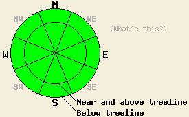
Avalanche danger is LOW for all elevations and aspects. Normal caution is advised. |
|
|
|
Transitional weather will occur today as a weather system approaches the forecast area. Sunny skies this morning are expected to give way to increasing cloud cover and a slight chance of snow showers this afternoon. Thunderstorms are possible this evening. Remote sensors are reporting air temperatures above 8,000' in the low to upper 30s this morning. Maximum daytime air temperatures above 7,000' are forecast to reach the mid 30s to upper 40s today, about 10 degrees cooler than yesterday. Ridgetop winds shifted from south southwest to south last night and are moderate in speed. Stronger winds are starting to show on remote sensors along the Carson Range this morning. Moderate to strong winds are forecast to continue through this evening. An inch or two of new snowfall is expected tonight with a few more inches possible tomorrow. Maximum daytime air temperatures for tomorrow will remain near to below freezing.
Observations made yesterday on Silver Peak (Pole Creek area) revealed wet snow instability forming below 7,700' by noon on SE and E aspects. Snowpit data collected near the summit in above treeline terrain at 8,360' on a ENE aspect indicated that the new snow from last week had not fully transitioned to melt freeze snow on aspects with any amount of northerly component to them in this area (video, pit profile, more info). On northerly aspects, surface melt freeze crusts were noted in most but not all areas with pockets of higher density but still unconsolidated snow in heavily shaded areas.
Today's Primary Avalanche Concern: Wet Snow
Despite near to above freezing air temperatures last night, mostly clear skies will have allowed for a strong snow surface refreeze this morning through radiational cooling. April levels of solar radiation, sunny skies this morning, and air temperatures above freezing will allow for wet snow to form on E-SE-S-SW-W aspects as the day progresses. With increasing cloud cover this afternoon and maximum daytime air temperatures around 10 degrees colder than yesterday, areas of wet snow instability are expected to be much less widespread than over the past few days. Most areas of instability are expected to be fairly isolated and occur in the form of human triggered roller balls, pinwheels and small, shallow wet loose snow avalanches that do not present a significant threat to backcountry travelers. A small amount of wet surface snow may also form on sun exposed NW-N-NE aspects given the high sun angle this time of year.
Other things to think about: The Persistent weak layer:
Deep slab avalanches failing on the old crust and faceted snow weak layer on NW-N-NE aspects has become unlikely at this time. Due to the depth of the persistent weak layer (5 to 8 ft down) and the strength of the snow above it, triggering a deep slab avalanche would require an extremely large trigger. Significant weakening of the snowpack through melting is also something to keep an eye on. Free water is still weeks to months away from reaching this weak layer in most areas, but could eventually allow for a deep wet slab avalanche cycle to occur later this spring.
| 0600 temperature: | 30 to 37 deg. F. |
| Max. temperature in the last 24 hours: | 43 to 51 deg. F. |
| Average wind direction during the last 24 hours: | South - Southwest |
| Average wind speed during the last 24 hours: | 17 mph |
| Maximum wind gust in the last 24 hours: | 31 mph |
| New snowfall in the last 24 hours: | O inches |
| Total snow depth: | 43 to 83 inches |
For 7000-8000 ft: |
|||
| Tuesday: | Tuesday Night: | Wednesday: | |
| Weather: | Mostly cloudy skies with a slight chance of snow showers in the afternoon. | Cloudy skies with isolated thunderstorms in the evening. Snow showers through the night. | Cloudy skies with snow showers. |
| Temperatures: | 40 to 48 deg. F. | 22 to 29 deg. F. | 29 to 35 deg. F. |
| Wind direction: | S | SW | SW |
| Wind speed: | 20 to 30 mph with gusts to 45 mph. | 25 to 30 mph with gusts to 40 mph, decreasing to 15 to 20 mph after midnight. | 15 to 25 mph with gusts to 30 mph. Gusts increasing to 40 mph in the afternoon. |
| Expected snowfall: | 0 to trace in. | 1 to 2 in. | 2 to 3 in. |
For 8000-9000 ft: |
|||
| Tuesday: | Tuesday Night: | Wednesday: | |
| Weather: | Mostly cloudy skies with a slight chance of snow showers in the afternoon. | Cloudy skies with isolated thunderstorms in the evening. Snow showers through the night. | Cloudy skies with snow showers. |
| Temperatures: | 36 to 42 deg. F. | 19 to 26 deg. F. | 20 to 27 deg. F. |
| Wind direction: | S | S shifting to SW | SW |
| Wind speed: | 30 to 40 mph with gusts to 60 mph. | 45 to 50 mph with gusts to 75 mph, shifting and decreasing to 25 to 30 mph with gusts to 50 mph after midnight. | 25 to 30 mph with gusts to 45 mph, increasing to 35 to 40 mph with gusts to 60 mph in the afternoon. |
| Expected snowfall: | 0 to trace in. | 1 to 2 in. | 3 to 5 in. |


This website is owned and maintained by the non-profit arm of the Sierra Avalanche Center. Some of the content is updated by the USDA avalanche forecasters including the forecasts and some observational data. The USDA is not responsible for any advertising, fund-raising events/information, or sponsorship information, or other content not related to the forecasts and the data pertaining to the forecasts.

