In partnership with: 
|
April 11, 2012 at 7:00 am |
|
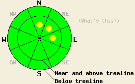
This morning the avalanche danger remains LOW on all aspects and at all elevations. Near and above treeline some pockets of MODERATE avalanche danger may form this afternoon on N-NE-E aspects on slopes steeper than 35 degrees due to new snow and wind loading. The avalanche danger will continue to increase over the next few days as more wind and snow impact the region. |
|
|
|
The low pressure system that was stalled along the CA coast has started to impact the forecast area this morning. Cloud cover and southwest winds increased due to this low pressure system, and light snow showers began around 5 am. These showers should become heavier and should continue through the rest of the day. The forecast calls for 2 to 5 inches of new snow above 7000 ft today. As this first storm exits the region, the snow showers should decrease tonight with only up to 3 inches of accumulation forecasted overnight. A second stronger colder storm should arrive over the area starting Thursday. Southwest winds and snowfall should increase again tomorrow with another 2 to 5 inches expected during the day. This second storm should continue through Friday and could bring another 1 to 2 ft of new snow to the mountains above 7000 ft.
On Jakes Peak yesterday, a mix of wet snow and breakable crusts existed on the snow surface on the northerly aspects at all elevations. Over on Relay Peak above 9000 ft, firm wind scoured surfaces mixed with breakable wind crusts existed on open NW-N-NE aspects with a few patches of softer snow on the most sheltered northerly aspects (photo, video). A mostly stable snowpack existed below these surface conditions in both of these areas yesterday. On Jakes Peak snowpit tests performed on the old persistent weak layer did show that fractures can still travel through this layer; however, data also indicated that it would take a very, very large trigger to break through the slab above this layer (video, photos). Below 9200 ft on Relay Peak and on Jakes Peak, a few inches of soft wet corn snow formed on top of a supportable melt-freeze layer by 11:30 in the morning. No significant wet snow instabilities were observed in either of these areas before noon yesterday.
Today's Primary Avalanche Concern: Wind Slabs
As new snow and wind impact the forecast area today, wind slabs will start to form in wind loaded areas. Due to the light snow accumulations forecasted for today, these slabs should remain small and should quickly dissipate below exposed ridgelines. By this afternoon some pockets of larger human-triggerable wind slabs could form on the most heavily wind loaded slopes on the near and above treeline N-NE-E aspects. Any avalanches that do result from the failure of these wind slabs should remain relatively small; however, they could easily push someone into a terrain trap that would magnify the consequences of the slide.
Other things to think about: The Persistent Weak Layer
Due to the depth (5 to 8 ft down) of the persistent weak layer on the NW-N-NE aspects and the strength of the snow above it, triggering a deep slab avalanche has become unlikely. At this time data indicates breaking this layer would require an extremely large trigger or significant weakening of the snowpack. Spring melting could eventually allow free water to percolate down through the snowpack and cause enough weakening for a deep wet slab avalanche cycle to occur. Conditions that would create enough melting for this scenario remain weeks to months away.
This morning the avalanche danger remains LOW on all aspects and at all elevations. Near and above treeline some pockets of MODERATE avalanche danger may form this afternoon on N-NE-E aspects on slopes steeper than 35 degrees due to new snow and wind loading. The avalanche danger will continue to increase over the next few days as more wind and snow impact the region.
| 0600 temperature: | 24-28 deg. F. |
| Max. temperature in the last 24 hours: | 37-47 deg. F. |
| Average wind direction during the last 24 hours: | Southwest |
| Average wind speed during the last 24 hours: | 25-30 mph |
| Maximum wind gust in the last 24 hours: | 71 mph |
| New snowfall in the last 24 hours: | trace to 1 inches |
| Total snow depth: | 48-82 inches |
For 7000-8000 ft: |
|||
| Wednesday: | Wednesday Night: | Thursday: | |
| Weather: | Cloudy with snow showers | Mostly cloudy with scattered snow showers | Cloudy with snow showers in the morning and more consistent snowfall in the afternoon. |
| Temperatures: | 28-36 deg. F. | 20-25 deg. F. | 27-33 deg. F. |
| Wind direction: | Southwest | Southwest | Southwest |
| Wind speed: | 15-25 mph with gusts to 40 mph | 15-25 mph with gusts to 40 mph | 25-30 mph with gusts to 45 mph increasing to 35-40 mph with gusts to 60 mph in the afternoon |
| Expected snowfall: | 2-4 in. | up to 3 in. | 2-4 in. |
For 8000-9000 ft: |
|||
| Wednesday: | Wednesday Night: | Thursday: | |
| Weather: | Cloudy with snow showers | Mostly cloudy with scattered snow showers | Cloudy with snow showers in the morning and more consistent snowfall in the afternoon. |
| Temperatures: | 21-28 deg. F. | 13-20 deg. F. | 22-27 deg. F. |
| Wind direction: | South shifting to the southwest in the afternoon | Southwest | Southwest |
| Wind speed: | 25-30 mph with gusts to 45 mph increasing to 35-40 mph with gusts to 60 mph in the afternoon | 30-40 mph with gusts to 60 mph | 40-50 mph with gusts to 65 mph increasing to 75 mph in the afternoon |
| Expected snowfall: | 3-5 in. | up to 3 in. | 3-5 in. |


This website is owned and maintained by the non-profit arm of the Sierra Avalanche Center. Some of the content is updated by the USDA avalanche forecasters including the forecasts and some observational data. The USDA is not responsible for any advertising, fund-raising events/information, or sponsorship information, or other content not related to the forecasts and the data pertaining to the forecasts.

