In partnership with: 
|
April 20, 2012 at 6:27 am |
|
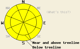
Widespread MODERATE avalanche danger will form quickly today on all aspects at all elevations on slopes 35 degrees and steeper in response to daytime warming. The vast majority of instability that occurs today is likely to be human triggered, but an isolated natural avalanche event is not out of the question. |
|
|
|
Today's weather will be much like yesterday with sunny skies in the morning, well above freezing air temperatures, and light winds. Increasing cumulus cloud build up through the late morning and mid day hours will lead to a slight chance of thunderstorms for this afternoon. This is the fifth morning in a row with air temperatures having remained above freezing overnight. Remote sensors are reporting air temperatures above 8,000' in the upper 30s to mid 40s this morning across the forecast area. Maximum daytime air temperatures above 7,000' are forecast to reach the mid 50s to mid 60s today. Ridgetop winds are out of the east this morning and are light in speed. Light winds are expected to last through this evening. Similar weather is forecast for tomorrow with less cloud build up and no real chance of afternoon thunderstorms.
Observations made yesterday on Tamarack Peak (Mount Rose area) revealed evidence of a decent snow surface refreeze the night before due to radiational cooling. This refreeze affected the top 8 to 12 inches of the snowpack and kept snow surface conditions supportable above 9,000' up until around noon. Skier triggered wet loose snow avalanches were easily triggered on steep ENE and E aspects at 12:30 pm (photos, pit profile, more info). On Castle Peak (Donner Summit area) evidence of minimal to no snow surface refreeze was observed. The overall lower elevation of this area contributed to the lack of a snow surface refreeze. Minor snow surface refreeze was noted above 7,500'. At 7:30 am, ski pen was noted at 2-3 inches in open terrain and up to 4-6 inches in treed terrain (photos, more info).
Today's Primary Avalanche Concern: Wet snow
Clear skies will have allowed for snow surface refreeze to occur last night in many locations despite above freezing air temperatures in all areas. Locations above 8,500' are expected to hold a more significant refreeze than lower elevation areas. Warmer temperatures and clear skies this morning will quickly melt the refreeze that occurred last night. Areas of wet snow instability will form quickly today, especially in areas below 8,000' that may have experienced very little refreeze. Roller balls, wet loose snow avalanches, and wet slab avalanches will all remain possible today. The vast majority of instability that occurs today is likely to be human triggered, but an isolated natural avalanche event is not out of the question. Wet snow avalanches are much more difficult to accurately predict than dry snow avalanches. Uncertainty surrounding the precise timing of wet snow avalanches makes conservative decision making a prudent choice under these conditions. Surface instabilities like roller balls and pinwheels or simple observations like stepping off of one's skis, snowboard, or snowmobile and sinking up to boot-top depth in wet snow can indicate potential instability on a slope.
Other things to think about: The Persistent Weak Layer
Due to the depth of the persistent weak layer and the strength of the snow above it, triggering a deep slab avalanche on NW-N-NE aspects remains unlikely. At this time data indicates collapsing this layer would require an extremely large trigger or significant weakening of the snowpack. Spring melting could eventually cause enough snowpack weakening for a deep wet slab avalanche cycle to occur. Even though data indicates conditions that could create this scenario have not yet arrived, they keep getting closer as more and more melting occurs each day and free water percolates deeper into the snowpack.
Widespread MODERATE avalanche danger will form quickly today on all aspects at all elevations on slopes 35 degrees and steeper in response to daytime warming. The vast majority of instability that occurs today is likely to be human triggered, but an isolated natural avalanche event is not out of the question.
| 0600 temperature: | 39 to 43 deg. F. |
| Max. temperature in the last 24 hours: | 51 to 59 deg. F. |
| Average wind direction during the last 24 hours: | East |
| Average wind speed during the last 24 hours: | 9 mph |
| Maximum wind gust in the last 24 hours: | 26 mph |
| New snowfall in the last 24 hours: | O inches |
| Total snow depth: | 33 to 84 inches |
For 7000-8000 ft: |
|||
| Friday: | Friday Night: | Saturday: | |
| Weather: | Sunny skies in the morning, becoming partly cloudy. A slight chance of thunderstorms in the afternoon. | Partly cloudy skies in the evening, becoming clear. A slight chance of thunderstorms in the evening. | Sunny skies in the morning, becoming partly cloudy. |
| Temperatures: | 60 to 66 deg. F. | 36 to 43 deg. F. | 61 to 67 deg. F. |
| Wind direction: | SE | Variable | Variable |
| Wind speed: | 10 to 15 mph in the morning, becoming light. | Light winds. | Light winds. |
| Expected snowfall: | O in. | O in. | O in. |
For 8000-9000 ft: |
|||
| Friday: | Friday Night: | Saturday: | |
| Weather: | Sunny skies in the morning, becoming partly cloudy. A slight chance of thunderstorms in the afternoon. | Partly cloudy skies in the evening, becoming clear. A slight chance of thunderstorms in the evening. | Sunny skies in the morning, becoming partly cloudy. |
| Temperatures: | 54 to 60 deg. F. | 37 to 44 deg. F. | 56 to 62 deg. F. |
| Wind direction: | E | SW | SE |
| Wind speed: | 10 to 15 mph with gusts to 20 mph in the morning, becoming light. | Light winds becoming 10 to 15 mph after midnight. | Light winds becoming 10 to 15 mph with gusts to 25 mph in the afternoon. |
| Expected snowfall: | O in. | O in. | O in. |


This website is owned and maintained by the non-profit arm of the Sierra Avalanche Center. Some of the content is updated by the USDA avalanche forecasters including the forecasts and some observational data. The USDA is not responsible for any advertising, fund-raising events/information, or sponsorship information, or other content not related to the forecasts and the data pertaining to the forecasts.

