In partnership with: 
|
April 23, 2012 at 6:37 am |
|
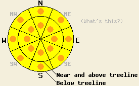
Widespread MODERATE avalanche danger will form quickly today on all aspects at all elevations on slopes 35 degrees and steeper in response to daytime warming. Pockets of CONSIDERABLE danger may form this afternoon on slopes 37 degrees and steeper. The majority of instability that occurs today is likely to be human triggered, but natural avalanches are possible in isolated areas. |
|
|
|
The strong high pressure ridge will keep record setting warm weather over the region again today. Temperatures remained in the upper 40's overnight again last night bringing the number of days without temperatures dropping below freezing to eight in a row. Temperatures should climb into the 60's again today above 7000 ft. As the day warms up some cumulus clouds could start to develop. By this afternoon the forecast calls for a 30% chance of scattered thunderstorms over the area. Starting tonight cooler weather should begin to push into the region with overnight lows forecasted to drop into the upper 30's and low 40's above 7000 ft. By tomorrow daytime highs should only reach into the 50's in the mountains.
The thin frozen crust on the snow surface had already melted in many areas below 8000 ft by 8:30 am yesterday morning. On northerly aspects between 6700 ft and 8000 ft on Donner Peak (photos, more info), melt water had penetrated 8-24 inches deep into the snowpack over the last week (photo). The deeper layers remained cold and dry. Stability tests on the top 3-4 ft of the snowpack showed the potential for continued wet snow instabilities as a result of the melting weakening the snowpack. Ski cuts on steep slopes triggered small wet snow sluffs on NE-N-NW aspects between 8:30 am and 11 am (photo). At 10 am 2-4 inches of corn snow with a supportable base existed on the NW-N aspects yesterday.
Even though air temperatures remained warm last night, the clear skies allowed the snowpack to radiate enough heat out into space for a thin surface refreeze to occur. The combination of very warm air temperatures and the intense April sunshine will cause this thin weak refreeze to melt as soon as the sun hits the slopes today. The melting will add more free water to an already wet snowpack causing the snowpack to lose strength. As the snowpack weakens, wet snow instability will form quickly today on all aspects and at all elevations. Roller balls, wet loose snow avalanches, and wet slab avalanches all remain possible.
Like previous days, human-triggered wet snow instabilities should represent most of today's avalanche activity; however, natural avalanche events will remain possible in isolated areas. Due to uncertainty surrounding the precise timing of wet snow avalanches and the difficulty associated with predicting these instabilities, conservative decision making remains a prudent choice under these conditions. Surface instabilities such as roller balls and pinwheels or simple observations such as stepping off of one's skis, snowboard, or snowmobile and sinking up to boot-top depth or more in wet snow can indicate potential instability on a slope.
Other things to think about: The Persistent Weak Layer
Due to the depth of the persistent weak layer and the strength of the snow above it, triggering a deep slab avalanche on NW-N-NE aspects remains unlikely. At this time data indicates collapsing this layer would require an extremely large trigger or significant weakening of the snowpack. Spring melting could eventually cause enough snowpack weakening for a deep wet slab avalanche cycle to occur. Even though data indicates conditions that could create this scenario have not yet arrived, they keep getting closer as more and more melting occurs each day and free water percolates deeper into the snowpack.
Widespread MODERATE avalanche danger will form quickly today on all aspects at all elevations on slopes 35 degrees and steeper in response to daytime warming. Pockets of CONSIDERABLE danger may form this afternoon on slopes 37 degrees and steeper. The majority of instability that occurs today is likely to be human triggered, but natural avalanches are possible in isolated areas.
| 0600 temperature: | 46-49 deg. F. |
| Max. temperature in the last 24 hours: | 57-64 deg. F. |
| Average wind direction during the last 24 hours: | Southwest |
| Average wind speed during the last 24 hours: | 15-20 mph |
| Maximum wind gust in the last 24 hours: | 46 mph |
| New snowfall in the last 24 hours: | O inches |
| Total snow depth: | 25-76 inches |
For 7000-8000 ft: |
|||
| Monday: | Monday Night: | Tuesday: | |
| Weather: | Mostly sunny becoming mostly cloudy with a 30% chance for scattered thunderstorms in the afternoon | Partly cloudy with a 20% chance of isolated thunderstorms in the evening becoming clear overnight | Mostly cloudy with a 20% chance of thunderstorms in the afternoon |
| Temperatures: | 61-67 deg. F. | 36-43 deg. F. | 52-58 deg. F. |
| Wind direction: | South | Southwest | South |
| Wind speed: | light increasing to 10-20 mph with gusts to 30 mph in the afternoon | 15-20 mph with gusts to 35 mph | Light increasing to 10-15 mph with gusts to 25 mph in the afternoon |
| Expected snowfall: | O in. | O in. | O in. |
For 8000-9000 ft: |
|||
| Monday: | Monday Night: | Tuesday: | |
| Weather: | Mostly sunny becoming mostly cloudy with a 30% chance for scattered thunderstorms in the afternoon | Partly cloudy with a 20% chance of isolated thunderstorms in the evening becoming clear overnight | Mostly cloudy with a 20% chance of thunderstorms in the afternoon |
| Temperatures: | 55-61 deg. F. | 34-41 deg. F. | 46-52 deg. F. |
| Wind direction: | South | Southwest | South |
| Wind speed: | 20-30 mph with gusts to 40 mph | 25-35 mph with gusts to 40 mph | 15-25 mph |
| Expected snowfall: | O in. | O in. | O in. |


This website is owned and maintained by the non-profit arm of the Sierra Avalanche Center. Some of the content is updated by the USDA avalanche forecasters including the forecasts and some observational data. The USDA is not responsible for any advertising, fund-raising events/information, or sponsorship information, or other content not related to the forecasts and the data pertaining to the forecasts.

