In partnership with: 
|
April 26, 2012 at 6:54 am |
|
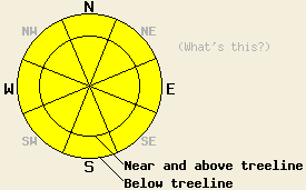
Widespread MODERATE avalanche danger exists on all aspects at all elevations on slopes 32 degrees and steeper due to wet snow instability formed by rain on snow. The vast majority of avalanche activity today is expected to be human triggered, but an isolated natural avalanche is not impossible. |
|
|
|
Precipitation continues to fall across the forecast area early this morning, with intensity expected to decrease as the morning progresses. Snow level has fluctuated between 8,500' and 9,500' last night and remains at that elevation this morning. Precipitation amounts of 0.2 to 0.8 inches of rain and up to 1 inch of snow have fallen over the forecast area in the past 24 hours. Most of the precipitation has been focused along the Sierra Crest from Hwy 88 northward. Lesser amounts have fallen over the Carson Range and over the far southern end of the forecast area. Remote sensors above 8,000' are reporting air temperatures in the mid 30s this morning and have shown a slow cooling trend since around 1 am. Snow level is expected to lower to 5,500' to 6,500' today as colder, drier air moves into the region on the tail end of this weather system. Minimal precipitation is expected during the afternoon hours after the arrival of this colder and drier air. Additional precipitation amounts of 0.2 inches of rain and up to 2 inches of snow are possible today above 7,000'. Strong southwest winds are blowing over this ridgetops today and will continue into the overnight hours. Winds are forecast to decrease to moderate in speed and shift to the north tomorrow. A good overnight refreeze followed tomorrow by partly cloudy skies and maximum daytime air temperatures in the 40s and 50s are expected for tomorrow.
Observations made yesterday on Andesite Ridge (Donner Summit area) indicated that free water production from the melting snowpack had decreased in the area with water draining from the snowpack faster than it was being produced. Most areas held no evidence of overnight snow surface refreeze while a couple of small and isolated areas revealed a refreeze of the top 5 cm of the snow surface from the previous night. At 10am there was around 1 to 2 cm of wet snow on top of this crust in the isolated areas where it existed. At 11:30am ski penetration was limited to 4 cm in areas with no evidence of an overnight refreeze. Ski cuts on steep NE and E aspects produced only small roller balls that broke apart before reaching 30 cm in diameter. A testpit at 8,000' on a NE aspect 30 degree slope at treeline revealed an isothermal snowpack over its full height of 240 cm. All snow layers were either wet grains or rounded polycrystals (photo, more info). Snowpit data collected in this area on March 10th showed that the persistent weak layer had been destroyed by melt freeze (pit profile, more info).
Today's Primary Avalanche Concern: Wet snow
With above freezing air temperatures and rain on snow over nearly all portions of the forecast area, widespread wet snow conditions exist this morning. Significant warming over the past week has established free water drainage channels within the snowpack that should allow for continued drainage of rain and melt water from the snowpack this morning. Areas of surface wet snow instability in the form of human triggered roller balls and wet loose snow avalanches are expected. As the day progresses, air temperatures cool, and precipitation becomes very light, the rate of free water drainage is expected to exceed the rate of free water input and production in the snowpack. This is expected to keep wet snow instability to a minimum during the late afternoon hours, rather different than during the heat wave of this past week.
Today's Secondary Avalanche Concern: Wind slabs
A few isolated pockets of shallow wind slab are possible today above 9,000' in the most heavily wind loaded areas on N-NE-E aspects. Human triggered avalanches are possible in these areas. Slab depth is expected to remain less than 1 foot deep.
Other things to think about: The Persistent Weak Layer
Over the past week, free water has percolated deep into the snowpack and through full height in some areas. While deep wet slab avalanches remain a theoretical concern, so far none have occurred. Limited recent observations on the deeply buried persistent weak layer indicate that free water has not triggered failure of this layer, but was able to percolate through it and destroy it. Given the variability of this weak layer and the uneven depth of free water percolation across the forecast area, deep wet slab avalanches remain an ongoing concern. Unlike dry snow avalanches, deep wet slab avalanches are notoriously difficult to predict and are poorly understood from a research standpoint. Due to an insurmountable lack of information, naturally occurring deep wet slab avalanches cannot be ruled out nor can the most likely timing of occurrence be pinpointed.
Widespread MODERATE avalanche danger exists on all aspects at all elevations on slopes 32 degrees and steeper due to wet snow instability formed by rain on snow. The vast majority of avalanche activity today is expected to be human triggered, but an isolated natural avalanche is not impossible.
| 0600 temperature: | 33 to 34 deg. F. |
| Max. temperature in the last 24 hours: | 38 to 42 deg. F. |
| Average wind direction during the last 24 hours: | Southwest |
| Average wind speed during the last 24 hours: | 33 mph |
| Maximum wind gust in the last 24 hours: | 67 mph |
| New snowfall in the last 24 hours: | Rain 0.2 to 0.8 inches | Snow 1 inches |
| Total snow depth: | 17 to 72 inches |
For 7000-8000 ft: |
|||
| Thursday: | Thursday Night: | Friday: | |
| Weather: | Cloudy skies becoming mostly cloudy in the afternoon. Rain and snow showers in the morning, scattered snow showers in the afternoon. | Partly cloudy skies. Isolated snow showers in the evening. | Partly cloudy skies. |
| Temperatures: | 38 to 44 deg. F. | 24 to 29 deg. F. | 44 to 52 deg. F. |
| Wind direction: | SW | W | NW shifting to NE in the afternoon. |
| Wind speed: | 30 to 40 mph with gusts 55 to 75 mph. | 30 to 35 mph with gusts to 60 mph, decreasing to 10 to 20 mph with gusts to 30 mph after midnight. | 10 to 15 mph with gusts to 30 mph. |
| Expected snowfall: | Up to 2 in. | 0 to trace in. | O in. |
For 8000-9000 ft: |
|||
| Thursday: | Thursday Night: | Friday: | |
| Weather: | Cloudy skies becoming mostly cloudy in the afternoon. Snow showers in the morning, scattered snow showers in the afternoon. | Partly cloudy skies. Isolated snow showers in the evening. | Partly cloudy skies. |
| Temperatures: | 31 to 36 deg. F. | 21 to 26 deg. F. | 40 to 45 deg. F. |
| Wind direction: | SW | W | N |
| Wind speed: | 50 to 60 mph with gusts to 90 mph. | 50 to 55 mph with gusts to 80 mph, decreasing to 30 to 35 mph with gusts to 55 mph after midnight. | 20 to 30 mph with gusts to 45 mph. |
| Expected snowfall: | Up to 2 in. | 0 to trace in. | O in. |


This website is owned and maintained by the non-profit arm of the Sierra Avalanche Center. Some of the content is updated by the USDA avalanche forecasters including the forecasts and some observational data. The USDA is not responsible for any advertising, fund-raising events/information, or sponsorship information, or other content not related to the forecasts and the data pertaining to the forecasts.

