In partnership with: 
|
April 27, 2012 at 6:28 am |
|
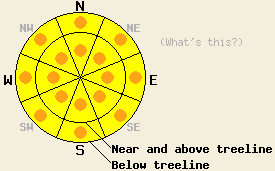
This morning, MODERATE avalanche danger exists near and above treeline in recently wind loaded areas on NW-N-NE-E aspects on slopes 35 degrees and steeper. A transition will occur during the late morning and afternoon hours to warming and wet snow instability. Pockets of CONSIDERABLE avalanche danger are expected to form at all elevations on all aspects on slopes 35 degrees and steeper by this afternoon. |
|
|
|
High pressure is building over the forecast area. The weather system that brought rain and snow to the forecast area from Wednesday afternoon through Thursday evening has departed the region. New snow amounts above 8,000' from the last 36 hours are 2 to 6 inches from 0.6 to 1.4 inches of rain. Cool dry air is in place over the forecast area this morning with remote sensors above 8,000' reporting air temperatures in the mid teens to low 20s. Maximum daytime air temperatures above 7,000' are forecast to reach 40 to 50 degrees today under partly cloudy skies. Strong southwest ridgetop winds from yesterday have decreased to moderate in speed this morning and are shifting to the north. Air temperatures are forecast to drop below freezing again tonight for most locations. Sunny to partly cloudy skies with daytime highs in the mid 40s to upper 50s and light to moderate speed northeast winds are forecast for tomorrow.
Observations made mid day yesterday above 8,600' on Tamarack Peak (Mount Rose area) revealed new snow amounts of 1 to 2 inches existed in wind protected areas and up to 4 inches in wind loaded areas at that time. No evidence of instability was observed in either formal or informal tests. Good bonding was observed at the old/new snow interface. Snowpit data collected at 9,800' on a NE aspect 36 degree slope in near treeline terrain noted free water had only percolated down through the top 2.5 feet of the snowpack. The lower density old persistent weak layer was probed nearly 6.5 feet below the snow surface. At this elevation, free water is still a significant distance away from interacting with the PWL (pit profile, video, more info). Snowpit data collected on Wednesday at 8,000' in similar terrain on a similar aspect on Andesite Ridge (Donner Summit area) indicated that free water had percolated down the the entire depth of the nearly 8 foot deep snowpack (more info).
Today's Primary Avalanche Concern: Wet snow instability
As the strong late April sun warms the snowpack today, widespread wet snow conditions are expected to form. Where several inches of new snow exist, natural and human triggered roller balls, wet loose snow avalanches, and shallow wet slab avalanches are likely to occur. The areas of greatest instability are expected to occur above 8,000' where greater new snow amounts have accumulated. In lower elevation areas that received much more rain than new snow, wet snow instability will form once the overnight refreeze of the snow surface is melted. Significant amounts of wet snow exist under the surface melt freeze crust formed by significant warming and rain over the past week and a lack of a full depth refreeze of the snowpack.
Today's Secondary Avalanche Concern: Wind slabs
Areas of lingering instability associated with wind slabs formed in recently wind loaded areas on NW-N-NE-E aspects will provide for avalanche concerns prior to the onset of warming instability today. Human triggered avalanches are possible in these areas. Most of the wind slabs will be found above 8,000' in areas where the greatest new snow amounts accumulated.
Other things to think about: The Persistent Weak Layer
Over the past week, free water has percolated anywhere from a few feet to full height through the snowpack. While deep wet slab avalanches remain a theoretical concern on NW-N-NE aspects, so far none have occurred. Limited recent observations on the deeply buried persistent weak layer indicate that where free water has reached the depth of the weak layer it did not trigger failure of this layer, but was able to percolate through it and destroy it. Given the variability of this weak layer and the uneven depth of free water percolation across the forecast area, deep wet slab avalanches remain an ongoing concern. Unlike dry snow avalanches, deep wet slab avalanches are notoriously difficult to predict and are poorly understood from a research standpoint. Due to an insurmountable lack of information, naturally occurring deep wet slab avalanches cannot be ruled out nor can the most likely timing of occurrence be pinpointed.
This morning, MODERATE avalanche danger exists near and above treeline in recently wind loaded areas on NW-N-NE-E aspects on slopes 35 degrees and steeper. A transition will occur during the late morning and afternoon hours to warming and wet snow instability. Pockets of CONSIDERABLE avalanche danger are expected to form at all elevations on all aspects on slopes 35 degrees and steeper by this afternoon.
| 0600 temperature: | 19 to 23 deg. F. |
| Max. temperature in the last 24 hours: | 30 to 34 deg. F. |
| Average wind direction during the last 24 hours: | Southwest |
| Average wind speed during the last 24 hours: | 37 mph |
| Maximum wind gust in the last 24 hours: | 79 mph |
| New snowfall in the last 24 hours: | 2 to 5 inches |
| Total snow depth: | 22 to 77 inches |
For 7000-8000 ft: |
|||
| Friday: | Friday Night: | Saturday: | |
| Weather: | Partly cloudy skies. | Partly cloudy skies becoming clear. | Sunny skies becoming partly cloudy. |
| Temperatures: | 44 to 50 deg. F. | 26 to 33 deg. F. | 52 to 58 deg. F. |
| Wind direction: | N | N shifting to E after midnight. | NE |
| Wind speed: | 10 to 15 mph with gusts to 25 mph. | 10 to 15 mph. | 10 to 15 mph in the morning, becoming light. |
| Expected snowfall: | O in. | O in. | O in. |
For 8000-9000 ft: |
|||
| Friday: | Friday Night: | Saturday: | |
| Weather: | Partly cloudy skies. | Partly cloudy skies becoming clear. | Sunny skies becoming partly cloudy. |
| Temperatures: | 39 to 45 deg. F. | 25 to 32 deg. F. | 45 to 51 deg. F. |
| Wind direction: | N | N shifting to NE after midnight. | NE |
| Wind speed: | 20 to 30 mph with gusts to 45 mph. | 20 to 25 mph with gusts to 35 mph, shifting and decreasing to 10 to 15 mph with gusts to 25 mph. | 10 to 20 mph with gusts to 30 mph. |
| Expected snowfall: | O in. | O in. | O in. |


This website is owned and maintained by the non-profit arm of the Sierra Avalanche Center. Some of the content is updated by the USDA avalanche forecasters including the forecasts and some observational data. The USDA is not responsible for any advertising, fund-raising events/information, or sponsorship information, or other content not related to the forecasts and the data pertaining to the forecasts.

