In partnership with: 
|
November 18, 2012 at 7:54 am |
|
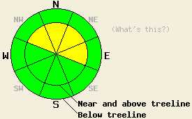
Strong winds and new snowfall have created MODERATE avalanche danger on near and above treeline NW-N-NE-E aspects on slopes steeper than 35 degrees above 7500 ft. Human triggered avalanches are possible in these areas. For all other areas, avalanche danger remains LOW. |
|
|
|
After hovering between 7800 ft. and 8500 ft. for most of the day yesterday, snow levels dropped to around 6500 ft. overnight. The storm deposited another 8-12 inches of wet, dense snow across the forecast area above 8000 ft. Below 8000 ft. most of this precipitation fell as rain. Snow showers should continue in the mountains this morning before tapering off during the day as the storm moves out of the area. A strong low pressure northwest of the region should keep skies cloudy through tomorrow; however, most of the precipitation associated with this system should stay well north of the central Sierra. Expect colder temperatures today and tonight. By tomorrow temperatures should start climbing again. The southwest winds have started to decrease and should continue to diminish over the next 24 hours.
Yesterday on Castle Peak, heavy rain below 8000 ft. caused significant melting of the already shallow snowpack. A few small isolated wet roller balls did occur on steep slopes where snow did remain. Between 8000 ft. and 8500 ft. the precipitation fell as a mix of snow and rain. In this elevation range, observations, ski cuts, and snowpit tests showed good bonding within the new snow and between new snow and the old snow below it (video). Wind slabs up to 3 ft in depth existed in the most heavily wind loaded areas. Above 8500 ft. some small, human-triggered shooting cracks did occur in the wind loaded areas (more information). In the Mt. Rose backcountry, observations show greater instability. Several long human-triggered shooting cracks occurred on N-NE aspects (photo). Snowpit tests revealed weaknesses that broke easily within the new snow. Once a crack started in this weak layer, tests indicated that it could quickly and easily travel through the snowpack (video). In both areas wind loading continued throughout the day (video).
Today's Primary Avalanche Concern: Wind Slabs and Storm Slabs
The wind slabs that formed yesterday continued to grow as more snow and wind impacted the forecast area last night. Wind slabs several feet deep could exist on wind-loaded and cross-loaded NW-N-NE-E aspects above 7500 ft. The largest and most fragile wind slabs will reside on open near and above treeline terrain. The additional weight of a person on top of these slabs could break the bonds holding them in place resulting in human-triggered avalanche activity. The areas where these wind slabs exist also had the most coverage before this storm meaning that the anchors holding the snowpack in place may have already been buried and will not help hold the wind slabs in place. Smaller storm slabs may also exist in in non-wind loaded areas that received more snow than rain during this storm. Human-triggered avalanches involving both these slabs will be possible today.
Strong winds and new snowfall have created MODERATE avalanche danger on near and above treeline NW-N-NE-E aspects on slopes steeper than 35 degrees above 7500 ft. Human triggered avalanches are possible in these areas. For all other areas, avalanche danger remains LOW.
| 0600 temperature: | 26-32 deg. F. |
| Max. temperature in the last 24 hours: | 32-38 deg. F. |
| Average wind direction during the last 24 hours: | Southwest |
| Average wind speed during the last 24 hours: | 45 mph |
| Maximum wind gust in the last 24 hours: | 91 mph |
| New snowfall in the last 24 hours: | 8-12 inches |
| Total snow depth: | 14-36 inches |
For 7000-8000 ft: |
|||
| Sunday: | Sunday Night: | Monday: | |
| Weather: | Snow showers in the morning becoming scattered by mid day. | Isolated snow showers in the evening. | Mostly cloudy |
| Temperatures: | 32-37 deg. F. | 21-26 deg. F. | 37-42 deg. F. |
| Wind direction: | Southwest | Southwest | Southwest |
| Wind speed: | 20-30 mph with gusts to 45 mph | 15-25 mph with gusts to 35 mph | 10-20 mph with gusts to 30 mph |
| Expected snowfall: | up to 3 in. | O in. | O in. |
For 8000-9000 ft: |
|||
| Sunday: | Sunday Night: | Monday: | |
| Weather: | Snow showers in the morning becoming scattered by mid day. | Isolated snow showers in the evening. | Mostly cloudy |
| Temperatures: | 29-34 deg. F. | 20-26 deg. F. | 33-39 deg. F. |
| Wind direction: | Southwest | Southwest | Southwest |
| Wind speed: | 35-45 mph with gusts to 70 mph | 30-40 mph with gusts to 60 mph | 20-30 mph with gusts to 45 mph |
| Expected snowfall: | up to 3 in. | O in. | O in. |


This website is owned and maintained by the non-profit arm of the Sierra Avalanche Center. Some of the content is updated by the USDA avalanche forecasters including the forecasts and some observational data. The USDA is not responsible for any advertising, fund-raising events/information, or sponsorship information, or other content not related to the forecasts and the data pertaining to the forecasts.

