In partnership with: 
|
November 25, 2012 at 7:52 am |
|
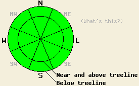
Today the avalanche danger is LOW. LOW danger does not mean no danger. Some unstable snow may still linger on isolated terrain features especially on high elevation NW-N-NE aspects in complex or extreme terrain. Use normal caution when traveling in the backcountry. |
|
|
|
A low pressure system passing north of the region has brought some moderate southwest winds, a few clouds, and cooler temperatures to the forecast area. This morning temperatures range from the upper 20's below 7000 ft to the mid and upper 30's above 8000 ft. The clouds and winds should diminish over the next 24 hours as the high pressure ridge returns to the area bringing back the clear sunny weather. Slightly cooler daytime highs in the low to mid 40's should linger around the region for today and tomorrow.
Yesterday observations on the Fireplug in the Mt. Rose area revealed that weak faceted snow does still exist near the base of the snowpack on the northerly aspects in this area. The strength, thickness, size, and shape of this layer vary greatly from one location to another even over short distances. In this area yesterday, some snowpit tests showed that once this persistent weak layer breaks fractures can still travel through it, while the same test performed next door indicated the opposite. A cohesive slab resides above this layer in many places. Recent observations at higher elevations in the Mt. Rose backcountry have shown small isolated areas where more developed and weaker facets do remain. This layer appears weakest on some small isolated northerly slopes above 9500 ft. that received little to no traffic prior to the most recent snowfall.
On the west side of Lake Tahoe along the Sierra Crest, a shallow but mostly consolidated snowpack exists. In most areas along the Crest, recent observations have shown little to no snow below 7500 ft. Above 8000 ft. more snow coverage exists and the snowpack consists of a a mix of thick crusts and consolidated snow. Recent data from Round Top near Carson Pass did indicate some very isolated lingering instability on a northerly aspect above 9000 ft.
Today's Avalanche Concerns:
Even though LOW avalanche danger exists around the forecast area, it does not mean no danger remains. Some unstable snow may still linger on isolated terrain features especially in high elevation complex or extreme terrain. Small isolated areas where cohesive snow rests on top a persistent weak layer do remain in the in the Mt. Rose backcountry on NW-N-NE aspects above 9500 ft. Variability associated with the existence, location, strength, and coverage of both the persistent weak layer and the possible lingering instability along the Crest make good observations and safe travel techniques a prudent choice. Probing into the snowpack and digging quick snowpits can reveal whether or not these issues exist on a particular slope.
Also, the shallow early season snowpack means more exposed stumps, rocks, trees, and other very hard objects that tend to "win" when they collide with backcountry recreationalists.
Today the avalanche danger is LOW. LOW danger does not mean no danger. Some unstable snow may still linger on isolated terrain features especially on high elevation NW-N-NE aspects in complex or extreme terrain. Use normal caution when traveling in the backcountry.
| 0600 temperature: | 30-37 deg. F. |
| Max. temperature in the last 24 hours: | 44-52 deg. F. |
| Average wind direction during the last 24 hours: | West Southwest |
| Average wind speed during the last 24 hours: | 20-25 mph |
| Maximum wind gust in the last 24 hours: | 50 mph |
| New snowfall in the last 24 hours: | O inches |
| Total snow depth: | 12-28 inches |
For 7000-8000 ft: |
|||
| Sunday: | Sunday Night: | Monday: | |
| Weather: | Partly cloudy this morning becoming sunny during the day. | Clear | Sunny |
| Temperatures: | 41-48 deg. F. | 28-34 deg. F. | 42-49 deg. F. |
| Wind direction: | Southwest | Variable | Variable |
| Wind speed: | 10-15 mph with gusts to 25 mph | Light | Light |
| Expected snowfall: | O in. | O in. | O in. |
For 8000-9000 ft: |
|||
| Sunday: | Sunday Night: | Monday: | |
| Weather: | Partly cloudy this morning becoming sunny during the day. | Clear | Sunny |
| Temperatures: | 39-49 deg. F. | 30-36 deg. F. | 36-43 deg. F. |
| Wind direction: | West | West shifting to the southeast after midnight | Southwest |
| Wind speed: | 15-25 mph with gusts to 35 mph | 10-15 mph with gusts to 25 mph | 15-20 mph with gusts to 30 mph in the afternoon |
| Expected snowfall: | O in. | O in. | O in. |


This website is owned and maintained by the non-profit arm of the Sierra Avalanche Center. Some of the content is updated by the USDA avalanche forecasters including the forecasts and some observational data. The USDA is not responsible for any advertising, fund-raising events/information, or sponsorship information, or other content not related to the forecasts and the data pertaining to the forecasts.

