In partnership with: 
|
November 29, 2012 at 8:00 am |
|
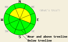
MODERATE avalanche danger exists on near and above treeline NW-N-NE-E aspects steeper than 35 degrees due to new snow, strong winds, and some areas of persistent weak layers. In other areas the avalanche danger should remain LOW. Expect the avalanche danger to increase tonight and continue to rise as a large storm impacts the region over the next few days. |
|
|
|
.5 to 1.2 inches of liquid precipitation fell across the forecast area yesterday. Those areas closest to the Sierra crest received the highest precipitation amounts and areas farther east received the lower end of those amounts. Snow levels mostly stayed near 7000 ft with a brief drop down to 6500 ft during the afternoon. Above 7000 ft. 5-7 inches of new snow accumulated across the mountains. The forecast calls for break in precipitation today. Some showers could continue to produce up to an inch of new snow above 7000 ft. today. The gale force southwest winds that accompanied yesterday's storm will continue today. These winds and precipitation should begin to increase tonight as the second wave of this series of storms arrives over the region. The forecast calls for wind speeds along the Sierra Crest in the 75-90 mph range with gusts over 130 mph for tonight and tomorrow. This wave should also bring another 1-3 inches of liquid to the region tonight and tomorrow. with snow levels between 7000 ft. and 7500 ft. 2-3 ft of wet heavy snow could easily accumulate at the higher elevations. The lower elevations will see a mix of rain and very wet snow. Another even wetter and warmer storm should follow this weekend. For more information check out this weather briefing from the Reno NWS.
Yesterday observations in the Mt. Rose backcountry showed that new wind slabs and small cornices began forming as soon as the snowfall started. By 3 pm some of these wind slabs had already reached 6-8 inches in depth. They did not extend very far away from ridgelines nor had they become very widespread at that time. Skier triggered shooting cracks up to 4 ft in length did occur in the most heavily wind loaded areas (photos more information). In less wind affected areas, observations also showed poor bonding between the new snow and the old snow surfaces of crusts and less consolidated snow. Ski cuts on steep test slopes caused the new snow to easily sluff downhill.
Recent observations across the forecast area prior to yesterday's snowfall revealed a shallow and consolidated snowpack capped by thick firm crusts at the mid elevations, and patchy snow coverage at the lower elevations. Some persistent weak layers have formed in the snowpack at the upper elevations. These weak layers consist of weak sugary snow (facets) that exists below a crust on northerly aspects above 8200 ft along the Sierra Crest and near the base of the snowpack on northerly aspects above 9300 ft in the Mt. Rose area and in the Freel Peak area.
Today's Primary Avalanche Concern: Wind Slabs
Human triggered avalanches involving the wind slabs that formed yesterday will remain possible today. Some of these wind slabs could have grown to a few feet in depth due to the continued strong winds and snowfall. Today's strong winds will continue to move snow and may create new wind slabs in some unexpected places. These wind slabs sit on top of ice crusts and unconsolidated snow in some areas. Yesterday's data indicated that they have not bonded well to these old snow surfaces. The largest and most fragile wind slabs will exist on near and above treeline NW-N-NE-E aspects where the most wind loading has and continues to occur. Some smaller but still fragile wind slabs may exist in more protected areas due to the strength of the winds.
Today's Secondary Avalanche Concern: Persistent Slabs
This problem results from the existence the persistent weak layers in isolated areas above 9,000' on NW-N-NE aspects. These kind of avalanches should remain small and difficult to trigger today and any areas of instability that do exist will be hidden within surrounding areas of stable snow. As more storms arrive and add significant load to the snowpack over the next several days, triggering these kind of avalanches could become easier and this problem could become more widespread.
MODERATE avalanche danger exists on near and above treeline NW-N-NE-E aspects steeper than 35 degrees due to new snow, strong winds, and some areas of persistent weak layers. In other areas the avalanche danger should remain LOW. Expect the avalanche danger to increase tonight and continue to rise as a large storm impacts the region over the next few days.
| 0600 temperature: | 28-32 deg. F. |
| Max. temperature in the last 24 hours: | 32-38 deg. F. |
| Average wind direction during the last 24 hours: | Southwest |
| Average wind speed during the last 24 hours: | 55 mph |
| Maximum wind gust in the last 24 hours: | 105 mph |
| New snowfall in the last 24 hours: | 5-8 inches |
| Total snow depth: | 21-35 inches |
For 7000-8000 ft: |
|||
| Thursday: | Thursday Night: | Friday: | |
| Weather: | Scattered showers | Cloudy with a mix of snow and rain. Snow levels between 7000 ft and 7500 ft. | Cloudy with a mix of snow and rain. Snow levels between 7000 ft and 7500 ft. |
| Temperatures: | 34-41 deg. F. | 27-34 deg. F. | 33-40 deg. F. |
| Wind direction: | Southwest | South | Southwest |
| Wind speed: | 30-45 mph with gusts to 75 mph | 35-50 mph with gusts to 80 mph | 50-65 mph with gusts to 85 mph |
| Expected snowfall: | up to 1 in. | 2-6 in. | 6-10 in. |
For 8000-9000 ft: |
|||
| Thursday: | Thursday Night: | Friday: | |
| Weather: | Scattered snow showers | Snow | Snow |
| Temperatures: | 34-40 deg. F. | 24-31 deg. F. | 32-38 deg. F. |
| Wind direction: | Southwest | Southwest | Southwest |
| Wind speed: | 60-65 mph with gusts to 100 mph increasing to 70-75 mph with gusts to 115 mph in the afternoon | 75-90 mph with gusts to 130 mph | 75-90 mph with gusts to 135 mph |
| Expected snowfall: | up to 1 in. | 4-10 in. | 12-24 in. |


This website is owned and maintained by the non-profit arm of the Sierra Avalanche Center. Some of the content is updated by the USDA avalanche forecasters including the forecasts and some observational data. The USDA is not responsible for any advertising, fund-raising events/information, or sponsorship information, or other content not related to the forecasts and the data pertaining to the forecasts.

