In partnership with: 
|
December 3, 2012 at 7:42 am |
|
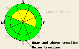
Near and above treeline, avalanche danger is MODERATE on NW-N-NE-E aspects on slopes 35 degrees and steeper due to lingering wind slabs and storm slabs. For all other areas, avalanche danger is LOW. |
|
|
|
A break in the weather will occur today as one storm systems moves out of the area and the next moves in. Yesterday, snow levels lowered much earlier than forecast leading to sharply reduced rainfall amounts and more snow than forecast at the 7,000' level. Ridgetop winds also decreased much quicker than expected. New snow amounts over the past 24 hours were directly tied to elevation. Remote sensors between 6,800' and 8,800' are reporting 6 to 16 inches of new snow. Cloud cover ahead of the next weather system for late Tuesday is already moving into the forecast area. Air temperatures at 8,000' are in the upper 20s to low 30s this morning. Maximum daytime air temperatures at 8,000' are forecast to warm well into the 30s today and possibly into the 40s. Ridgetop winds remain out of the southwest and are light to moderate in speed. Winds are forecast to increase to moderate to strong in speed by tomorrow afternoon. Snow level associated with the next storm is expected to rise above 9,000'.
Observations made yesterday afternoon on Andesite Peak (Donner Summit area) revealed good bonding of new snow to the rain crust at its base. The snowpack is in a state of refreeze after receiving significant rain over the past several days. Snowpit data collected at 8,200' on an E aspect in above treeline terrain indicated that rain affected the top 1.5 feet of the snowpack in that area and at that elevation. Surface wind slabs were prevalent, but difficult to trigger. Several ski cuts on 40 to 45 degree test slopes near the snowpit site did not produced signs of instability within the new snow (pit profile, more info).
Today's Primary Avalanche Concern: Wind Slabs and Storm Slabs
Avalanche concerns for today are focused on lingering instability associated with wind slabs and storm slabs that formed yesterday. Stubborn, difficult to trigger wind slabs are expected in areas that have received significant wind affects. In addition to the obvious above treeline line areas, this includes near treeline areas that are technically below treeline and receive significant wind affects. Lingering instability within the storm snow is also a concern for areas above 8,500' that received 1 to 2 feet of new snow yesterday. The areas of greatest instability for today are expected on NW-N-NE-E aspects. Natural avalanches are unlikely. Human triggered avalanches large enough to bury or injure a person remain possible.
Near and above treeline, avalanche danger is MODERATE on NW-N-NE-E aspects on slopes 35 degrees and steeper due to lingering wind slabs and storm slabs. For all other areas, avalanche danger is LOW.
| 0600 temperature: | 28 to 32 deg. F. |
| Max. temperature in the last 24 hours: | 35 to 37 deg. F. |
| Average wind direction during the last 24 hours: | Southwest |
| Average wind speed during the last 24 hours: | 59 mph |
| Maximum wind gust in the last 24 hours: | 139 mph |
| New snowfall in the last 24 hours: | 6 to 16 inches |
| Total snow depth: | 42 to 59 inches |
For 7000-8000 ft: |
|||
| Monday: | Monday Night: | Tuesday: | |
| Weather: | Mostly cloudy skies. | Mostly cloudy skies with a slight chance of snow after midnight. | Mostly cloudy skies becoming cloudy. A chance of rain and snow showers. Snow level rising above 8,000' by late morning. |
| Temperatures: | 36 to 43 deg. F. | 26 to 33 deg. F. | 40 to 47 deg. F. |
| Wind direction: | SW | SW | SW |
| Wind speed: | 10 to 15 mph with gusts to 25 mph. | 15 to 25 mph with gusts to 30 mph. Gusts increasing to 40 mph after midnight. | 25 to 30 mph with gusts to 50 mph, increasing to 35 to 40 mph with gusts to 60 mph in the afternoon. |
| Expected snowfall: | O in. | 0 to trace in. | 0 to trace in. |
For 8000-9000 ft: |
|||
| Monday: | Monday Night: | Tuesday: | |
| Weather: | Mostly cloudy skies. | Mostly cloudy skies with a slight chance of snow after midnight. | Mostly cloudy skies with a slight chance of rain and snow showers. Snow level rising above 9,000' in the afternoon. |
| Temperatures: | 33 to 40 deg. F. | 24 to 31 deg. F. | 35 to 42 deg. F. |
| Wind direction: | SW | SW | SW |
| Wind speed: | 15 to 25 mph with gusts to 40 mph. | 25 to 35 mph with gusts to 40 mph. Gusts increasing to 50 mph after midnight. | 35 to 45 mph with gusts to 60 mph. Gusts increasing to 70 mph in the afternoon. |
| Expected snowfall: | O in. | O in. | 0 to trace in. |


This website is owned and maintained by the non-profit arm of the Sierra Avalanche Center. Some of the content is updated by the USDA avalanche forecasters including the forecasts and some observational data. The USDA is not responsible for any advertising, fund-raising events/information, or sponsorship information, or other content not related to the forecasts and the data pertaining to the forecasts.

