In partnership with: 
|
December 5, 2012 at 8:00 am |
|
CONSIDERABLE avalanche danger exists on snow-covered slopes steeper than 35 degrees due to a mix of rain on snow, new snow, and wind. Human triggered avalanches are likely today and natural avalanches will be possible. |
|
|
|
North of Hwy 50 1-2 inches of precipitation has fallen in the last 24 hours. Most of this precip fell as rain due to snow levels staying above 9000 ft for most of the storm; however, snow snow has accumulated as low as 6500 ft due to fluctuating snow levels. South of Hwy 50 and east of Lake Tahoe less precipitation has fallen with sensors reporting only .5 to 1 inch of new precip. Areas above 9000 ft have received 3-9 inches of new snow in the last 12 hours. Snow and rain should continue today with snow level varying greatly again. The forecast calls for snow levels between 6500 ft and 8500 ft. By this afternoon snow levels should become more consistent and should stay close to 8500 ft. Strong southwest winds should also continue through today. By tonight snow and wind should decrease and snow levels should fall as the storm moves out of the area. Tomorrow should bring some clearing and decreased west winds.
Yesterday on Becker Peak (photos, snowpit, and more info), Castle Peak (photos, more info), and on Mt. Rose observations showed a snowpack consisting of wet consolidated snow mixed with crusts and drier consolidated snow capped by a supportable frozen rain crust. Above 8600 ft on Castle Peak this crust became more variable and would break under the weight of a skier in a few locations. Snowpit tests, ski cuts, probing, and other observations in these areas all pointed to a mostly stable snowpack prior to the onset of the rain. Oven sized cornice pieces dropped onto wind loaded N-NW facing slopes on Castle Peak did not trigger any cracks or fractures on the slopes. Sheer frozen ice existed on the snow surface on wind scoured slopes near ridgelines on Castle Peak.
Today's Primary Avalanche Concern: Rain on Snow
Heavy rain on the snowpack adds significant weight to the snowpack and will weaken the strong surface slabs that exist in some areas. It also adds warmth to and melts the snowpack. As the snow levels continue to fluctuate rain will fall on the new snow that accumulates today creating more wet snow problems. While most of the natural wet snow avalanches resulting from these effects likely occurred last night, natural wet snow avalanches will remain possible today. Human triggered wet snow avalanches will be likely. Some of these types avalanches will manifest as loose snow sluffs, roller balls, and pinwheels. Wet slab avalanches could also occur today. Either the wet slab avalanches or the wet sluffs could be large enough to pose a problem for backcountry travelers. This avalanche problem will exist on any steep slopes that have snow coverage and receive rain today.
Today's Secondary Avalanche Concern: Wind Slabs and Storm Slabs
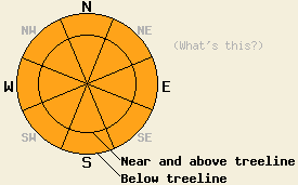
New wind slabs and storm slabs started to form as a result of the snow and wind impacting the forecast area. These slabs will continue to grow as the snow and wind continue today. Human triggered avalanches involving these slabs will be possible today. If rain falls on these wind slabs avalanches involving these wind slabs could become easier to trigger. The NW-N-NE-E aspects in near and above treeline terrain above 9000 ft. where more snow has fallen will represent the most likely places to find this instability.
CONSIDERABLE avalanche danger exists on snow-covered slopes steeper than 35 degrees due to a mix of rain on snow, new snow, and wind. Human triggered avalanches are likely today and natural avalanches will be possible.
| 0600 temperature: | 31-38 deg. F. |
| Max. temperature in the last 24 hours: | 31-42 deg. F. |
| Average wind direction during the last 24 hours: | Southwest |
| Average wind speed during the last 24 hours: | 55 mph |
| Maximum wind gust in the last 24 hours: | 60 mph |
| New snowfall in the last 24 hours: | .5-2 inches of liquid. Below 8500 ft most of this fell as rain - above 8500 ft it translated into snow of about 3-9 inches |
| Total snow depth: | 38-54 inches |
For 7000-8000 ft: |
|||
| Wednesday: | Wednesday Night: | Thursday: | |
| Weather: | Rain and snow with snow levels rising above 8500 ft. | Snow showers tapering off through the night. Snow levels falling below 7000 ft after 10 pm. | Partly cloudy |
| Temperatures: | 34-41 deg. F. | 23-30 deg. F. | 38-45 deg. F. |
| Wind direction: | Southwest | West | West |
| Wind speed: | 20-25 mph with gusts to 40 mph | 15-25 mph with gusts to 35 mph | 10-15 mph with gusts to 25 mph |
| Expected snowfall: | 4-8 in. | Trace in. | O in. |
For 8000-9000 ft: |
|||
| Wednesday: | Wednesday Night: | Thursday: | |
| Weather: | Snow in the morning becoming a snow rain mix in the afternoon as snow levels rise to around 8500 ft. | Snow showers tapering off through the night. Snow levels falling below 7000 ft after 10 pm. | Partly cloudy |
| Temperatures: | 34-40 deg. F. | 21-28 deg. F. | 35-42 deg. F. |
| Wind direction: | Southwest | West | West |
| Wind speed: | 30-40 mph with gusts to 65 mph decreasing to 25-35 mph with gusts to 50 mph in the afternoon | 20-30 mph with gusts to 45 mph decreasing to 15-20 mph with gusts to 35 mph after midnight | 15-25 mph with gusts to 40 mph |
| Expected snowfall: | 4-10 in. | trace in. | O in. |


This website is owned and maintained by the non-profit arm of the Sierra Avalanche Center. Some of the content is updated by the USDA avalanche forecasters including the forecasts and some observational data. The USDA is not responsible for any advertising, fund-raising events/information, or sponsorship information, or other content not related to the forecasts and the data pertaining to the forecasts.

