In partnership with: 
|
December 7, 2012 at 7:53 am |
|
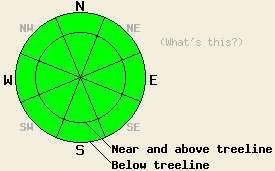
Avalanche danger is LOW for all elevations and aspects. Normal caution is advised. Long, unarrested sliding falls down icy slopes leading to impact with trees or rocks is likely the greatest hazard in the backcountry today. |
|
|
|
Fairly benign weather is expected through this weekend. A weather system passing to the north and east of the forecast area will increase ridgetop winds to moderate in speed. Beyond that, above average air temperatures are expected today with air temperatures slightly colder and closer to average through the weekend. Remote sensors are reporting air temperatures above 8,000' in the upper 20s to low 30s this morning. Air temperatures are forecast to warm into the mid 30s to mid 40s today for most areas above 7,000'. Winds shifted from southwest to northeast yesterday evening and are light in speed this morning. Winds are expected to shift back to the west and increase to moderate in speed by this afternoon.
Observations made yesterday on Mt. Tallac (Desolation Wilderness area), Rubicon Peak (West Shore Tahoe area), and Tamarack Peak (Mount Rose area) all revealed firm and frozen surface conditions up to 9,200'. Supportable rain crust existed on all aspects below 9,200' with areas of breakable crust between 9,200' and 9,500'. A short period of snow surface softening occurred on direct south aspects below 9,000', but all other areas remained very frozen with penetration into the snow surface difficult in most areas below 9,000'. Deeper in the snowpack, rain wetted layers that are in a slow process of refreezing have shown no evidence of snowpack instability or near crust facet formation over the past two days (photos, pit profiles, more info).
Avalanche Concerns:
Avalanche concerns for today are few. A frozen/refreezing icy snowpack displaying a widespread lack of instability combined with minimal solar radiation at this time of year will keep avalanche activity unlikely today. A short window of snow surface melting is expected today on direct south aspects, but not enough to cause any concerns for wet loose or wet slab avalanches. Little to no snow is available for wind transport, so new wind slab formation is unlikely today despite increasing west winds. Long, unarrested sliding falls down icy slopes leading to impact with trees or rocks is likely the greatest hazard in the backcountry today.
Avalanche danger is LOW for all elevations and aspects. Normal caution is advised. Long, unarrested sliding falls down icy slopes leading to impact with trees or rocks is likely the greatest hazard in the backcountry today.
| 0600 temperature: | 28 to 32 deg. F. |
| Max. temperature in the last 24 hours: | 35 to 41 deg. F. |
| Average wind direction during the last 24 hours: | Southwest shifting to northeast |
| Average wind speed during the last 24 hours: | 19 mph |
| Maximum wind gust in the last 24 hours: | 30 mph |
| New snowfall in the last 24 hours: | O inches |
| Total snow depth: | 35 to 48 inches |
For 7000-8000 ft: |
|||
| Friday: | Friday Night: | Saturday: | |
| Weather: | Partly cloudy skies. | Partly cloudy skies. | Partly cloudy skies. |
| Temperatures: | 39 to 46 deg. F. | 30 to 36 deg. F. | 39 to 44 deg. F. |
| Wind direction: | N shifting to W | W | SW shifting to N |
| Wind speed: | 15 to 20 mph with gusts to 30 mph in the afternoon. | 15 to 20 mph with gusts to 30 mph. | 10 to 15 mph with gusts to 25 mph. |
| Expected snowfall: | O in. | O in. | O in. |
For 8000-9000 ft: |
|||
| Friday: | Friday Night: | Saturday: | |
| Weather: | Partly cloudy skies. | Partly cloudy skies. | Partly cloudy skies. |
| Temperatures: | 34 to 44 deg. F. | 25 to 32 deg. F. | 32 to 39 deg. F. |
| Wind direction: | N shifting to W | W | NW |
| Wind speed: | 20 to 30 mph with gusts to 50 mph in the afternoon. | 20 to 30 mph with gusts to 50 mph. | 20 to 30 mph with gusts to 40 mph. |
| Expected snowfall: | O in. | O in. | O in. |


This website is owned and maintained by the non-profit arm of the Sierra Avalanche Center. Some of the content is updated by the USDA avalanche forecasters including the forecasts and some observational data. The USDA is not responsible for any advertising, fund-raising events/information, or sponsorship information, or other content not related to the forecasts and the data pertaining to the forecasts.

