In partnership with: 
|
December 13, 2012 at 7:51 am |
|
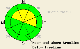
Near and above treeline, avalanche danger remains MODERATE on NW-N-NE-E aspects steeper than 35 degrees due to lingering wind slabs. For all other areas, avalanche danger is LOW. |
|
|
|
Occasional snow showers, below average air temperatures, and light winds are the expected weather for the next couple of days. New snow amounts from the past 24 hours are running 3 to 8 inches, bringing storm totals over the past 36 hours up to 6 to 12 inches. Ridgetop winds decreased to light in speed overnight and have shifted from southwest to the northeast. Remote sensors are reporting air temperatures in the low to mid teens across the forecast area this morning, with single digits in a few locations. Maximum daytime air temperature are expected to warm into the 20s today for most locations.
Observations made yesterday on Elephant's Back (Carson Pass area) and on Tamarack Peak (Mount Rose area) revealed human triggered wind slab avalanches failing within the storm snow. In both areas, the avalanches occurred on heavily wind loaded N-NE-E aspects in near treeline and above treeline areas. The snowpack was noted to have failed on a lower density layer of new snow just below the wind slab (photos, video, more info).
On Elephant's Back, collapse of the December 2nd facet layer, located just below the rain crust at the old/new snow interface was triggered by two individuals standing together on the very edge of a heavily wind loaded slope. The collapse dropped the snowpack 1 to 2 inches and triggered a wind slab avalanche within the storm snow. On Tamarack Peak, snowpit tests in a variety of locations indicated continued stability of this layer in the area, with insufficient load to cause collapse of the facet layer (photos, video, more info).
Avalanche Problem #1: Wind Slabs
Lingering unstable wind slabs are expected today, mainly near and above treeline on recently wind loaded NW-N-NE-E aspects. The density change that aided in the formation of these slabs yesterday has the potential to remain an active weak layer today. Slab depth associated with these avalanches is likely to be less than 1 foot deep, but will have the potential to bury or injure a person, especially if terrain traps or impact with trees are involved.
Avalanche Problem #2: Persistent Slabs
Rain on snow on December 2nd placed a few inches of new snow between two rain crusts. This snow has subsequently faceted since that time and become a weak layer. This layer is widespread and is most well developed on NW-N-NE aspects between 7,500' and 10,000'. At this time, only isolated areas seem to have sufficient new snow loading on top of this layer to bring it close to the state of collapse. Heavily wind loaded NE aspects are the most suspect at this time. As additional new snow loading occurs over the next week or two, this layer warrants continued monitoring. Failure of this layer will occur deeper within the snowpack than storm snow instability. The Dec 2nd facet layer is easily identified, as it is located just below the first crust encountered when digging down into the snowpack.
Near and above treeline, avalanche danger remains MODERATE on NW-N-NE-E aspects steeper than 35 degrees due to lingering wind slabs. For all other areas, avalanche danger is LOW.
| 0600 temperature: | 12 to 15 deg. F. |
| Max. temperature in the last 24 hours: | 22 to 25 deg. F. |
| Average wind direction during the last 24 hours: | Southwest shifting to northeast |
| Average wind speed during the last 24 hours: | 18 mph |
| Maximum wind gust in the last 24 hours: | 46 mph |
| New snowfall in the last 24 hours: | 3 to 8 inches |
| Total snow depth: | 46 to 51 inches |
For 7000-8000 ft: |
|||
| Thursday: | Thursday Night: | Friday: | |
| Weather: | Partly cloudy skies with a slight chance of snow. | Partly cloudy skies. | Mostly cloudy skies with a slight chance of snow showers. |
| Temperatures: | 21 to 28 deg. F. | 16 to 22 deg. F. | 21 to 28 deg. F. |
| Wind direction: | NE | Variable | Variable |
| Wind speed: | Light winds becoming 10 to 15 mph in the afternoon. | Light winds. | Light winds. |
| Expected snowfall: | 0 to trace in. | O in. | 0 to trace in. |
For 8000-9000 ft: |
|||
| Thursday: | Thursday Night: | Friday: | |
| Weather: | Partly cloudy skies with a slight chance of snow. | Partly cloudy skies. | Mostly cloudy skies with a slight chance of snow showers. |
| Temperatures: | 19 to 24 deg. F. | 10 to 17 deg. F. | 16 to 22 deg. F. |
| Wind direction: | E | E | Variable |
| Wind speed: | Light winds becoming 10 to 15 mph in the afternoon. | 10 to 15 mph in the evening, becoming light. | Light winds. |
| Expected snowfall: | 0 to trace in. | O in. | 0 to trace in. |


This website is owned and maintained by the non-profit arm of the Sierra Avalanche Center. Some of the content is updated by the USDA avalanche forecasters including the forecasts and some observational data. The USDA is not responsible for any advertising, fund-raising events/information, or sponsorship information, or other content not related to the forecasts and the data pertaining to the forecasts.

