In partnership with: 
|
December 14, 2012 at 7:45 am |
|
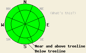
Avalanche danger is LOW for all elevations and aspects. Normal caution is advised. Isolated areas of instability may exist, especially in extreme terrain. |
|
|
|
Moisture out ahead of the next weather system expected to come onshore tomorrow afternoon will push some cloud cover into the forecast area today. Expect a slight chance of snow showers, below average air temperatures, and light winds. Remote sensors above 6,800' are reporting air temperatures mainly in the teens this morning with a few isolated areas in the single digits. An air temperature inversion has cold air on the mountain valley floors this morning with low single digits and near zero readings. Air temperatures are forecast to warm into the mid teens to mid 20s today for areas above 7,000'.
Observations made yesterday on Castle Peak (Donner Summit area) revealed small lingering areas of minor wind slab instability. Very minor cracking occurred in previously wind loaded areas. All of the fractured slabs were too small to present a hazard to backcountry travelers. Widespread surface hoar was observed above 8,000' in all but the most sun and wind exposed areas (photos, pit profile, more info). Keep an eye out for areas of surface hoar that are not destroyed prior to the next snowfall. With the forecast below average air temperatures and light winds, there is a chance that this layer could become buried before it is destroyed.
Observations made yesterday on Powderhouse Peak (Luther Pass area) revealed a general lack of slab formation below treeline. No evidence of slab instability was observed in this area (pit profile, video, more info). On both Castle Peak and Powderhouse Peak, snowpit tests targeting the Dec 2nd facet layer indicated that the snowpack load and slab properties above this layer had not yet reached a critical stage.
Avalanche Problem #1: Wind Slabs
Triggering a wind slab avalanche is unlikely today, but one might find an isolated area of instability in extreme terrain. Slab depth is likely to be less than 1 foot deep, but could have the potential to bury or injure a person if a terrain trap or impact with trees is involved.
Avalanche Problem #2: Persistent Slabs
Rain and snow on December 2nd placed a few inches of new snow between two rain crusts. This snow has subsequently faceted since that time and become a weak layer. This layer is widespread and is most well developed on NW-N-NE aspects between 7,500' and 10,000'. At this time, only very isolated areas seem to have sufficient snow load and slab characteristics on top of this layer to bring it close to failure. Heavily wind loaded NE aspects are the most suspect. Triggering an avalanche on this layer is unlikely today, but as additional new snow loading occurs over the next week or two, this layer warrants continued monitoring. Failure of this layer will occur deeper within the snowpack than storm snow instability. The Dec 2nd facet layer is easily identified, as it is the sugary snow located just below the first crust encountered when digging down into the snowpack.
Avalanche danger is LOW for all elevations and aspects. Normal caution is advised. Isolated areas of instability may exist, especially in extreme terrain.
| 0600 temperature: | 13 to 18 deg. F. |
| Max. temperature in the last 24 hours: | 21 to 25 deg. F. |
| Average wind direction during the last 24 hours: | East shifting to southwest |
| Average wind speed during the last 24 hours: | 10 mph |
| Maximum wind gust in the last 24 hours: | 17 mph |
| New snowfall in the last 24 hours: | O inches |
| Total snow depth: | 43 to 51 inches |
For 7000-8000 ft: |
|||
| Friday: | Friday Night: | Saturday: | |
| Weather: | Mostly cloudy skies with a slight chance of snow showers in the afternoon. | Mostly cloudy skies with a slight chance of snow showers. | Mostly cloudy skies with a slight chance of snow showers in the afternoon. |
| Temperatures: | 19 to 26 deg. F. | 13 to 19 deg. F. | 24 to 31 deg. F. |
| Wind direction: | Variable | Variable | SW |
| Wind speed: | Light winds | Light winds | Light winds increasing to 10 to 15 mph with gusts to 25 mph in the afternoon. |
| Expected snowfall: | 0 to trace in. | 0 to trace in. | 0 to trace in. |
For 8000-9000 ft: |
|||
| Friday: | Friday Night: | Saturday: | |
| Weather: | Mostly cloudy skies with a slight chance of snow showers in the afternoon. | Mostly cloudy skies with a slight chance of snow showers. | Mostly cloudy skies with a slight chance of snow showers in the afternoon. |
| Temperatures: | 13 to 20 deg. F. | 9 to 16 deg. F. | 18 to 26 deg. F. |
| Wind direction: | Variable | NE | N shifting to W |
| Wind speed: | Light winds | Light winds increasing to 10 to 15 mph after midnight. | 10 to 15 mph with gusts to 25 mph. |
| Expected snowfall: | 0 to trace in. | 0 to trace in. | 0 to trace in. |


This website is owned and maintained by the non-profit arm of the Sierra Avalanche Center. Some of the content is updated by the USDA avalanche forecasters including the forecasts and some observational data. The USDA is not responsible for any advertising, fund-raising events/information, or sponsorship information, or other content not related to the forecasts and the data pertaining to the forecasts.

