In partnership with: 
|
December 15, 2012 at 8:01 am |
|
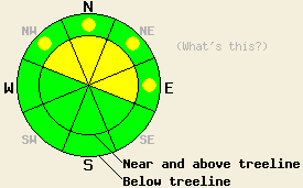
Near and above treeline, avalanche danger is MODERATE due to wind slabs on NW-N-NE-E aspects on slopes 35 degrees and steeper. Below treeline, avalanche danger is LOW with pockets of MODERATE danger on wind loaded NW-N-NE-E aspects on slopes 35 degrees and steeper. |
|
|
|
A weak weather system will move through the forecast area today and tomorrow. Light snowfall is expected by this afternoon with up to 3 of inches of accumulation expected over the next 24 hours. The biggest concern is increasing southwest winds which will be plenty strong enough to move snow. Snow showers over the past 24 hours have brought a trace to 1 inch of new snow accumulation across the forecast area. Remote sensors are reporting air temperatures this morning in the mid single digits to mid teens across the area and across the elevation spectrum. Air temperatures are expected to warm into the upper teens to mid 20s today for areas above 7,000'.
Ridgetop winds were stronger than forecast yesterday. With plenty of snow on the ground available for wind transport, small wind slabs formed above treeline on wind loaded NW-N-NE-E aspects. Small but widespread human triggered, shallow soft wind slab avalanches were observed yesterday on Red Lake Peak (Carson Pass area). No observed avalanches were large enough to harm a person. Crown depth ranged from 6 to 16 inches deep, with propagation up to up to 100 ft wide. Debris ran up to 800 ft. Slab thickness was significantly shallower just down slope of start zones, minimizing harmful potential. The weak layer was a storm snow density change 2 to 4 inches above the uppermost rain crust. Complex terrain with several wind loaded mid-slope features resulted in human triggered avalanching throughout Crater Lake drainage (photos, videos, more info). A similar human triggered wind slab avalanche was reported above treeline in a gully on the NE side of Mt. Houghton (Mount Rose area) (more info).
Just below Grouse Rocks (Ward Canyon area) snowpit data targeting the Dec 2nd facet layer revealed unstable results with fracture propagation likely following weak layer collapse. The tests were performed in near to below treeline terrain on a N aspect at 8,140'. No new avalanches were observed in the area, but the snowpit tests indicated that a human triggered persistent slab avalanche was possible if the right slope and the right trigger point were loaded (video, pit profile, more info). On Red Lake Peak (Carson Pass area) snowpit tests also targeting the Dec 2nd facet layer indicated that fracture propagation was likely following weak layer collapse (video, more info). Observations targeting this layer on Tamarack Peak (Mount Rose area) indicated that propagation was unlikely, but that the layer was weak enough to show sudden collapse properties (pit profile, videos.more info). No other signs of instability or avalanche activity were observed in this area.
Avalanche Problem #1: Wind Slabs
Increasing SW winds will transport more snow into lee areas today, mainly on NW-N-NE-E aspects. The size and depth of wind slabs that formed yesterday will become larger today. Triggering a wind slab avalanche that is large enough to bury or injure a person is possible today. Slab depth up to 2 feet deep may occur.
Avalanche Problem #2: Persistent Slabs
Rain and snow on December 2nd placed a few inches of new snow between two rain crusts. This snow has subsequently faceted since that time and become a weak layer. This layer is widespread and is most well developed on NW-N-NE aspects between 7,500' and 10,000'. At this time, only very isolated areas seem to have sufficient snow load and slab characteristics on top of this layer to bring it close to failure. Wind loaded N-NE aspects are the most suspect. Triggering an avalanche on this layer is unlikely in most areas today, but areas of significant fresh wind loading on top of this weak layer may be sufficient to tip the balance of stability. As additional new snow loading occurs over the next week or two, this layer warrants continued monitoring. Failure of this layer will occur deeper within the snowpack than storm snow instability. The Dec 2nd facet layer is easily identified, as it is the sugary snow located just below the first crust encountered when digging down into the snowpack.
Near and above treeline, avalanche danger is MODERATE due to wind slabs on NW-N-NE-E aspects on slopes 35 degrees and steeper. Below treeline, avalanche danger is LOW with pockets of MODERATE danger on wind loaded NW-N-NE-E aspects on slopes 35 degrees and steeper.
| 0600 temperature: | 7 to 14 deg. F. |
| Max. temperature in the last 24 hours: | 17 to 21 deg. F. |
| Average wind direction during the last 24 hours: | Southwest |
| Average wind speed during the last 24 hours: | 18 mph |
| Maximum wind gust in the last 24 hours: | 31 mph |
| New snowfall in the last 24 hours: | trace to 1 inches |
| Total snow depth: | 43 to 51 inches |
For 7000-8000 ft: |
|||
| Saturday: | Saturday Night: | Sunday: | |
| Weather: | Mostly cloudy skies with a chance of snow in the afternoon. | Cloudy skies with a chance of snow. | Cloudy skies with snow likely. |
| Temperatures: | 21 to 27 deg. F. | 18 to 24 deg. F. | 25 to 32 deg. F. |
| Wind direction: | SW | SW | SW |
| Wind speed: | Light winds increasing to 15 to 20 mph with gusts to 30 mph in the afternoon. | 15 to 20 mph with gusts to 30 mph. | 20 to 30 mph with gusts to 45 mph. |
| Expected snowfall: | Up to 1 in. | Up to 1 in. | Up to 3 in. |
For 8000-9000 ft: |
|||
| Saturday: | Saturday Night: | Sunday: | |
| Weather: | Mostly cloudy skies with a chance of snow in the afternoon. | Cloudy skies with a chance of snow. | Cloudy skies with snow likely. |
| Temperatures: | 18 to 25 deg. F. | 15 to 22 deg. F. | 23 to 28 deg. F. |
| Wind direction: | SW | SW | SW |
| Wind speed: | Light winds increasing to 20 to 25 mph with gusts to 35 mph in the afternoon. | 20 to 30 mph with gusts to 45 mph. | 35 to 45 mph with gusts 55 to 70 mph. |
| Expected snowfall: | Up to 1 in. | Up to 2 in. | Up to 3 in. |


This website is owned and maintained by the non-profit arm of the Sierra Avalanche Center. Some of the content is updated by the USDA avalanche forecasters including the forecasts and some observational data. The USDA is not responsible for any advertising, fund-raising events/information, or sponsorship information, or other content not related to the forecasts and the data pertaining to the forecasts.

