In partnership with: 
|
December 18, 2012 at 7:53 am |
|
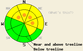
Near and above treeline pockets of CONSIDERABLE avalanche danger remain on the NW-N-NE-E aspects on slopes steeper than 35 degrees due to fragile wind slabs resting on buried weak layers. Below treeline, the avalanche danger is MODERATE on wind loaded NW-N-NE-E aspects steeper than 35 degrees. Human triggered avalanches will be possible in many areas today and likely in some of the most heavily wind loaded areas. |
|
|
|
The storm that has impacted the region over the last 24 hours deposited another 4-8 inches of new snow above 7000 ft since yesterday morning. The gale force winds accompanying this storm have subsided and started to shift to the north and east. Some snow showers should continue today with light accumulations of 2-4 inches in the mountains. By tonight the snow should end. Temperatures should continue to fall today as a mass of cold air following the storm arrives across the forecast area. The forecast calls for overnight lows in the single digits and daytime highs tomorrow in the teens and low 20's. Partly clear skies and light northerly winds should provide a break in the weather tomorrow. By the afternoon the winds should begin increasing and shifting back to the southwest as another storm approaches.
Several wide and long running avalanches occurred yesterday. Observers reported two significant natural avalanches in the Mt. Rose backcountry: one on Incline Lake Peak (details) in the morning that stepped down to the Dec 2nd facets and one on Fireplug (more info) in the afternoon. Another natural release occurred on Wildflower Ridge (photos) on the flanks of Mt. Judah. In addition to these natural releases, human triggered avalanches occurred on Castle Peak and Incline Lake Peak. The slide on Castle Peak occurred on a wind loaded NW aspect. It started in the new snow and stepped down to the rain crust above the Dec 2nd facets. Observers reported wind loading continued throughout the day and was enough to refill some of the slides that happened earlier in the day (photo, video). Snowpit tests on Incline Lake Peak (snowpit, video) and on Mt. Judah (videos) showed two distinct weaknesses: 1) the interface between the dense snow from Dec 17th and the lighter snow below it, and 2) the Dec 2 facet layer underneath the first buried rain crust. Tests showed that each of these layers could easily break and that the resulting fracture would quickly propagate along the weakness.
Avalanche Problem #1: Wind Slabs
Extensive wind slabs several feet deep still lurk on the wind loaded slopes. These dense wind slabs rest on lighter weaker snow that could barely hold them in place yesterday. Triggering a large wind slab avalanches will remain possible today in any wind loaded areas and could be likely on the most heavily wind loaded slopes. The largest and most sensitive wind slabs will exist on near and above treeline NW-N-NE-E aspects. Some wind slabs may also reside on wind loaded slopes in below treeline terrain due to the strength of the winds. Any avalanches that start as wind slabs could add enough weight to the snowpack to step down to deeper layers like the rain crust above the Dec 2nd facets or the facets themselves.
Avalanche Problem #2: Persistent Slabs
In some areas the new snow and wind have added enough new load on top of the snowpack to push the Dec 2nd facet layer to the edge of failure with the only missing avalanche ingredient being a trigger. In these areas human triggered avalanches on this layer will be possible. In other areas the rain crust above the facet layer remains strong enough to prevent force from reaching that weak layer of sugary snow. The uncertainty associated with where this layer could react and where it may still be dormant makes conservative decisions and careful snowpack evaluation a prudent course of action for today. The most well developed and weakest facets exist on the NW-N-NE aspects between 7,500 ft. and 10,000 ft. The rain crust above the facets seems weakest at the higher elevations. Larger triggers like multiple people on a slope or other avalanches could cause this layer to fail even in areas where the rain crust remains strong.
Near and above treeline pockets of CONSIDERABLE avalanche danger remain on the NW-N-NE-E aspects on slopes steeper than 35 degrees due to fragile wind slabs resting on buried weak layers. Below treeline, the avalanche danger is MODERATE on wind loaded NW-N-NE-E aspects steeper than 35 degrees. Human triggered avalanches will be possible in many areas today and likely in some of the most heavily wind loaded areas.
| 0600 temperature: | 12-17 deg. F. |
| Max. temperature in the last 24 hours: | 25-30 deg. F. |
| Average wind direction during the last 24 hours: | Southwest shifting to the Northeast |
| Average wind speed during the last 24 hours: | 40 mph decreasing overnight to 10-20 mph |
| Maximum wind gust in the last 24 hours: | Yesterday morning @ 7 am: 91 mph | Since 7pm last night: 39 mph |
| New snowfall in the last 24 hours: | 4-8 inches |
| Total snow depth: | 46-55 inches |
For 7000-8000 ft: |
|||
| Tuesday: | Tuesday Night: | Wednesday: | |
| Weather: | Cloudy with snow showers. | Mostly cloudy with scattered snow showers in the evening. | Partly to mostly cloudy |
| Temperatures: | 20-25 decreasing in the afternoon to 12-17 deg. F. | 12-17 deg. F. | 21-26 deg. F. |
| Wind direction: | Variable | Variable | East shifting to the southwest in the afternoon |
| Wind speed: | Light | Light | 10-15 mph with gusts to 30 mph |
| Expected snowfall: | 2-4 in. | trace in. | O in. |
For 8000-9000 ft: |
|||
| Tuesday: | Tuesday Night: | Wednesday: | |
| Weather: | Cloudy with snow showers. | Mostly cloudy with scattered snow showers in the evening. | Partly to mostly cloudy |
| Temperatures: | 18-23 decreasing in the afternoon to 7-12 deg. F. | 5-12 deg. F. | 16-23 deg. F. |
| Wind direction: | Northwest to Northeast | Northeast | Northeast shifting to the southwest in the afternoon |
| Wind speed: | 10-20 mph with gusts to 30 mph in the morning | 10-20 mph with gusts to 30 mph | 15-25 mph with gusts to 45 mph in the afternoon |
| Expected snowfall: | 2-4 in. | trace in. | O in. |


This website is owned and maintained by the non-profit arm of the Sierra Avalanche Center. Some of the content is updated by the USDA avalanche forecasters including the forecasts and some observational data. The USDA is not responsible for any advertising, fund-raising events/information, or sponsorship information, or other content not related to the forecasts and the data pertaining to the forecasts.

