In partnership with: 
|
December 21, 2012 at 7:24 am |
|
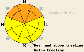
Both above and below treeline, avalanche danger will rise to CONSIDERABLE today on NW-N-NE aspects on slopes 35 degrees and steeper due to wind slabs and persistent slabs. For other areas, avalanche danger is MODERATE on slopes 35 degrees and steeper. Avalanche danger is expected to further increase to HIGH danger tonight as continued snowfall occurs. |
|
|
|
The timing has slowed a bit for the first wave of moisture set to impact the forecast area today. Snowfall is now expected to begin during the late morning hours and become more widespread during the afternoon. New snowfall amounts of 5 to 10 inches are forecast today for areas above 7,000'. The greatest snowfall amounts are expected to occur along the Sierra Crest north of Hwy 50. A multi day storm event is expected to bring 3 to 5 feet of new snow to the forecast area through Sunday. Strong to gale force southwest winds continue this morning with ridgetop gusts to 100 mph expected to continue through tomorrow. Air temperatures above 8,000' are in the 20s this morning, having warmed up in southwest flow ahead of the approaching storm system. Air temperatures are forecast to remain in the 20s today before starting a cooling trend tonight and tomorrow.
Recent Observations: The existing snowpack is in poor condition to handle new snow loading.
Observations made yesterday in the Carson Pass, Mount Rose, and Donner Summit areas all showed unstable new wind slab development and ongoing concern for buried facet layers. Significant amounts of blowing snow were observed in most near and above treeline areas yesterday as strong to gale force SW winds moved snow that had fallen Monday night and Tuesday under light wind conditions. This created a new round of wind slab development on NW-N-NE aspects with widespread skier triggered shooting cracks to 30 feet in length observed in the Carson Pass area by multiple parties. Other areas showed unstable snowpit test results on newly formed wind slabs (more info, video, photos).
Snowpit tests targeting the Dec 2 and Dec 12 facet layers once again gave variable results, as they have for the past few days. Overall the message remains much the same, that there is ongoing instability concerns several feet deep in the existing snowpack in a variety of areas. The Dec 2 facet layer (located below the uppermost prominent rain crust in the snowpack) is widespread and exists in nearly all areas on NW-N-NE aspects between 7,500' and 10,000'. Snowpit tests targeting this layer have shown a high degree of variability with this layer stable in some areas and continued unstable in other areas. The Dec 12 facet layer (located on top of the rain crust that caps the Dec 2 facet layer) is more spotty in distribution, having been observed on NW-N-NE aspects on Powerhouse Peak (Luther Pass area), in the Davis and Winters Creek drainages (Mount Rose area), and on northerly aspects around Castle Peak (Donner Summit area). In recent days, the Dec 12 layer has shown more consistent unstable snowpit test results than the Dec 2 layer (more info, photos, video).
Avalanche Problem #1: Wind Slabs
A mix of new and old wind slabs are widespread across the forecast area . These slabs have shown significant signs of instability and are are likely to fail with human triggers or additional new snow loading today. These wind slabs are most prominent in directly wind loaded areas on NW-N-NE aspects mainly near and above treeline. Some smaller wind slabs have been observed below treeline due to the strength of the winds. Thickness for the wind slabs that formed yesterday is 6 to 12 inches and will grow thicker today. This is on top of already existing wind slabs with lingering instability that are also around 1 foot thick.
Avalanche Problem #2: Persistent Slabs
Faceted snow crystals that exist below the rain crust that formed out of the Dec 2nd rain and snow event present a weak layer that is widespread around the forecast area on NW-N-NE aspects between 7,500' and 10,000'. This combined with more isolated areas where the Dec 12 facet layer exists, presents multiple persistent weak layers of concern. These weak layers are around 2 feet deep in most areas. The most heavily wind loaded areas hold pockets where these weak layers are up to 6 feet deep. These weak layers are likely to fail at some point during this storm cycle. There is uncertainty as the where and when these facet layers will fail and if it will occur early or late in the storm cycle. Avalanches that initiate higher in the snowpack could trigger collapse of, or step down to the deeper facet layers. Any avalanches that fail on these facet layers will be large and destructive.
Both above and below treeline, avalanche danger will rise to CONSIDERABLE today on NW-N-NE aspects on slopes 35 degrees and steeper due to wind slabs and persistent slabs. For other areas, avalanche danger is MODERATE on slopes 35 degrees and steeper. Avalanche danger is expected to further increase to HIGH danger tonight as continued snowfall occurs.
| 0600 temperature: | 21 to 26 deg. F. |
| Max. temperature in the last 24 hours: | 22 to 31 deg. F. |
| Average wind direction during the last 24 hours: | Southwest |
| Average wind speed during the last 24 hours: | 47 mph |
| Maximum wind gust in the last 24 hours: | 76 mph |
| New snowfall in the last 24 hours: | O inches |
| Total snow depth: | 45 to 56 inches |
For 7000-8000 ft: |
|||
| Friday: | Friday Night: | Saturday: | |
| Weather: | Cloudy skies with a chance of snow late in the morning. Snow becoming widespread in the afternoon. | Cloudy skies with snow. | Cloudy skies with snow. |
| Temperatures: | 31 to 36 deg. F. | 24 to 28 deg. F. | Steady in the mid 20s deg. F. |
| Wind direction: | S | S | SW |
| Wind speed: | 30 to 45 mph with gust to 65 mph. | 30 to 45 mph with gust to 65 mph. | 30 to 40 mph with gusts to 65 mph. |
| Expected snowfall: | 5 to 10 in. | 5 to 10 in. | 8 to 16 in. |
For 8000-9000 ft: |
|||
| Friday: | Friday Night: | Saturday: | |
| Weather: | Cloudy skies with a chance of snow late in the morning. Snow becoming widespread in the afternoon. | Cloudy skies with snow. | Cloudy skies with snow. |
| Temperatures: | 26 to 31 deg. F. | 20 to 25 deg. F. | Steady in the lower 20s deg. F. |
| Wind direction: | SW | SW | SW |
| Wind speed: | 65 to 75 mph with gusts to 100 mph. | 60 to 70 mph with gust to 100 mph. | 55 to 65 mph with gusts to 100 mph. |
| Expected snowfall: | 5 to 10 in. | 5 to 10 in. | 8 to 16 in. |


This website is owned and maintained by the non-profit arm of the Sierra Avalanche Center. Some of the content is updated by the USDA avalanche forecasters including the forecasts and some observational data. The USDA is not responsible for any advertising, fund-raising events/information, or sponsorship information, or other content not related to the forecasts and the data pertaining to the forecasts.

