In partnership with: 
|
December 22, 2012 at 8:00 am |
|
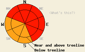
The avalanche danger is HIGH at all elevations on the NW-N-NE-E-SE aspects on slopes steeper than 33 degrees due to new snow loading an already weak snowpack. Large, destructive human triggered and natural avalanches will be widespread today. Very Dangerous avalanche conditions exist, and travel in or below avalanche terrain is not recommenced. |
|
|
|
A low pressure sitting offshore of British Columbia will continue to direct waves of winter storms into the forecast area. Yesterday's initial wave came in slower and weaker than forecasted. It only brought 4-12 inches of accumulation with it. On both sides of Lake Tahoe, areas north of Emerald Bay received 6-12 inches, while those areas to the south picked up 4-10 inches. The second storm wave should arrive this morning with stronger southwest winds, more snowfall, and colder temperatures. The snow levels should fall below 5000 ft. today and tonight. The forecast calls for southwest winds to remain in the 50-60 mph range with gusts near 100 mph through tomorrow morning. This second storm wave could also produce an additional 18-28 inches of snow by tomorrow morning. The third wave should arrive on Sunday bringing even more snow and wind. This last wave does have some warmer air associated with it and bring snow levels up to around 6000 ft. Click here for a weather briefing from the Reno NWS.
Recent Observations: The existing snowpack is in poor condition to handle new snow loading.
Observations on Becker Peak (videos and more info), Silver Peak (snowpit and video), and Mt Judah (snowpit and more info) yesterday all showed a snowpack already on the edge of failure. Shallow wind slabs resting on lighter weaker snow on top of a the early December crust/facet layers sums up the snowpack structure in all three areas. Other recent observations around the forecast area show similar snowpack characteristics. Tests on these weaknesses yesterday on Silver, Becker, and Judah indicated that they cannot support additional snow loads and that failures that would result in avalanches remained possible on any of these weaknesses. Overall the data indicates a weak snowpack that will not handle new loading without widespread failures.
Avalanche Problem #1: Wind Slabs and Storm Slabs
Strong winds and new snow will continue to add weight and depth to the wind slabs that already exist across the forecast area. These wind slabs rest on top of the weak layers mentioned above. As the storms continue, variations in snowfall intensity, temperature, winds, and other storm characteristics will form additional weaknesses within the new snow. Large, destructive, and widespread natural and human triggered avalanches involving large wind slabs will occur today as the afore mentioned weak layers fail. The largest and most fragile wind slabs will exist on wind loaded and cross loaded NW-N-NE-E-SE aspects in both above and below treeline terrain. In more protected areas, some softer storm slabs will also form on top of the already weak snowpack, and failure of these softer slabs will be likely as well.
Avalanche Problem #2: Persistent Slabs
The additional 2-4 ft of new snow expected through Sunday should add enough load to cause the persistent weak layers near the Dec 12th rain crust to fail. One of these facet layers (the Dec 2nd one) remains buried below the crust and the other (the Dec 12th one) rests on top of the crust. Tests on these layers have shown that they have already reached the point of failure in some areas. In other areas tests have indicated that they are still holding on. This variablity means uncertainty remains as to exactly where and when these facet layers will fail during this storm, but avalanches resulting from the failure of these layers will become more and more widespread over the weekend. The most well developed and weakest facets exist on the NW-N-NE aspects between 7,500 ft. and 10,000 ft. The avalanches that result form the failure of these layers will fracture across wider areas and could easily break above or far to the side of the person who triggers them. Other avalanches could also step down to these deeper weaknesses. Any avalanches that fail on these facet layers will be large and destructive.
The avalanche danger is HIGH at all elevations on the NW-N-NE-E-SE aspects on slopes steeper than 33 degrees due to new snow loading an already weak snowpack. Large, destructive human triggered and natural avalanches will be widespread today. Very Dangerous avalanche conditions exist, and travel in or below avalanche terrain is not recommenced.
| 0600 temperature: | 21-26 deg. F. |
| Max. temperature in the last 24 hours: | 25-31 deg. F. |
| Average wind direction during the last 24 hours: | Southwest |
| Average wind speed during the last 24 hours: | 35-45 mph |
| Maximum wind gust in the last 24 hours: | 110 mph |
| New snowfall in the last 24 hours: | South of Emerald Bay: 4-10 inches | North of Emerald Bay: 6-12 inches |
| Total snow depth: | 53-68 inches |
For 7000-8000 ft: |
|||
| Saturday: | Saturday Night: | Sunday: | |
| Weather: | Snow | Snow | Snow |
| Temperatures: | 23-28 deg. F. | 18-23 deg. F. | 24-29 deg. F. |
| Wind direction: | Southwest | Southwest | Southwest |
| Wind speed: | 20-35 mph with gusts to 55 mph | 15-30 mph with gusts to 50 mph | 15-30 mph with gusts to 45 mph |
| Expected snowfall: | 8-16 in. | 8-12 in. | 8-16 in. |
For 8000-9000 ft: |
|||
| Saturday: | Saturday Night: | Sunday: | |
| Weather: | Snow | Snow | Snow |
| Temperatures: | 20-25 deg. F. | 15-20 deg. F. | 22-27 deg. F. |
| Wind direction: | Southwest | Southwest | Southwest |
| Wind speed: | 50-65 mph with gusts to 100 mph | 45-60 mph with gusts to 95 mph decreasing to 35-50 mph with gusts to 75 mph after midnight | 35-50 mph with gusts to 80 mph |
| Expected snowfall: | 10-16 in. | 8-12 in. | 10-16 in. |


This website is owned and maintained by the non-profit arm of the Sierra Avalanche Center. Some of the content is updated by the USDA avalanche forecasters including the forecasts and some observational data. The USDA is not responsible for any advertising, fund-raising events/information, or sponsorship information, or other content not related to the forecasts and the data pertaining to the forecasts.

