In partnership with: 
|
December 30, 2012 at 7:48 am |
|
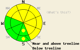
MODERATE avalanche danger exists today on slopes steeper than 35 degrees in both above and below treeline on NW-N-NE-E-SE aspects with pockets of MODERATE danger on the S aspects. Lingering wind slabs in isolated areas and heavy snow loads sitting on top of weak persistent deep slabs will allow large destructive human triggered avalanches to remain possible. Even though these avalanches have become less likely, the consequences of such a slide would be very high. |
|
|
|
The low pressure over NV pushed some snow showers into the mountains yesterday and last night. Along the Sierra Crest snow totals ranged from 1 to 3 inches. More snow fell in the mountains south and east of Lake Tahoe where up to 6 inches accumulated. This low should continue to push snow showers into the mountains today. The forecast calls for light snow accumulation with up to 2 inches by the end of the day. Similar to yesterday and last night, the areas on the east side of Lake Tahoe should see the most precipitation. As this system departs the region this afternoon and evening, the winds should shift to the NE as a high pressure ridge moves in. Cloud cover should decrease and temperatures should remain cold with overnight lows near zero in the mountain valleys and tomorrow's highs in the low 20's above 7000 ft.
Two reports of human triggered avalanches came in yesterday. The first occurred on Donner Peak in complex near treeline terrain in a steep NE facing chute. The crown on this slide measured about 12 to 18 inches and was about 100 ft wide (the whole width of the chute). This avalanche resulted from the failure of a lingering weakness within the recent snow. Debris from this slide buried the person who triggered it waist deep (for a first hand account click here). The second slide released above Angora Lakes on the NE side of Echo Peak. Initial reports indicate that three people were involved in the avalanche. Details about the size and weak layer remain unknown.
Snowpit data, ski cuts on test slopes, and other observations in less complex terrain on Powderhouse Peak (snowpit, more info) and in the Deep Creek Drainage (snowpit, photo, video) showed continued settlement and consolidation in the snowpack above the old persistent weak layers. On Powderhouse Peak between 8000 ft. and 9200 ft. 2 layers of weak sugary snow (known as the Dec. 12th and the Dec. 2nd facets) still exist around the uppermost rain crust. 2-3 m of snow sits above them in this area. In Deep Creek around 7900 ft. only 1.5 m of snow rests above those weak layers. Tests on the Dec. 2nd facets (the layer of facets below the crust) in the Deep Creek area showed that if they break, fractures can still easily travel through this weak layer.
Avalanche Problem #1: Persistent Deep Slabs
The 1.5-3 m (4-9 ft) of strong snow above the Dec. facet layers has made it less likely for a single person on a slope to break these deeply buried persistent weak layers. Unfortunately this same strong snow also makes a very thick slab layer, and it will hide most obvious signs of deep instabilities. In most places the snowpack will appear very stable until the right trigger finds the right spot on a slope. Larger triggers such as multiple people on a slope, other avalanches, or cornice collapses can cause failures in these deep weak layers. The resulting avalanches would fracture across wide areas and could easily propagate far above or far to the side of the trigger. The most well developed and weakest facets exist on NW-N-NE aspects between 7,500 ft. and 10,000 ft. However, they have been noted on some southerly and easterly aspects as well. Variability in the strength and distribution of the persistent weak layers means uncertainty remains as to exactly where and when persistent deep slab failure could occur. In summary, triggering an avalanche on these deeply buried layers has become less likely, but if one does occur it will be very large, deep, destructive, and dangerous.
Avalanche Problem #2: Wind Slabs
Tests, observations, and other data indicate that the upper sections of the snowpack continue to settle and consolidate. Triggering an avalanche due to a failure in the upper snowpack will be unlikely today in most areas. However, some fragile wind slabs like those triggered yesterday may still linger on isolated slopes in complex or extreme terrain or on unsupported slopes. This kind of terrain includes steep couloirs, cliffy areas, chutes, areas with multiple starting zones or avalanche paths and often contains numerous terrain traps and trigger points. Human triggered avalanches involving these slabs remain possible in these isolated areas. Avalanches resulting from the failure of these wind slabs could remain limited to the upper snowpack or in some cases could step down to the deeper weaknesses mentioned above. The largest and most fragile wind slabs will exist on isolated wind loaded and cross loaded NW-N-NE-E-SE aspects.
MODERATE avalanche danger exists today on slopes steeper than 35 degrees in both above and below treeline on NW-N-NE-E-SE aspects with pockets of MODERATE danger on the S aspects. Lingering wind slabs in isolated areas and heavy snow loads sitting on top of weak persistent deep slabs will allow large destructive human triggered avalanches to remain possible. Even though these avalanches have become less likely, the consequences of such a slide would be very high.
| 0600 temperature: | 14-18 deg. F. |
| Max. temperature in the last 24 hours: | 22-27 deg. F. |
| Average wind direction during the last 24 hours: | Variable mostly between NE and SW |
| Average wind speed during the last 24 hours: | 5-10 mph |
| Maximum wind gust in the last 24 hours: | 15 mph |
| New snowfall in the last 24 hours: | Southeast of Lake Tahoe up to 6 inches | Along the Sierra Crest: 1-3 inches |
| Total snow depth: | 65-94 inches |
For 7000-8000 ft: |
|||
| Sunday: | Sunday Night: | Monday: | |
| Weather: | Mostly cloudy with isolated snow showers in the afternoon | Partly cloudy becoming clear after midnight | Partly cloudy becoming mostly cloudy in the afternoon |
| Temperatures: | 14 to 21 deg. F. | 0 to 10 deg. F. | 19 to 26 deg. F. |
| Wind direction: | Northeast | East | East |
| Wind speed: | Light in the morning increasing to 10 mph in the afternoon | 10-15 mph with gusts to 25 mph | 10-15 mph with gusts to 25 mph in the morning decreasing in the afternoon |
| Expected snowfall: | up to 2 in. | O in. | O in. |
For 8000-9000 ft: |
|||
| Sunday: | Sunday Night: | Monday: | |
| Weather: | Mostly cloudy with isolated snow showers in the afternoon | Partly cloudy becoming clear after midnight | Partly cloudy becoming mostly cloudy in the afternoon |
| Temperatures: | 10 to 17 deg. F. | 6 to 12 deg. F. | 23 to 29 deg. F. |
| Wind direction: | North | Northeast | Northeast |
| Wind speed: | 15-20 mph with gusts to 30 mph | 15-20 mph with gusts to 35 mph | 20-25 mph with gusts to 35 mph decreasing to 10-15 mph with gusts to 25 mph in the afternoon |
| Expected snowfall: | up to 2 in. | O in. | O in. |


This website is owned and maintained by the non-profit arm of the Sierra Avalanche Center. Some of the content is updated by the USDA avalanche forecasters including the forecasts and some observational data. The USDA is not responsible for any advertising, fund-raising events/information, or sponsorship information, or other content not related to the forecasts and the data pertaining to the forecasts.

