In partnership with: 
|
January 9, 2013 at 8:00 am |
|
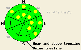
Above and below treeline, avalanche danger is LOW with pockets of MODERATE danger on NW-N-NE-E-SE aspects on slopes 35 degrees and steeper due to newly formed wind slabs. Human triggered avalanches will be possible today. Continued strong winds over the next 24 hours combined with new snow tonight will cause the avalanche danger to increase and become more widespread. |
|
|
|
The winds shifted back to the southwest and increased dramatically after midnight last night. Remote sensors indicated consistent wind speeds in the 40-60 mph range since early this morning. These winds should continue to increase ahead of a strong cold front. The forecast calls for cloud cover to increase today as well. By tonight this front should arrive bringing snow showers and temperatures in the single digits. Most of the snow should fall tonight. Above 7000 ft 1-5 inches of new snow could accumulate with the highest snowfall amounts in the northern part of the forecast area. Snow showers should taper off tomorrow as the storm departs the region. In its wake temperatures should remain cold and the winds should decrease. Click here for a graphic from the NWS showing this system.
Yesterday 4-8 inches of soft unconsolidated snow still existed on most of the NW-N-NE aspects at all elevations on Mt. Tallac and on Jakes Peak. This amount of soft snow also existed near the ridgeline on W-NW aspects on Tallac representing a great source of snow for strong SW winds to transport (photo, more info). Ski cuts, test pits, and handpits did not show any signs of instability on Tallac's northerly aspects. On the more sun exposed E-SE-S aspects a mix of wet snow and breakable melt freeze crusts existed yesterday on both Tallac and Jake's. Some skier triggered roller balls did occur on steep sun exposed SE aspects on Jake's Peak. These small wet snow instabilities remained very small and only involved the top 3-4 inches of wet snow (photos, more info).
Avalanche Problem #1: Wind Slabs
The winds have now shifted back to the SW and increased. This change in the winds combined with plenty of soft snow available for transport on the now windward slopes will allow wind slabs to form on the leeward NW-N-NE-E-SE aspects today. While most of these wind slabs should only reach a few inches in depth and not extend very far away from the ridgelines, some larger wind slabs up to a couple feet in depth could form in the most heavily wind loaded areas. Human triggering of these newly formed wind slabs will be possible today. Due to the strength of the winds, some wind slabs could also form in isolated areas below treeline or in more traditionally sheltered areas. Continued strong winds over the next 24 hours combined with new snow tonight will cause the winds slabs to become more widespread and will cause the avalanche danger to increase.
Above and below treeline, avalanche danger is LOW with pockets of MODERATE danger on NW-N-NE-E-SE aspects on slopes 35 degrees and steeper due to newly formed wind slabs. Human triggered avalanches will be possible today. Continued strong winds over the next 24 hours combined with new snow tonight will cause the avalanche danger to increase and become more widespread.
| 0600 temperature: | 30-34 deg. F. |
| Max. temperature in the last 24 hours: | 44-46 deg. F. |
| Average wind direction during the last 24 hours: | Southwest |
| Average wind speed during the last 24 hours: | Before midnight: 0-10 mph | After midnight: 40-60 mph |
| Maximum wind gust in the last 24 hours: | 76 mph |
| New snowfall in the last 24 hours: | O inches |
| Total snow depth: | 61-85 inches |
For 7000-8000 ft: |
|||
| Wednesday: | Wednesday Night: | Thursday: | |
| Weather: | Mostly cloudy | Cloudy with snow showers in the evening with snow becoming more widespread after midnight | Mostly cloudy with a chance of snow showers |
| Temperatures: | 35-42 deg. F. | 7-14 deg. F. | 8-15 deg. F. |
| Wind direction: | Southwest | Southwest | West |
| Wind speed: | 25-30 mph with gusts to 50 mph increasing to 40-45 mph with gusts to 65 mph in the afternoon | 50-55 mph with gusts to 80 mph decreasing to 40-45 mph with gusts to 65 mph after midnight | 10-15 mph with gusts to 25 mph |
| Expected snowfall: | O in. | 1-4 in. | O in. |
For 8000-9000 ft: |
|||
| Wednesday: | Wednesday Night: | Thursday: | |
| Weather: | Mostly cloudy | Cloudy with snow showers in the evening with snow becoming more widespread after midnight | Mostly cloudy with a chance of snow showers |
| Temperatures: | 35-41 deg. F. | 2-9 deg. F. | 7-13 deg. F. |
| Wind direction: | Southwest | Southwest | West |
| Wind speed: | 40-50 mph with gusts to 75 mph increasing to 55-65 mph with gusts to 95 mph in the afternoon | 60-70 mph with gusts to 105 mph decreasing to 55-60 mph with gusts to 95 mph after midnight | 15-25 mph with gusts to 35 mph |
| Expected snowfall: | O in. | 2-5 in. | O in. |


This website is owned and maintained by the non-profit arm of the Sierra Avalanche Center. Some of the content is updated by the USDA avalanche forecasters including the forecasts and some observational data. The USDA is not responsible for any advertising, fund-raising events/information, or sponsorship information, or other content not related to the forecasts and the data pertaining to the forecasts.

