In partnership with: 
|
January 11, 2013 at 7:52 am |
|
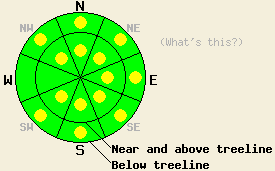
Pockets of MODERATE avalanche danger exist on NW-N-NE-E-SE-S-SW aspects on slopes steeper than 35 degrees due recent snow and moderate to strong winds. Human triggered avalanches will remain possible today. |
|
|
|
Cold weather, northwest winds, and scattered snow showers should continue today due to the upper level trough centered east of the forecast area. The forecast calls for highs in the low teens again today in the mountains. As this trough continues eastward, the scattered clouds and snow showers should diminish. The winds should shift to the northeast tonight before decreasing during the day tomorrow. By tomorrow skies should become mostly sunny and temperatures should begin to warm up into the high teens and low 20's above 7000 ft.
4-8 inches of new, cold, light snow existed on Trimmer Peak yesterday (more info, photos). This new snow rested on top of a mix of old snow surfaces ranging from unconsolidated snow to thin crusts to old wind affected surfaces and small wind slabs. In some areas handpits and snowpit data revealed a thin layer of weak snow just below the near surface crusts and old wind affected surfaces. Even though this weak layer existed below the new snow, neither cracking nor any test slope failures nor unstable results from snowpit tests occurred in non-wind affected areas due to the fact that the new snow showed very few slab characteristics. In these areas ski cuts on test slopes did release loose-dry avalanches involving the new snow (photo). These sluffs did not entrain enough snow to bury a person. On the more wind affected N-NE aspects, the new snow displayed slightly more slab-like traits, and some snowpit tests indicated that soft slab failure could occur in the top foot of the snowpack. Other tests in similar areas showed stable results. One ski cut on an undercut test slope did cause some shooting cracks. Winds remained light in this area yesterday and did not transport much snow (photo).
Avalanche Problem #1: Wind Slabs
Last night the NW winds did increase, and the forecast calls for them remain in the 20-30 mph range for most of today. These NW winds could redistribute snow and form new wind slabs on the E-SE-S-SW aspects. These should stay smaller than the wind slabs that formed during the period of strong SW winds and snowfall on Wed. night but could still pose a problem for backcountry travelers. The wind slabs that formed during Wed. night's storm will also persist on the NW-N-NE-E-SE aspects. Most of these wind slabs should remain less than a foot in depth and not extend very far away from the ridgelines; however, some larger wind slabs up to a couple feet in depth could exist in the most heavily wind loaded areas. Human triggering of both of these kinds of wind slabs will be possible today in pockets of wind loaded terrain. The most fragile wind slabs will exist in near and above treeline complex or extreme terrain in and around steep chutes, gullies, couloirs, cliffs and rock bands.
Avalanche Problem #2: Loose-Dry Avalanches
Human triggered loose-dry avalanches involving the cold, dry snow that fell Wed. night will also remain possible today. These sluffs could occur on any steep slopes where new snow exists especially if the new snow rests on top of an old surface crust. These loose snow sluffs should not entrain enough snow to bury a person, but they could push people into undesirable areas with other consequences.
Pockets of MODERATE avalanche danger exist on NW-N-NE-E-SE-S-SW aspects on slopes steeper than 35 degrees due recent snow and moderate to strong winds. Human triggered avalanches will remain possible today.
| 0600 temperature: | 4-10 deg. F. |
| Max. temperature in the last 24 hours: | 14-18 deg. F. |
| Average wind direction during the last 24 hours: | Northwest |
| Average wind speed during the last 24 hours: | 10-20 mph |
| Maximum wind gust in the last 24 hours: | 40-50 mph |
| New snowfall in the last 24 hours: | O inches |
| Total snow depth: | 64-89 inches |
For 7000-8000 ft: |
|||
| Friday: | Friday Night: | Saturday: | |
| Weather: | Mostly cloudy with a slight chance of snow showers through the day | Partly cloudy with a slight chance of snow showers in the evening | Mostly sunny to partly cloudy |
| Temperatures: | 13 to 20 deg. F. | -3 to 4 deg. F. | 15 to 22 deg. F. |
| Wind direction: | Northwest | Northeast | East |
| Wind speed: | 15-25 mph with gusts to 30 mph | 10-20 mph with gusts to 35 mph decreasing to 25 mph after midnight | 10-15 mph with gusts to 25 mph in the morning |
| Expected snowfall: | O in. | O in. | O in. |
For 8000-9000 ft: |
|||
| Friday: | Friday Night: | Saturday: | |
| Weather: | Mostly cloudy with a slight chance of snow showers through the day | Partly cloudy with a slight chance of snow showers in the evening | Mostly sunny to partly cloudy |
| Temperatures: | 10 to 16 deg. F. | -1 to 6 deg. F. | 13 to 20 deg. F. |
| Wind direction: | Northwest | Northeast | Northwest |
| Wind speed: | 20-30 mph with gusts to 45 mph | 15-25 mph with gusts to 40 mph decreasing to 30 mph after midnight | 15-20 mph with gusts to 30 mph |
| Expected snowfall: | O in. | O in. | O in. |


This website is owned and maintained by the non-profit arm of the Sierra Avalanche Center. Some of the content is updated by the USDA avalanche forecasters including the forecasts and some observational data. The USDA is not responsible for any advertising, fund-raising events/information, or sponsorship information, or other content not related to the forecasts and the data pertaining to the forecasts.

