In partnership with: 
|
January 16, 2013 at 7:59 am |
|
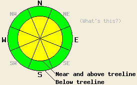
Near and above treeline, avalanche danger is MODERATE on all aspects on slopes steeper than 35 degrees due to recently formed wind slabs resting on a variety of weak layers. Below treeline avalanche danger is LOW. Even in the LOW danger areas unstable snow could still exist on isolated terrain features. |
|
|
|
The east and northeast winds that have buffeted the region for the last several days should start to decrease this afternoon and evening. By tomorrow afternoon the winds should become light. The high pressure ridge over the area will keep skies clear through the weekend. This high pressure ridge should cause temperatures above 7000 ft. to warm up into the 40's today and tomorrow. The forecast calls for colder temperatures in the mountain valleys due to a continued temperature inversion.
Hard wind slabs existed on E-SE-S-SW-W-NW aspects in wind exposed near and above treeline terrain on Relay Peak (photos, videos, more info) and Monument Peak (photos, videos, more info). These wind slabs rested on top of a variety of weaker snow ranging from a layer of soft snow to weak snow above and below a thin melt freeze crust. They ranged in depth from 6 inches in more protected areas to more than 3 ft in the most heavily wind loaded areas. Skier triggered shooting cracks and large collapses occurred on E-SE-S aspects on Relay Peak. Snowpit tests, handpits, and other observations consistently indicated that the weak layers below the wind slabs could still fail and that fractures could travel along those weak layers in both areas. The east winds remained strong enough to transport snow yesterday and continued to build new wind slabs on leeward slopes and to scour the windward slopes. In some areas wind scouring has left firm icy surfaces on the N-NE-E aspects.
Avalanche Problem #1: Wind Slabs
Observations have revealed wind slabs that exhibit signs of instability on all but the NE aspects over the last two days. Human triggered avalanches involving these wind slabs will remain possible today. These slabs rest on top of weak layers (see above) that could break in response to a person on top of the snowpack. The varied weak layers under the slabs, variable wind speeds, and variable amounts of snow available for transport all combine to introduce uncertainty into where the most fragile slabs exist. Due to the hard slab characteristics of these wind slabs they could fracture well above or to the side of the person who triggers the failure. These kind of hard slabs sometimes fail after several people have already put tracks on the slope. Careful snowpack evaluation and observations can help determine if a slope has these wind slabs on it.
Avalanche Problem #2: Loose Wet Avalanches:
Cold snow on the sun-exposed SE-S-SW aspects combined with significant warming and sunshine today will allow some wet snow instabilities to form. Small wet point releases, roller balls, and pinwheels may occur on the most sun exposed aspects especially near trees and rocks. These should remain relatively small due to the low sun angles and short January days and not involve enough snow to bury a person. However, they could still push a person off balance or into areas with undesirable consequences.
Near and above treeline, avalanche danger is MODERATE on all aspects on slopes steeper than 35 degrees due to recently formed wind slabs resting on a variety of weak layers. Below treeline avalanche danger is LOW. Even in the LOW danger areas unstable snow could still exist on isolated terrain features.
| 0600 temperature: | 24-28 deg. F. |
| Max. temperature in the last 24 hours: | 30-33 deg. F. |
| Average wind direction during the last 24 hours: | East Northeast |
| Average wind speed during the last 24 hours: | 35-50 mph |
| Maximum wind gust in the last 24 hours: | 55-81 mph |
| New snowfall in the last 24 hours: | O inches |
| Total snow depth: | 61-86 inches |
For 7000-8000 ft: |
|||
| Wednesday: | Wednesday Night: | Thursday: | |
| Weather: | Sunny | Clear | Sunny |
| Temperatures: | 40-46 deg. F. | 32-38 deg. F. | 40-44 deg. F. |
| Wind direction: | East | Southeast | Southeast |
| Wind speed: | 25-30 mph with gusts to 40 mph decreasing to 15-20 mph with gusts to 30 mph in the afternoon | 10-15 mph with gusts to 25 mph | 10-15 mph decreasing during the day |
| Expected snowfall: | O in. | O in. | O in. |
For 8000-9000 ft: |
|||
| Wednesday: | Wednesday Night: | Thursday: | |
| Weather: | Sunny | Clear | Sunny |
| Temperatures: | 38-44 deg. F. | 31-37 deg. F. | 38-44 deg. F. |
| Wind direction: | East | East | Southeast |
| Wind speed: | 25-35 mph with gusts to 50 mph | 15-20 mph with gusts to 30 mph | 10-15 mph decreasing during the day |
| Expected snowfall: | O in. | O in. | O in. |


This website is owned and maintained by the non-profit arm of the Sierra Avalanche Center. Some of the content is updated by the USDA avalanche forecasters including the forecasts and some observational data. The USDA is not responsible for any advertising, fund-raising events/information, or sponsorship information, or other content not related to the forecasts and the data pertaining to the forecasts.

