In partnership with: 
|
January 18, 2013 at 7:57 am |
|
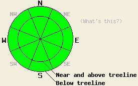
On a regional scale avalanche danger is LOW for all elevations and aspects as human triggered avalanches have become unlikely. Isolated areas of unstable hard wind slabs remain possible in near and above treeline terrain. Normal caution is advised. |
|
|
|
A stable weather pattern persists across the forecast area with clear skies and air temperature inversion. Warm air exists at the mid and upper elevations while cold air remains trapped on the mountain valley floors. Remote sensors are reporting air temperatures above 6,800' in the upper 20s to upper 30s this morning while the mountain valley floors are reporting single digits. Ridgetop winds decreased over the past 24 hours. Wind are forecast to remain light in speed out of the east today, tonight, and tomorrow.
Observations made around the forecast area over the past several days have revealed lingering hard wind slabs formed during recent NE winds and areas of wet surface snow that forms in response to daytime warming. Observations made yesterday on Rose Knob Peak (Mount Rose area) fell right in line with winds slabs in lee areas that continued to show unstable snowpit test results, but were otherwise stubborn and very difficult to trigger. One to three inches of wet surface snow had formed on S-SE aspects by 1 pm, but no significant amount of wet snow instability was observed (photo, more info).
Avalanche Problem #1: Wind Slabs
Wind slabs that formed out of the recent NE wind event linger in near treeline and above treeline areas. Triggering has become difficult and unlikely, but is not impossible. The most well developed wind slabs exist on SW-W-NW aspects. Wind slabs exist sporadically on other aspects as well. NE aspects are the only areas that seem entirely free of wind slabs. These slabs sit on top of thin layers of significantly lower density snow and/or thin melt freeze crust. These slabs are high density, allowing for less than one inch of surface penetration by boots, skis, and snowmobiles. Due to the hard slab characteristics, any avalanches involving these slabs could be triggered once an individual is well out onto the slab, possibly fracturing well above and to the side of the individual. These hard slabs may support the passage of several individuals prior to failing. Even though at this time triggering had become unlikely, the characteristics of this avalanche problem warrant continued caution.
Avalanche Problem #2: Loose Wet Avalanches:
Warm air temperatures around the clock at the mid and upper elevations are keeping overnight snow surface refreeze to a minimum. Refreeze that does occur is reliant entirely on radiational cooling. While a few inches of wet surface snow will form on SE-S-SW aspects in response to daytime warming, minimal instability is expected. The amount of incoming solar radiation and angle of the sun is still fairly low when compared to conditions during the month of March. While isolated loose wet snow avalanches are possible today on SE-S-SW aspects, their size is not expected to pose a significant threat to backcountry travelers.
On a regional scale avalanche danger is LOW for all elevations and aspects as human triggered avalanches have become unlikely. Isolated areas of unstable hard wind slabs remain possible in near and above treeline terrain. Normal caution is advised.
| 0600 temperature: | 32 to 38 deg. F. |
| Max. temperature in the last 24 hours: | 39 to 53 deg. F. |
| Average wind direction during the last 24 hours: | East |
| Average wind speed during the last 24 hours: | 18 mph |
| Maximum wind gust in the last 24 hours: | 29 mph |
| New snowfall in the last 24 hours: | O inches |
| Total snow depth: | 60 to 84 inches |
For 7000-8000 ft: |
|||
| Friday: | Friday Night: | Saturday: | |
| Weather: | Sunny skies. | Clear skies. | Sunny skies. |
| Temperatures: | 43 to 49 deg. F. | On the peaks 25 to 35 deg F. | In the valleys 5 to 15 deg. F. | 43 to 49 deg. F. |
| Wind direction: | E | E | E |
| Wind speed: | 5 to 15 mph in the morning, becoming light. | Light winds becoming 5 to 15 mph after midnight. | 5 to 15 mph in the morning, becoming light. |
| Expected snowfall: | O in. | O in. | O in. |
For 8000-9000 ft: |
|||
| Friday: | Friday Night: | Saturday: | |
| Weather: | Sunny skies. | Clear skies. | Sunny skies. |
| Temperatures: | 43 to 49 deg. F. | 26 to 34 deg. F. | 43 to 49 deg. F. |
| Wind direction: | E | E | E |
| Wind speed: | 10 to 20 mph in the morning, becoming light. | Light winds becoming 10 to 15 mph with gusts to 25 mph after midnight. | 10 to 15 mph with gusts to 25 mph in the morning, becoming light. |
| Expected snowfall: | O in. | O in. | O in. |


This website is owned and maintained by the non-profit arm of the Sierra Avalanche Center. Some of the content is updated by the USDA avalanche forecasters including the forecasts and some observational data. The USDA is not responsible for any advertising, fund-raising events/information, or sponsorship information, or other content not related to the forecasts and the data pertaining to the forecasts.

