In partnership with: 
|
January 20, 2013 at 7:40 am |
|
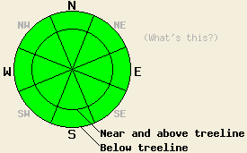
On a regional scale avalanche danger is LOW for all elevations and aspects as human triggered avalanches are unlikely. Isolated areas of unstable hard wind slabs remain possible in near and above treeline terrain. Normal caution is advised. |
|
|
|
Observations made around the forecast area over the past several days have revealed lingering hard wind slabs formed during recent NE winds and areas of wet surface snow that form in response to daytime warming. Observations made yesterday on Tamarack Peak (Mount Rose area) and on the south side of Mt. Lincoln (Donner Summit area) revealed good snowpack stability. Mixed snow surface conditions ranging from cold scoured to cold unconsolidated to wet snow vary by aspect and exposure to previous NE winds (photos, more info). Unconsolidated snow that has yet to undergo a melt freeze cycle has been noted in protected areas below treeline on N and NE aspects in numerous locations around the forecast area. On south aspects, 1 to 3 inches of wet surface snow over supportable melt freeze crust was observed yesterday at 7,800' and at 9,100' at noon.
Avalanche Problem #1: Wind Slabs
Wind slabs that formed out of the recent NE wind event linger in near treeline and above treeline areas. Triggering at this time is difficult and unlikely, but not impossible. The most well developed wind slabs exist on SW-W-NW aspects. Wind slabs exist sporadically on other aspects as well. NE aspects are the only above treeline areas that seem entirely free of wind slabs. These slabs sit on top of thin layers of significantly lower density snow, faceted snow, and/or a thin melt freeze crust. These slabs are high density, allowing for less than one inch of surface penetration by boots, skis, and snowmobiles. Due to the hard slab characteristics, any avalanches involving these slabs could be triggered once an individual is well out onto the slab, possibly fracturing well above and to the side of the individual. These hard slabs may support the passage of several individuals prior to failing. Even though at this time triggering is unlikely, the characteristics of this avalanche problem warrant continued caution.
Avalanche Problem #2: Loose Wet Avalanches:
Air temperatures fell to near or below freezing last night in some mid and upper elevation areas. Other locations remained well above freezing. This is expected to have produced variable amounts of snow surface refreeze at different locations around the forecast area. All areas will have experienced some amount of refreeze due to radiational cooling under clear skies. A few inches of wet surface snow will form on SE-S-SW aspects in response to daytime warming, but minimal instability is expected. The amount of incoming solar radiation and angle of the sun is still fairly low when compared to conditions during the month of March. While isolated loose wet snow avalanches are possible today on SE-S-SW aspects, their size is not expected to pose a significant threat to backcountry travelers.
On a regional scale avalanche danger is LOW for all elevations and aspects as human triggered avalanches are unlikely. Isolated areas of unstable hard wind slabs remain possible in near and above treeline terrain. Normal caution is advised.
| 0600 temperature: | 27 to 41 deg. F. |
| Max. temperature in the last 24 hours: | 45 to 48 deg. F. |
| Average wind direction during the last 24 hours: | East |
| Average wind speed during the last 24 hours: | 18 mph |
| Maximum wind gust in the last 24 hours: | 27 mph |
| New snowfall in the last 24 hours: | O inches |
| Total snow depth: | 59 to 83 inches |
For 7000-8000 ft: |
|||
| Sunday: | Sunday Night: | Monday: | |
| Weather: | Sunny skies. | Clear skies. | Sunny skies. |
| Temperatures: | 44 to 52 deg. F. | 25 to 35 deg. F. | 45 to 53 deg. F. |
| Wind direction: | E | E | E |
| Wind speed: | Up to 10 mph. | Around 10 mph. | Up to 10 mph. |
| Expected snowfall: | O in. | O in. | O in. |
For 8000-9000 ft: |
|||
| Sunday: | Sunday Night: | Monday: | |
| Weather: | Sunny skies. | Clear skies. | Sunny skies. |
| Temperatures: | 38 to 48 deg. F. | 28 to 36 deg. F. | 40 to 50 deg. F. |
| Wind direction: | E | E | E |
| Wind speed: | 10 to 20 mph with gusts to 30 mph. | 10 to 20 mph with gusts to 30 mph. | 10 to 20 mph in the morning, becoming light. |
| Expected snowfall: | O in. | O in. | O in. |


This website is owned and maintained by the non-profit arm of the Sierra Avalanche Center. Some of the content is updated by the USDA avalanche forecasters including the forecasts and some observational data. The USDA is not responsible for any advertising, fund-raising events/information, or sponsorship information, or other content not related to the forecasts and the data pertaining to the forecasts.

