In partnership with: 
|
January 25, 2013 at 7:50 am |
|
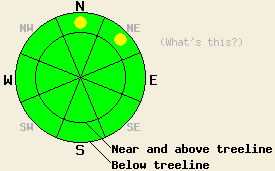
Pockets of MODERATE avalanche danger exist below treeline on N-NE aspects on slopes 35 degrees and steeper. For all other areas, avalanche danger remains LOW. Small loose wet snow avalanches are possible today due to rain on snow. |
|
|
|
The weather forecast for the past 24 hours did not verify well at all. Snow level was forecast to remain below 7,000' and instead rose to 8,900' last night. The forecast high pressure and decrease in precipitation for yesterday evening and last night did not occur, with continued rainfall instead. Rain amounts forecast at 0.1 to 0.2 inches verified in some areas while other areas have received 0.4 to 0.75 inches of rainfall thus far. Ridgetop winds did remain light out of the southwest for most of the past 24 hours, increasing to moderate in speed this morning. For today the forecast calls for an additional 0.05 to 0.1 inches of rainfall with snow level 8,200' to 7,300'. Moderate speed southwest winds are forecast to continue today and become strong tomorrow.
Observations made yesterday on north aspects in the Deep Creek Drainage revealed rain wetted snow in all areas up to the high point of travel at 7,640'. No new snow was evident in this area up to that elevation. Snowpit data showed that the near surface facet layer below the rain wetted surface layer was a weak layer that failed easily. However, propagation for wet slab activity showed as unlikely in both formal and informal tests. Roller balls were triggered off of ski turns on N aspects steeper than 35 degrees at all elevations traveled. A ski cut made at 6,150' on a N aspect 47 degree test slope produced roller balls rather than a loose wet avalanche. This was indicative of general conditions in the area on N aspects (photos, pit profile, more info). On other aspects and at other elevations, the existing snowpack is in good condition to handle rain due to a lack of near surface faceted crystals or other weak layers.
Avalanche Problem #1: Loose wet avalanches
Areas where rainfall that has created wet snow on top of well developed near surface facets remains a concern for today. Low and mid elevation N-NE aspects that were subject to prolonged cold air during the recent period of air temperature inversion hold areas of weak, somewhat sugary snow near the snow surface. In areas where rain is deposited on this weak snow, small loose wet avalanches can occur. The amount of snow involved could be up to 6 inches deep. Areas with terrain traps present a greater hazard. Steep N-NE aspects in below treeline terrain that are below 8,000' are suspect. The weakest areas of near surface facets were observed below 7,600' in the days leading up to the onset of rain.
Avalanche Problem #2: Wet slabs and wind slabs
In very isolated areas a slab avalanche could occur today. A few of the highest elevation areas (above 9,500') near the Sierra Crest may have received enough new snowfall to create wind slabs in above treeline areas. These slabs will exist mainly on N-NE-E aspects. There are very few locations within the forecast area where this issue might exist. An isolated wet slab avalanche is also possible in areas where the near surface facet layer is well developed (N-NE aspects below 7,600') and the higher rainfall amounts of 0.4 to 0.75 inches have occurred. The requirement for areas with both the weakest snow and highest rainfall amounts will again keep this problem isolated to very few locations within the forecast area. On a regional scale, triggering a slab avalanche is unlikely today.
Pockets of MODERATE avalanche danger exist below treeline on N-NE aspects on slopes 35 degrees and steeper. For all other areas, avalanche danger remains LOW. Small loose wet snow avalanches are possible today due to rain on snow.
| 0600 temperature: | 32 to 36 deg. F. |
| Max. temperature in the last 24 hours: | 35 to 40 deg. F. |
| Average wind direction during the last 24 hours: | Southwest |
| Average wind speed during the last 24 hours: | 16 mph |
| Maximum wind gust in the last 24 hours: | 34 mph |
| New snowfall in the last 24 hours: | Snow 0 to 1 inches | Rain 0.1 to 0.75 inches |
| Total snow depth: | 56 to 82 inches |
For 7000-8000 ft: |
|||
| Friday: | Friday Night: | Saturday: | |
| Weather: | Cloudy skies with scattered showers in the morning. A slight chance of rain in the afternoon. | Mostly cloudy skies with a slight chance of rain and snow. | Mostly cloudy skies. A chance of rain and snow, mainly in the afternoon. |
| Temperatures: | 35 to 40 deg. F. | 28 to 34 deg. F. | 34 to 39 deg. F. |
| Wind direction: | SW | SW | SW |
| Wind speed: | 10 to 15 mph with gusts to 25 mph. | 10 to 15 mph with gusts to 25 mph. | 10 to 15 mph, increasing to 15 to 30 mph with gusts to 40 mph in the afternoon. |
| Expected snowfall: | O in. | 0 to trace in. | O in. |
For 8000-9000 ft: |
|||
| Friday: | Friday Night: | Saturday: | |
| Weather: | Cloudy skies with scattered showers in the morning. A slight chance of rain and snow in the afternoon. | Mostly cloudy skies with a slight chance of snow. | Mostly cloudy skies. A chance of snow, mainly in the afternoon. |
| Temperatures: | 32 to 37 deg. F. | 25 to 30 deg. F. | 29 to 34 deg. F. |
| Wind direction: | SW | SW | SW |
| Wind speed: | 10 to 20 mph with gusts to 40 mph. | 15 to 25 mph with gusts to 40 mph. | 20 to 25 mph with gust to 50 mph, increasing to 30 to 45 mph with gusts to 70 mph in the afternoon. |
| Expected snowfall: | 0 to trace in. | 0 to trace in. | 0 to trace in. |


This website is owned and maintained by the non-profit arm of the Sierra Avalanche Center. Some of the content is updated by the USDA avalanche forecasters including the forecasts and some observational data. The USDA is not responsible for any advertising, fund-raising events/information, or sponsorship information, or other content not related to the forecasts and the data pertaining to the forecasts.

