In partnership with: 
|
January 27, 2013 at 8:00 am |
|
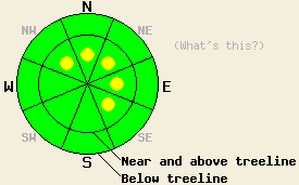
On slopes steeper than 35 degrees, pockets of MODERATE avalanche danger exist on near and above treeline NW-N-NE-E-SE aspects due to newly formed wind slabs resting on frozen rain crusts. Small loose dry snow avalanches may be possible on some steep slopes today due new snow resting on frozen crusts. |
|
|
|
A fast moving low pressure system has brought snow showers and colder temperatures to the region. 2-3 inches of snow fell above 7000 ft last night and another 1-3 inches could accumulate today. Remote sensors above 7000 ft. indicate temperatures in the teens and low 20's. Today's highs should not climb much above those levels. As this system continues eastward today, the snow showers should decrease and the winds should begin shifting to the NE. By tomorrow the snow showers should come to an end. Expect cold temperatures and strong NE winds during the day tomorrow.
Observations yesterday on Fireplug (photo, snowpit, more info) and on Mt. Lincoln (photos, more info) showed evidence of rain up to at least 9200 ft. Colder temperatures and winds had allowed the snowpack to begin the refreezing process. On Mt. Lincoln a 1-2 inch thick, breakable crust had formed above the layer of rain wetted snow on all aspects. Some skier triggered roller balls did occur on a low elevation East aspect on Mt Lincoln. On Fireplug a thick supportable refrozen crust existed on the southerly aspects, while a thin breakable crust existed above 1 inch of cold dry snow on the northerly aspects. A light dusting of new snow had fallen on top of the crusts in the Mt. Rose area.
Avalanche Problem #1: Wind Slabs
New snow and winds strong enough to transport snow should allow wind slabs to form on top of frozen rain crusts in wind loaded areas. For the most part these slabs should remain small due to the limited snowfall amounts. However, some of the new wind slabs could measure 1-2 ft in depth in the most heavily wind loaded areas. Human trigger-able avalanches involving these new wind slabs will become possible today. The largest and most fragile wind slabs will exist on the the most heavily wind loaded N-NE-E aspects in near and above treeline terrain. Some smaller slabs could also exist on cross-loaded NW and SE aspects. As the winds shift to the NE over the next 24 hours small wind slabs will also form on other more typically windward aspects.
Avalanche Problem #2: Loose Dry Avalanches:
The new cold snow may not bond well to the hard frozen rain crusts below it. This combination of cold dry snow on top of a smooth slippery surface will allow small loose snow sluffs to become possible today on steep slopes. This loose snow problem should remain shallow and surficial and not involve enough snow to bury a person. In areas that receive the most new snow, however, a few of these sluffs could change one's course of travel and push one into areas with other consequences.
On slopes steeper than 35 degrees, pockets of MODERATE avalanche danger exist on near and above treeline NW-N-NE-E-SE aspects due to newly formed wind slabs resting on frozen rain crusts. Small loose dry snow avalanches may be possible on some steep slopes today due new snow resting on frozen crusts.
| 0600 temperature: | 12-18 deg. F. |
| Max. temperature in the last 24 hours: | 29-37 deg. F. |
| Average wind direction during the last 24 hours: | Southwest |
| Average wind speed during the last 24 hours: | 30 mph |
| Maximum wind gust in the last 24 hours: | 62 mph |
| New snowfall in the last 24 hours: | 2-3 inches |
| Total snow depth: | 56-83 inches |
For 7000-8000 ft: |
|||
| Sunday: | Sunday Night: | Monday: | |
| Weather: | Snow showers in the morning with snow becoming more scattered and decreasing by the afternoon. | Cloudy with scattered snow showers | Mostly cloudy with a slight chance of snow showers |
| Temperatures: | 20-25 deg. F. | 10-15 deg. F. | 20-25 deg. F. |
| Wind direction: | Northwest | Northeast | East shifting to the north in the afternoon |
| Wind speed: | 15-20 mph with gusts to 30 mph | 10-15 mph | 15-20 mph with gusts to 35 mph increasing to 20-30 mph with gusts to 40 mph in the afternoon |
| Expected snowfall: | 1-3 in. | up to 1 in. | O in. |
For 8000-9000 ft: |
|||
| Sunday: | Sunday Night: | Monday: | |
| Weather: | Snow showers in the morning with snow becoming more scattered and decreasing by the afternoon. | Cloudy with scattered snow showers | Mostly cloudy with a slight chance of snow showers |
| Temperatures: | 14-20 deg. F. | 5-10 deg. F. | 14-20 deg. F. |
| Wind direction: | Northwest | Northeast | Northeast |
| Wind speed: | 20-30 mph with gusts to 45 mph | 20-30 mph with gusts to 45 mph | 35-45 mph with gusts to 70 mph |
| Expected snowfall: | 2-3 in. | up to 1 in. | O in. |


This website is owned and maintained by the non-profit arm of the Sierra Avalanche Center. Some of the content is updated by the USDA avalanche forecasters including the forecasts and some observational data. The USDA is not responsible for any advertising, fund-raising events/information, or sponsorship information, or other content not related to the forecasts and the data pertaining to the forecasts.

