In partnership with: 
|
January 28, 2013 at 7:47 am |
|
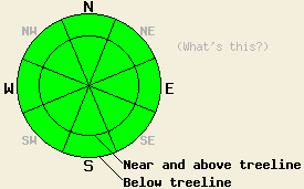
Even though small avalanches could occur today in isolated areas or extreme terrain due to isolated small, shallow wind slabs, the avalanche danger is LOW on all aspects and at all elevations on a regional scale. While the avalanche danger may be LOW, other hazards like long sliding falls on hard icy snow do still exist in the backcountry. |
|
|
|
Yesterday's system moved out of the area faster than expected causing snowfall to end early yesterday morning. Cold and partly cloudy weather similar to yesterday's weather should continue today. A weak low pressure east of the area should allow the northerly winds to increase dramatically over the next 24 hours. The forecast calls for any precipitation associated with this system to remain north and east of the forecast area. By tomorrow afternoon the influence of this low pressure should start to diminish, and a high pressure ridge should begin to build over the region.
Cold, dry, new snow on top of a supportable frozen rain crust created "dust on crust" conditions on most aspects on Powder House Peak (photo, snowpit, more info), on Tamarack Peak (photos, more info), and in Drifter Bowl (photos, snowpit, more info) yesterday. In Drifter Bowl wind loading only created wind slabs a few inches thick that only extended a 1-3 ft down-slope from the ridgelines (photo). Some wind slabs up to 10 inches in depth that only extended a few few feet down-slope did exist on aspects loaded by the N wind on Tamarack Peak yesterday (photo). Some very small loose snow sluffs also occurred in the Mt. Rose area on isolated steep slopes (photo). In all three of these areas, the recent rain crust had refrozen. In the Drifter Bowl area and on the lower elevations on Powder House Peak, this rain crust easily supported the weight of a skier. On Tamarack Peak the rain crust varied from supportable to thin and breakable depending on elevation and aspect.
Avalanche Problem #1: Wind Slabs
Strong northerly winds will cause wind loading on the NW-W-SW-S-SE aspects. Due to the small amount of new snow available for transport any wind slabs that do form should remain small and isolated. In the most heavily wind loaded areas, they may reach around a foot in depth. They should not extend very far down-slope. Human trigger-able failures involving these new wind slabs will become possible today; however, they should not involve enough snow to bury a person. They could knock a person off balance which would create other problems because arresting a fall will be difficult in many areas due to the hard icy surfaces that exist on many slopes.
Avalanche Problem #2: Loose Dry Avalanches:
Cold snow resting on top of hard frozen rain crusts will make small loose snow sluffs possible again today on steep slopes. This loose snow problem should remain shallow and surficial and not involve enough snow to bury a person. In areas that received the most new snow on Saturday night, a few of these sluffs could push a person off course or off his/her feet resulting in other consequences.
Even though small avalanches could occur today in isolated areas or extreme terrain due to isolated small, shallow wind slabs, the avalanche danger is LOW on all aspects and at all elevations on a regional scale. While the avalanche danger may be LOW, other hazards like long sliding falls on hard icy snow do still exist in the backcountry.
| 0600 temperature: | 7-16 deg. F. |
| Max. temperature in the last 24 hours: | 19-23 deg. F. |
| Average wind direction during the last 24 hours: | Northeast |
| Average wind speed during the last 24 hours: | 10-15 mph |
| Maximum wind gust in the last 24 hours: | 30 mph |
| New snowfall in the last 24 hours: | O inches |
| Total snow depth: | 57-83 inches |
For 7000-8000 ft: |
|||
| Monday: | Monday Night: | Tuesday: | |
| Weather: | Partly cloudy with a slight chance of light snow showers north of I-80 | Partly cloudy | Partly cloudy |
| Temperatures: | 12-22 deg. F. | 15-20 deg. F. | 32-37 deg. F. |
| Wind direction: | Northwest to northeast | North | Northwest |
| Wind speed: | 10-20 mph increasing to 15-25 mph with gusts to 40 mph | 15-30 mph with gusts to 50 mph | 15-30 mph with gusts to 50 mph |
| Expected snowfall: | O in. | O in. | O in. |
For 8000-9000 ft: |
|||
| Monday: | Monday Night: | Tuesday: | |
| Weather: | Partly cloudy with a slight chance of light snow showers north of I-80 | Partly cloudy | Partly cloudy |
| Temperatures: | 12-17 deg. F. | 10-16 deg. F. | 27-34 deg. F. |
| Wind direction: | Northeast | North | Northwest |
| Wind speed: | 15-25 mph increasing to 30-40 mph with gusts to 60 mph | 35-45 mph with gusts to 60 mph increasing to 50-55 mph with gusts to 85 mph after midnight | 55-60 mph with gusts to 90 mph decreasing to 40-45 mph with gusts to 75 mph in the afternoon |
| Expected snowfall: | O in. | O in. | O in. |


This website is owned and maintained by the non-profit arm of the Sierra Avalanche Center. Some of the content is updated by the USDA avalanche forecasters including the forecasts and some observational data. The USDA is not responsible for any advertising, fund-raising events/information, or sponsorship information, or other content not related to the forecasts and the data pertaining to the forecasts.

