In partnership with: 
|
January 29, 2013 at 7:53 am |
|
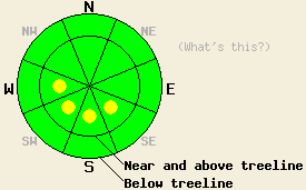
Isolated pockets of MODERATE avalanche danger exist on slopes steeper than 35 degrees on near and above treeline SE-S-SW-W aspects due to NE winds building wind slabs on those aspects. LOW avalanche danger exists on all other aspects. Even though the avalanche danger remains isolated other hazards like long sliding falls on hard icy snow do still exist in the backcountry. |
|
|
|
The northeast wind increased significantly during the night averaging between 30 and 45 mph with gusts between 52 and 81 mph along the ridge tops. These strong northeast winds should continue through this morning as a high pressure ridge builds over the area. By this afternoon the winds should begin decreasing. Tomorrow the forecast calls for ridge top winds in the 15-20 mph range. This high pressure ridge will also bring sunny skies and warmer temperatures back to the region. Today's highs could climb into the low to mid 30's above 7000 ft. and tomorrow's could reach into the upper 30's to low 40's.
Yesterday on Incline Lake Peak, 4-6 inches of cold dry snow existed on top of a supportable rain crust on all aspects. This light snow did not display any slab-like qualities in areas sheltered from the winds (snowpit, more info). On the exposed near and above treeline N-NE aspects, the northeast winds had scoured away much of this light snow leaving behind frozen rain crusts. These winds deposited this snow on the S-SE aspects creating small wind slabs on those aspects. Ski kicks and ski cuts did cause cracking and test slope failures on slopes where these wind slabs existed (photos, more info). The largest of these wind slabs measured 18 inches thick near the ridgeline (photo, more info). The slab thickness decreased quickly as one moved away from the ridgeline becoming less than 6 inches once one moved 3 to 4 ft. away from the ridgeline.
Avalanche Problem #1: Wind Slabs
The wind slabs that formed on the near and above treeline W-SW-S-SE aspects yesterday will have become larger and more widespread due to the continued northerly winds. The largest and most extensive wind slabs will exist in the mountains east of Lake Tahoe where 4-6 inches of snow fell on Sat. night. Some of these wind slabs could have grown to around 2 ft. in depth. These slabs should not extend very far away from ridgelines due to the small amount of snow available for transport. In the most heavily wind loaded areas, human triggered avalanches involving these new wind slabs will be possible today. While most of these kind of avalanches should not involve enough snow to bury a person, terrain traps could allow burial to become possible in isolated areas where the largest slabs exist. The smaller ones could still knock a person off balance which would create other problems because arresting a fall will be difficult in many areas due to the hard icy surfaces that exist on many slopes.
Avalanche Problem #2: Loose Snow Avalanches:
Cold snow resting on top of hard frozen rain crusts and sunny skies with warmer temperatures will make loose snow sluffs, roller balls, and other loose snow instabilities possible again today. This loose snow problem should remain shallow and surficial and not involve enough snow to bury a person. In areas that received the most new snow on Saturday night, a few of these sluffs could push a person off course or off his/her feet resulting in other consequences.
Isolated pockets of MODERATE avalanche danger exist on slopes steeper than 35 degrees on near and above treeline SE-S-SW-W aspects due to NE winds building wind slabs on those aspects. LOW avalanche danger exists on all other aspects. Even though the avalanche danger remains isolated other hazards like long sliding falls on hard icy snow do still exist in the backcountry.
| 0600 temperature: | 25-31 deg. F. |
| Max. temperature in the last 24 hours: | 25-31 deg. F. |
| Average wind direction during the last 24 hours: | Northeast |
| Average wind speed during the last 24 hours: | 10-30 mph |
| Maximum wind gust in the last 24 hours: | 52-81 mph |
| New snowfall in the last 24 hours: | O inches |
| Total snow depth: | 57-83 inches |
For 7000-8000 ft: |
|||
| Tuesday: | Tuesday Night: | Wednesday: | |
| Weather: | Partly cloudy | Clear | Sunny |
| Temperatures: | 32-37 deg. F. | 23-28 deg. F. | 39-44 deg. F. |
| Wind direction: | North | Northeast | East |
| Wind speed: | 15-30 mph with gusts to 50 mph | 10-20 mph with gusts to 35 mph | 10-15 mph in the morning becoming light in the afternoon |
| Expected snowfall: | O in. | O in. | O in. |
For 8000-9000 ft: |
|||
| Tuesday: | Tuesday Night: | Wednesday: | |
| Weather: | Partly cloudy | Clear | Sunny |
| Temperatures: | 27-33 deg. F. | 23-28 deg. F. | 35-40 deg. F. |
| Wind direction: | Northeast | Northeast | Northeast |
| Wind speed: | 25-40 mph with gusts between 55mph and 75 mph | 20-35 mph with gusts to 50 mph decreasing to 15-25 mph with gusts to 35 mph after midnight | 15-20 mph with gusts to 30 mph |
| Expected snowfall: | O in. | O in. | O in. |


This website is owned and maintained by the non-profit arm of the Sierra Avalanche Center. Some of the content is updated by the USDA avalanche forecasters including the forecasts and some observational data. The USDA is not responsible for any advertising, fund-raising events/information, or sponsorship information, or other content not related to the forecasts and the data pertaining to the forecasts.

