In partnership with: 
|
February 9, 2013 at 8:01 am |
|
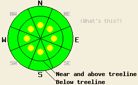
On slopes steeper than 35 degrees, isolated pockets of MODERATE avalanche danger may remain on near and above treeline aspects along the Sierra Crest due wind slabs resting on frozen crusts. Small loose snow avalanches may also be possible on some steep slopes at all elevations today due unconsolidated snow resting on those frozen crusts. |
|
|
|
The snow showers tapered off yesterday and cloud cover started to decrease. As the low continues eastward today the region should see more clearing and increased northeast winds. The forecast calls for winds in the 20-35 mph range through tomorrow. The colder temperatures should also remain over the area with daytime highs in the high teens and mid 20's both today and tomorrow. Another high pressure ridge should begin building over the forecast area and remain for some time.
Yesterday observations on Donner Peak (photos, snowpit, more info) revealed about 4 inches of light and unconsolidated new snow resting on top of a supportable crust. This new snow only displayed slab properties in wind loaded areas on N-NE aspects. In the most heavily wind loaded areas small wind slabs up to 16 inches in depth had formed (photos). These wind slabs quickly diminished in size going down slope and only extended a 3-10 ft down slope. Ski cuts on wind loaded test slopes did cause these newly formed wind slabs to fail. As the slabs moved downhill they also entrained the light unconsolidated snow above the crusts (photo). East of Lake Tahoe on Tamarack Peak only 1-2 inches of new snow had accumulated (photos, snowpit, more info). This small amount of snow did not provide enough material for thick wind slabs to form. Observations from this area indicated that the pittance of new snow also did not add enough load to the snowpack to cause instabilities to form.
Avalanche Concern #1: Wind Slabs
Small wind slabs that extend short distances downslope do exist on some leeward aspects. Most of these slabs should not hold enough snow to bury a person. In the most heavily wind loaded areas that received the most new snow, some isolated larger wind slabs formed. These slabs reside on top of firm crusts that make very efficient bed surfaces. Many of these crusts have thin layers of weak snow around them. Human triggering of these wind slabs will remain possible today. The largest and most fragile wind slabs will exist on the most heavily wind loaded NW-N-NE-E-SE aspects along the Sierra Crest in areas that received the highest snowfall amounts. Smaller wind slabs could form today on other aspects as the northeast winds increase and begin transporting more snow.
Avalanche Problem #2: Loose Dry Avalanches:
The combination of cold dry snow on top of a smooth slippery surface will allow small loose snow sluffs to remain possible on steep slopes today. This loose snow problem should remain shallow and surficial and not involve enough snow to bury a person. In areas that received the most new snow, a few of these sluffs could change one's course of travel and push one into areas with other consequences.
On slopes steeper than 35 degrees, isolated pockets of MODERATE avalanche danger may remain on near and above treeline aspects along the Sierra Crest due wind slabs resting on frozen crusts. Small loose snow avalanches may also be possible on some steep slopes at all elevations today due unconsolidated snow resting on those frozen crusts.
| 0600 temperature: | 8-13 deg. F. |
| Max. temperature in the last 24 hours: | 12-22 deg. F. |
| Average wind direction during the last 24 hours: | Northeast |
| Average wind speed during the last 24 hours: | 15-30 mph |
| Maximum wind gust in the last 24 hours: | 48-65 mph |
| New snowfall in the last 24 hours: | Trace inches |
| Total snow depth: | 58-81 inches |
For 7000-8000 ft: |
|||
| Saturday: | Saturday Night: | Sunday: | |
| Weather: | Mostly sunny | Mostly clear | Mostly sunny |
| Temperatures: | 21-28 deg. F. | 10-18 deg. F. | 21-28 deg. F. |
| Wind direction: | Northeast | Northeast | Northeast |
| Wind speed: | 15-25 mph with gusts to 35 mph | 20-30 mph with gusts to 45 mph | 20-30 mph with gusts to 45 mph |
| Expected snowfall: | O in. | O in. | O in. |
For 8000-9000 ft: |
|||
| Saturday: | Saturday Night: | Sunday: | |
| Weather: | Mostly sunny | Mostly clear | Mostly sunny |
| Temperatures: | 19-25 deg. F. | 11-17 deg. F. | 15-22 deg. F. |
| Wind direction: | Northeast | Northeast | Northeast |
| Wind speed: | 20-30 mph with gusts to 45 mph | 25-35 mph with gusts to 55 mph | 25-35 mph with gusts to 55 mph |
| Expected snowfall: | O in. | O in. | O in. |


This website is owned and maintained by the non-profit arm of the Sierra Avalanche Center. Some of the content is updated by the USDA avalanche forecasters including the forecasts and some observational data. The USDA is not responsible for any advertising, fund-raising events/information, or sponsorship information, or other content not related to the forecasts and the data pertaining to the forecasts.

