In partnership with: 
|
February 20, 2013 at 8:02 am |
|
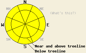
MODERATE avalanche danger exists on all aspects on slopes 35 degrees and steeper due to a combination of strong shifting winds, new snow, and new as well as old weak layers. Human triggered avalanche will remain possible today. The largest and most fragile snow will exist on wind loaded near and above treeline slopes along the Sierra Crest. Most other avalanche activity shoud remain small due to the limited accumulation amounts. |
|
|
|
The snowfall tapered off and the winds shifted to the northeast overnight as the low pressure associated with this storm continues to move east. Storm totals across the forecast area measure 4-9 inches along the Sierra Crest with the highest amounts recorded in the southern part of the forecast area. North and east of Lake Tahoe snowfall only amounted to about 2 inches. Areas even a small distance from the Sierra Crest received significantly less snow. A small high pressure moving over the area today should bring some clearing and allow the northeast winds to continue. As this high pressure moves away tonight more clouds and scattered snow showers that do not produce much accumulation should return to the mountains. The forecast calls for this unsettled weather to continue through tomorrow. Temperatures should remain cold but also begin a gradual warming trend over the next 48 hours.
Yesterday snowfall rates and accumulations increased as one neared the Sierra Crest. In the Lincoln Ridge area near Yuba Pass, 4-6 inches of new snow rested on top of the old snow surfaces. 3-4 inches of that new snow fell during day between 10am -2pm. On many of the NW-N-NE aspects, this new snow existed on top of a rain crust with a layer of weak sugary snow below the crust. Observations across the forecast area have noted this crust/facet combination in many other places as well. In some areas on Lincoln Ridge, a layer of weak snow also existed above the rain crust with a thin intermittent melt-freeze crust above it. Tests on the interface between these old snow surfaces and the new snow and on the older weak layers near those crusts indicated that the new snow had not overloaded these older layers as of 1pm yesterday. A density change between yesterday's snow and the snow that fell during the night of the 18th did react to snowpit tests and ski cuts. Several shooting cracks occurred as this interface failed, and some wind loaded NE facing test slopes also failed at this interface. The most recent snow had formed a 2-8 inch soft slab on these test slopes (photos and more info from Lincoln Ridge).
Avalanche Problem #1: Wind Slabs
The strong winds and new snow associated with this storm have formed wind slabs above a mix of crusts and old weak snow. The changing conditions during this storm also created weaknesses within the storm snow. This combination wind slabs and potential weak layers will allow human triggered avalanches involving these wind slabs to remain possible today. Fragile slabs could reside on the SW wind loaded NW-N-NE-E-SE aspects or could also exist on the W-SW-S aspects due to wind loading from the NE winds. In areas where limited snow accumulated, these slabs should remain small and shallow. Some larger wind slabs 1-3 ft thick could exist in the most heavily wind-loaded areas along the Sierra Crest.
Avalanche Problem #2: Storm Slabs
Some small soft storm slab avalanche activity could also occur in below treeline and near treeline areas where wind loading has not occurred. Weaknesses within the new snow represent the most likely failure plane for these kinds of avalanches; however, some of them could also fail on the older crusts and older weak snow around those crusts. While they may be possible for humans to trigger, these soft storm slabs should remain relatively small due to limited snow accumulations in below treeline areas and in areas away from the Sierra Crest.
Avalanche Problem, #3: Loose Dry Avalanches
In areas where new snow exists on steep slopes, loose dry avalanches will also remain possible today. Loose dry avalanches could be long running in steep areas where they slide on widespread smooth crusts.
MODERATE avalanche danger exists on all aspects on slopes 35 degrees and steeper due to a combination of strong shifting winds, new snow, and new as well as old weak layers. Human triggered avalanche will remain possible today. The largest and most fragile snow will exist on wind loaded near and above treeline slopes along the Sierra Crest. Most other avalanche activity shoud remain small due to the limited accumulation amounts.
| 0600 temperature: | 12-17 deg. F. |
| Max. temperature in the last 24 hours: | 14-22 deg. F. |
| Average wind direction during the last 24 hours: | Southwest shifting to the northeast overnight |
| Average wind speed during the last 24 hours: | Southwest: 30-35 mph | Northeast: 15-25 mph |
| Maximum wind gust in the last 24 hours: | 57 mph |
| New snowfall in the last 24 hours: | Along the Sierra Crest: 4-6 inches |
| Total snow depth: | 59-83 inches |
For 7000-8000 ft: |
|||
| Wednesday: | Wednesday Night: | Thursday: | |
| Weather: | Partly cloudy with some isolated snow showers | Mostly cloudy with isolated snow showers after midnight | Mostly cloudy with isolated snow showers in the morning |
| Temperatures: | 18-25 deg. F. | 5-12 deg. F. | 23-29 deg. F. |
| Wind direction: | Northeast | North | Northeast |
| Wind speed: | 15-25 mph with gusts to 35 mph | 15-20 mph with gusts to 30 mph becoming light after midnight | 15-20 mph with gusts to 30 mph |
| Expected snowfall: | O in. | O in. | O in. |
For 8000-9000 ft: |
|||
| Wednesday: | Wednesday Night: | Thursday: | |
| Weather: | Partly cloudy with some isolated snow showers | Mostly cloudy with isolated snow showers after midnight | Mostly cloudy with isolated snow showers in the morning |
| Temperatures: | 17-23 deg. F. | 1-8 deg. F. | 16-22 deg. F. |
| Wind direction: | Northeast | North | Northeast |
| Wind speed: | 25-35 mph with gusts to 50 mph | 15-25 mph with gusts to 40 mph decreasing to 30 mph after midnight | 20-30 mph with gusts to 35 mph increasing to 45 mph in the afternoon |
| Expected snowfall: | O in. | O in. | O in. |


This website is owned and maintained by the non-profit arm of the Sierra Avalanche Center. Some of the content is updated by the USDA avalanche forecasters including the forecasts and some observational data. The USDA is not responsible for any advertising, fund-raising events/information, or sponsorship information, or other content not related to the forecasts and the data pertaining to the forecasts.

