In partnership with: 
|
February 22, 2013 at 8:00 am |
|
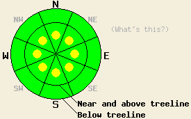
In near and above treeline terrain, some pockets of MODERATE avalanche danger may still linger on all aspects on slopes 35 degrees and steeper where wind slabs rest on weak snow. Human triggered avalanches will remain possible today in these areas. Below treeline the avalanche danger remains LOW even though some small loose snow instabilities may still continue. |
|
|
|
The small high pressure over the area should keep today's weather sunny and allow for warmer temperatures than previous days. The winds should shift to the west and southwest, and cloud cover should start to increase this afternoon and evening as a cold front makes its way towards the region. The bulk of the low pressure associated with this front should remain north of the forecast area. In this area its main effects will be increased clouds, increased southwest winds, and decreased temperatures. The forecast calls for west and southwest winds in the 50-65 mph range along the ridgetops by tomorrow. Some scattered snow showers may occur tonight and tomorrow, but they should not produce any significant accumulation.
Yesterday on Jake's Peak (videos, photo, more info) the depth of recent snow varied greatly with elevation. Above 7600 ft. 4-7 inches of soft recent snow existed, and below that level only 1-2 inches had accumulated. Above 7600 ft. snowpit data from sheltered N-NE aspects still indicated two potential weak layers in the top foot of the snowpack: a density change within the recent snow and a layer of weak sugary snow below the old rain crust at the base of the recent snow. Tests on these layers indicated that if they do break fractures should not travel very far along the either of the layers (videos, more info). In more exposed near and above treeline terrain the recent NE winds had stripped many of the most exposed slopes back to the old rain crust. Some small wind slabs did still remain on near and above treeline NW-N aspects that did not experience as much NE wind. Small wind slabs also existed on some wind loaded S-SW-W aspects in this area. Ski cuts and kicks on these wind slabs did cause small test slope failures and small shooting cracks (photos, more info). The largest wind slabs observed yesterday measured 6-8 inches in depth and only extended 10-15 ft downslope.
Avalanche Problem #1: Wind Slabs
Wind slabs still exist on a variety of aspects due to the shifting winds during the recent storm. Below these slabs a layer of softer low density snow exists with a mix of crusts and old weak sugary snow below that. Tests and observations have shown these slabs remain sensitive to human triggering in some places. In other areas these slabs have started to bond to the snow below them. Some fragile slabs may still lurk on the S-SW-W aspects due to wind loading from the NE winds or on the SW wind loaded NW-N-NE-E-SE aspects. Steep, near and above treeline extreme and complex terrain like gullies, couloirs, and cliffy areas with unsupported slopes will hold the most unstable slabs today. Most of these slabs are small, shallow, and do not hold enough snow to bury a person due to limited snow accumulated or significant wind scouring. In the most heavily wind loaded areas along the Sierra Crest some larger wind slabs 1-3 ft thick could still exist.
Avalanche Problem, #2: Loose Avalanches
In areas where new snow exists on steep slopes, loose dry avalanches will also remain possible today. Loose dry avalanches could be long running in steep areas where they slide on smooth crusts. Some loose wet instabilities like roller balls, pin wheels, and point releases may also form on the most sun exposed southerly aspects today due to warmer temperatures and sunny skies. These loose snow instabilities should remain small and not entrain enough snow to bury a person.
In near and above treeline terrain, some pockets of MODERATE avalanche danger may still linger on all aspects on slopes 35 degrees and steeper where wind slabs rest on weak snow. Human triggered avalanches will remain possible today in these areas. Below treeline the avalanche danger remains LOW even though some small loose snow instabilities may still continue.
| 0600 temperature: | 18-25 deg. F. |
| Max. temperature in the last 24 hours: | 21-29 deg. F. |
| Average wind direction during the last 24 hours: | North and northeast |
| Average wind speed during the last 24 hours: | 10-15 mph |
| Maximum wind gust in the last 24 hours: | 37-48 mph |
| New snowfall in the last 24 hours: | O inches |
| Total snow depth: | 58-83 inches |
For 7000-8000 ft: |
|||
| Friday: | Friday Night: | Saturday: | |
| Weather: | Mostly sunny with some clouds developing later this afternoon | Mostly cloudy with a chance of isolated snow showers | Mostly cloudy with a slight chance of scattered snow showers in the morning. Snow showers becoming more unlikely in the afternoon |
| Temperatures: | 34-39 deg. F. | 20-25 deg. F. | 30-35 deg. F. |
| Wind direction: | North | West | Southwest shifting to the west in the afternoon |
| Wind speed: | 10-15 mph | 15-25 mph with gusts to 30 mph | 15-25 mph with gusts to 40 mph decreasing to 10-15 mph with gusts to 25 mph in the afternoon |
| Expected snowfall: | O in. | O in. | O in. |
For 8000-9000 ft: |
|||
| Friday: | Friday Night: | Saturday: | |
| Weather: | Mostly sunny with some clouds developing later this afternoon | Mostly cloudy with a chance of isolated snow showers | Mostly cloudy with a slight chance of scattered snow showers in the morning. Snow showers becoming more unlikely in the afternoon |
| Temperatures: | 26-34 deg. F. | 18-23 deg. F. | 20-30 deg. F. |
| Wind direction: | North | West | Southwest shifting to the west in the afternoon |
| Wind speed: | 15-25 mph with gusts to 35 mph | 30-40 mph with gusts to 55 mph increasing to 45-60 mph with gusts to 80 mph after midnight | 50-65 mph with gusts to 95 mph decreasing to 15-25 mph with gusts to 40 mph in the afternoon |
| Expected snowfall: | O in. | O in. | O in. |


This website is owned and maintained by the non-profit arm of the Sierra Avalanche Center. Some of the content is updated by the USDA avalanche forecasters including the forecasts and some observational data. The USDA is not responsible for any advertising, fund-raising events/information, or sponsorship information, or other content not related to the forecasts and the data pertaining to the forecasts.

