In partnership with: 
|
February 23, 2013 at 7:50 am |
|
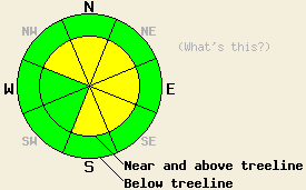
Near and above treeline, avalanche danger is MODERATE on NW-N-NE-E-SE-S aspects on slopes 35 degrees and steeper due to a new round of wind slab formation that occurred last night. For all other areas, avalanche danger is LOW. The greatest areas of instability are expected near and along the Sierra Crest. |
|
|
|
A strong cold front is moving through the forecast area this morning. This is a major wind event with little snowfall expected. Zero to trace amounts of snowfall are expected for most of the forecast area. Up to a half inch of snowfall is possible for areas north of I-80. Ridgetop winds shifted from northeast to southwest early yesterday afternoon. Winds increased to gale force in strength with gusts to 80+ mph last night and this morning. Winds are forecast to shift to the northwest this afternoon and decrease to moderate speed. A second round of strong to gale force wind is forecast to occur tonight into tomorrow morning after ridgetop winds shift to the northeast. Maximum daytime air temperatures for today will occur within a couple hours of sunrise before cold front passage lowers air temperatures 5 to 10 degrees for most locations.
Observations made yesterday on Tamarack Peak (Mount Rose area) and on Meiss Ridge (Carson Pass area) gave indications of mostly stable snowpack conditions. On Tamarack Peak, a few tiny and inconsequential wind slabs were observed in near and above treeline terrain on SE-S-SW aspects. These slabs were not large enough to pose a threat to backcountry travelers (photos, pit profile). On Meiss Ridge, good stabilization of wind slabs that were very unstable two days prior on above treeline SW aspects was evident in both formal and informal observations (video, photos, pit profile).
The big story was the amount of snow on the ground available for wind transport yesterday afternoon by building SW winds. On Meiss Ridge, most SW-W aspects in above treeline terrain held 6 to 8 inches of snow available for wind transport. Isolated areas held 1 to 2 feet of snow available for transport. By 2 pm, ski tracks from 2 hours prior on a low angle S aspect above treeline had already started to fill in with transported snow (photo). Other recent observations have shown that significantly less snow was available for wind transport in areas further east of the Sierra Crest.
Avalanche Problem #1: Wind Slabs
Strong to gale force winds last night and this morning will have scoured available snow from S-SW-W aspects. A new round of direct wind loading and cross loading has occurred in near and above treeline areas. New wind slabs exist in lee areas, mainly on NW-N-NE-E-SE-S aspects. Areas closest to the Sierra Crest had the most snow available for wind transport and will have the deepest wind slabs today. Slab size is expected to decrease significantly in areas further east of the Sierra Crest.
Near and above treeline, avalanche danger is MODERATE on NW-N-NE-E-SE-S aspects on slopes 35 degrees and steeper due to a new round of wind slab formation that occurred last night. For all other areas, avalanche danger is LOW. The greatest areas of instability are expected near and along the Sierra Crest.
| 0600 temperature: | 20 to 26 deg. F. |
| Max. temperature in the last 24 hours: | 33 to 42 deg. F. |
| Average wind direction during the last 24 hours: | Northeast shifting to southwest |
| Average wind speed during the last 24 hours: | NE 11 mph | SW 40 mph |
| Maximum wind gust in the last 24 hours: | NE 26 mph | SW 80 mph |
| New snowfall in the last 24 hours: | 0 to trace inches |
| Total snow depth: | 57 to 81 inches |
For 7000-8000 ft: |
|||
| Saturday: | Saturday Night: | Sunday: | |
| Weather: | Mostly cloudy skies with scattered snow showers in the morning. Isolated snow showers in the afternoon. | Partly cloudy skies. | Partly cloudy skies. |
| Temperatures: | 25 to 30, falling by late morning to 20 to 25 deg. F. | 6 to 16 deg. F. | 27 to 35 deg. F. |
| Wind direction: | SW shifting to NW | NE to E | E |
| Wind speed: | 15 to 25 mph with gusts to 40 mph, shifting and decreasing to 10 to 15 mph with gusts to 25 mph in the afternoon. | 10 to 15 mph with gusts to 25 mph, increasing to 15 to 25 mph with gusts to 40 mph after midnight. | 15 to 25 mph with gusts to 40 mph, decreasing to 10 to 15 mph with gusts to 25 mph in the afternoon. |
| Expected snowfall: | 0 to 0.5 in. | O in. | O in. |
For 8000-9000 ft: |
|||
| Saturday: | Saturday Night: | Sunday: | |
| Weather: | Mostly cloudy skies with scattered snow showers in the morning. Isolated snow showers in the afternoon. | Partly cloudy skies. | Partly cloudy skies. |
| Temperatures: | 20 to 25, falling by late morning to 10 to 20 deg. F. | 4 to 11 deg. F. | 26 to 34 deg. F. |
| Wind direction: | W shifting to NW | NE to E | E |
| Wind speed: | 55 to 70 mph with gusts to 95 mph, shifting and decreasing to 20 to 25 mph with gusts to 40 mph in the afternoon. | 15 to 20 mph with gusts to 35 mph, increasing to 40 to 50 mph with gusts to 70 mph after midnight. | 40 to 50 mph with gusts to 70 mph, decreasing to 15 to 25 mph with gusts to 35 mph in the afternoon. |
| Expected snowfall: | 0 to 0.5 in. | O in. | O in. |


This website is owned and maintained by the non-profit arm of the Sierra Avalanche Center. Some of the content is updated by the USDA avalanche forecasters including the forecasts and some observational data. The USDA is not responsible for any advertising, fund-raising events/information, or sponsorship information, or other content not related to the forecasts and the data pertaining to the forecasts.

