In partnership with: 
|
March 3, 2013 at 7:57 am |
|
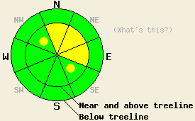
Near and above treeline, areas of MODERATE avalanche danger will develop this morning as new wind slabs form on the most heavily wind loaded NW-N-NE-E-SE aspects on slopes 35 degrees and steeper. For all other areas, avalanche danger remains LOW. In low elevation areas where rain continues to fall today, isolated loose wet snow avalanches are possible on slopes 37 degrees and steeper. |
|
|
|
A weak weather system is passing through the forecast area this morning. Precipitation began around midnight last night for most locations within the forecast area. Snow level began around 7,800' and has fallen to around 6,200' to 6,500' this morning. Snow level may rise up to around 6,800' later this morning before the end of precipitation. For areas above 7,000' new snow amounts of a trace to 2 inches have occurred thus far. An additional 2 to 4 inches is forecast to accumulate today, mainly during the morning hours.
Observations made yesterday in Horse Canyon (Bear Valley area) revealed a very stable snowpack that is in very good condition to handle new snow loading today. Widespread melt-freeze conditions were observed in areas below 8,000'. Wet surface snow of 1 to 3 inches was noted in many areas including sun exposed northerly aspects. No evidence of wet snow instability was observed in the 7,000' to 8,000' elevation range. In near and above treeline areas where old surface wind slabs existed the slabs were stable and well bonded to the snow below. This matched well with other recent observations from around the forecast area indicating that old wind slabs were either well bonded to the snow layers below or too thin to present a hazard concern if poorly bonded (pit profiles, photos, videos, more info).
Avalanche Problem #1: Wind Slabs
As snowfall continues to occur today, winds slabs will form in the most heavily wind loaded near and above treeline areas. This will mainly occur on directly wind loaded N-NE-E aspects as well as on some cross loaded NW and SE aspects. For the most part there is little snow available for building these wind slabs, but in the areas that receive the upper end of forecast snowfall amounts today, the available 6 inches of new snow could contribute to slab formation 1 to 2 feet thick. With fairly low hourly snowfall rates expected today, slabs will build slowly. Natural avalanche activity will remain unlikely today, but human triggered avalanches are possible.
Avalanche Problem #2: Loose Wet Snow Avalanches
Snow levels may rise a few hundred feet later this morning as daytime warming begins. For areas below 6,800' to 7,000' periods of rainfall are possible today if snowfall intensity does not push down enough cold air to keep snow level at or below 6,500'. In areas were rain falls on a mix of old and new snow, small loose wet snow avalanches could occur. On slopes 37 degrees and steeper, small human triggered loose wet snow avalanches might occur as well as an isolated natural avalanche.
Near and above treeline, areas of MODERATE avalanche danger will develop this morning as new wind slabs form on the most heavily wind loaded NW-N-NE-E-SE aspects on slopes 35 degrees and steeper. For all other areas, avalanche danger remains LOW. In low elevation areas where rain continues to fall today, isolated loose wet snow avalanches are possible on slopes 37 degrees and steeper.
| 0600 temperature: | 27 to 31 deg. F. |
| Max. temperature in the last 24 hours: | 40 to 48 deg. F. |
| Average wind direction during the last 24 hours: | Southwest |
| Average wind speed during the last 24 hours: | 32 mph |
| Maximum wind gust in the last 24 hours: | 54 mph |
| New snowfall in the last 24 hours: | Trace to 2 inches |
| Total snow depth: | 53 to 78 inches |
For 7000-8000 ft: |
|||
| Sunday: | Sunday Night: | Monday: | |
| Weather: | Cloudy skies with snow. | Mostly cloudy skies becoming partly cloudy. Scattered snow showers in the evening. | Sunny skies. |
| Temperatures: | 33 to 37 deg. F. | 22 to 27 deg. F. | 40 to 45 deg. F. |
| Wind direction: | SW to W | N | SW |
| Wind speed: | 10 to 20 mph with gusts to 35 mph, decreasing to 10 to 15 mph with gusts to 25 mph in the afternoon. | 10 to 15 mph in the evening becoming light. | Light winds |
| Expected snowfall: | 2 to 3 in. | 0 to trace in. | O in. |
For 8000-9000 ft: |
|||
| Sunday: | Sunday Night: | Monday: | |
| Weather: | Cloudy skies with snow. | Mostly cloudy skies becoming partly cloudy. Scattered snow showers in the evening. | Sunny skies. |
| Temperatures: | 28 to 33 deg. F. | 22 to 27 deg. F. | 36 to 42 deg. F. |
| Wind direction: | SW to W | N shifting to E | SW |
| Wind speed: | 25 to 35 mph with gusts to 55 mph, decreasing to 15 to 20 mph with gusts to 35 mph in the afternoon. | 20 to 25 mph with gusts to 40 mph, shifting and decreasing to 10 to 15 mph with gusts to 25 mph after midnight. | 10 to 15 mph |
| Expected snowfall: | 2 to 4 in. | 0 to trace in. | O in. |


This website is owned and maintained by the non-profit arm of the Sierra Avalanche Center. Some of the content is updated by the USDA avalanche forecasters including the forecasts and some observational data. The USDA is not responsible for any advertising, fund-raising events/information, or sponsorship information, or other content not related to the forecasts and the data pertaining to the forecasts.

