In partnership with: 
|
March 5, 2013 at 8:00 am |
|
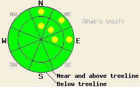
Pockets of MODERATE avalanche danger exist on the N-NE-E aspects above 7500 ft. Above treeline small winds slabs have started to form and below treeline small human-triggered loose snow avalanches remain possible in these areas on slopes 35 degrees and steeper. The avalanche danger will increase as more snow and wind impact the region tonight and tomorrow. |
|
|
|
The southwest winds started to increase last night ahead of a strong low pressure system headed this way. Some cloud cover should also move into the region today ahead of the main storm associated with this system. The forecast calls for this storm to bring 8-14 inches of new snow to the mountains above 7000 ft over the next 24 hrs. Snowfall should start tonight with the most intense period of accumulation occurring late tonight through tomorrow morning. The winds should also peak during that time. By tomorrow afternoon the winds and snow should start to decrease. The cold front accompanying this storm should keep temperatures in the 20's for tonight and tomorrow. For more details on the this storm check in with the Reno NWS.
Yesterday on observations on Freel Peak (photos, snowpit, more info) and Jake's Peak (photos, video, more info) did not reveal many signs of serious instabilities. Observers reported small wind slabs less than 2 inches thick in a few isolated exposed above treeline areas of Freel Peak. The new snow in both of these areas remained soft and unconsolidated and did not display any slab characteristics except in those few spots on Freel. Snowpit data from both areas showed some weak snow near the old rain crust; however, snowpit tests indicated that even if these layers break the resulting fractures should not travel very far. On Jake's Peak ski cuts on steep N-NE aspects did trigger some small loose dry snow sluffs. On the SE-S aspects on Jake's Peak some small roller balls formed near exposed rocks and ski cuts on steep test slopes produced small loose wet sluffs. No evidence of wet snow instabilities existed on Freel Peak.
Avalanche Problem #1: Wind Slabs
As the winds increased last night they started to transport the soft snow that still existed on many SW-W-NW aspects over to the N-NE-E aspects. This wind loading has allowed small wind slabs to begin forming on those aspects. These new wind slabs will exist above a layer of soft unconsolidated snow that could serve as a weak layer. Human-triggered avalanches resulting from the failure of these wind slabs will become possible today. These kind of avalanches should remain small due to the small amount of snow available for transport. Most of these slabs should not hold enough snow to bury a person; however, some of the larger ones could carry enough snow to knock a person off course or into a terrain trap. As more snow and wind impact the region tonight and tomorrow these slabs will quickly increase in size and distribution.
Avalanche Problem #2: Loose Snow Avalanches
Unconsolidated snow on the NW-N-NE aspects will allow human-triggered loose dry snow avalanches to continue today on slopes steeper than 37 degrees. These should remain small and not involve enough snow to bury a person. Some of these sluffs could entrain enough snow to knock a person off his/her feet or push people into terrain traps.
Pockets of MODERATE avalanche danger exist on the N-NE-E aspects above 7500 ft. Above treeline small winds slabs have started to form and below treeline small human-triggered loose snow avalanches remain possible in these areas on slopes 35 degrees and steeper. The avalanche danger will increase as more snow and wind impact the region tonight and tomorrow.
| 0600 temperature: | 26-30 deg. F. |
| Max. temperature in the last 24 hours: | 36-44 deg. F. |
| Average wind direction during the last 24 hours: | Southwest |
| Average wind speed during the last 24 hours: | Before 8pm last night: 5-10 mph | after 8pm last night: 25-35 mph |
| Maximum wind gust in the last 24 hours: | 71 mph |
| New snowfall in the last 24 hours: | O inches |
| Total snow depth: | 54-82 inches |
For 7000-8000 ft: |
|||
| Tuesday: | Tuesday Night: | Wednesday: | |
| Weather: | Mostly cloudy with a slight chance of snow showers in the afternoon | Cloudy with a slight chance of snow showers in the evening. Snow becoming widespread after midnight. | Snow in the morning decreasing to snow showers in the afternoon |
| Temperatures: | 36-43 deg. F. | 20-27 deg. F. | 24-31 deg. F. |
| Wind direction: | Southwest | Southwest | Southwest |
| Wind speed: | 20-35 mph with gusts to 45 mph increasing to 25-40 mph with gusts to 55 mph in the afternoon | 30-40 mph with gusts to 65 mph | 35-40 mph with gusts to 60 mph decreasing to 25-30 mph with gusts to 45 mph in the afternoon |
| Expected snowfall: | O in. | 1-3 in. | 3-8 in. |
For 8000-9000 ft: |
|||
| Tuesday: | Tuesday Night: | Wednesday: | |
| Weather: | Mostly cloudy with a slight chance of snow showers in the afternoon | Cloudy with a slight chance of snow showers in the evening. Snow becoming widespread after midnight. | Snow in the morning decreasing to snow showers in the afternoon |
| Temperatures: | 28-36 deg. F. | 19-24 deg. F. | 18-24 deg. F. |
| Wind direction: | Southwest | Southwest | Southwest |
| Wind speed: | 45-50 mph with gusts to 75 mph increasing to 55-60 mph with gusts to 85 mph in the afternoon | 60-70 mph with gusts to 100 mph | 55-60 mph with gusts to 95 mph decreasing to 45-50 mph with gusts to 75 mph in the afternoon |
| Expected snowfall: | O in. | 1-3 in. | 4-8 in. |


This website is owned and maintained by the non-profit arm of the Sierra Avalanche Center. Some of the content is updated by the USDA avalanche forecasters including the forecasts and some observational data. The USDA is not responsible for any advertising, fund-raising events/information, or sponsorship information, or other content not related to the forecasts and the data pertaining to the forecasts.

