In partnership with: 
|
March 8, 2013 at 7:47 am |
|
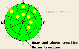
Near and above treeline, avalanche danger is LOW with pockets of MODERATE danger on NW-N-NE-E-SE aspects on slopes steeper than 35 degrees due to lingering wind slabs. Below treeline, avalanche danger is LOW with pockets of MODERATE danger on NW-N-NE aspects on slopes steeper than 35 degrees due to lingering storm slabs. Areas of unstable snow will exist within surrounding areas of stable snow. |
|
|
|
Continued low pressure over the region will keep the trend of cloud cover and light snow showers ongoing across the forecast area today. Snow shower activity is forecast to end tonight with building high pressure and sunny skies over the weekend. Snow showers over the past 24 hours deposited an additional 1 to 3 inches of new snow in areas above 7,000'. This brings above 7,000' snow totals up to 10 to 15 inches over the past 52 hours. Ridgetop winds were calm to light in speed yesterday with variable direction. Light northeast ridgetop winds are forecast for today. Forecast wind speeds are too slow to redistribute snow on the ground. Air temperatures this morning above 8,000' are in the upper teens to low 20s. Maximum daytime air temperatures are forecast to warm into the upper teens to low 30s today for areas above 7,000'.
Two separate reports of audible collapse (whumphing) that occurred yesterday were received from Tamarack Peak (Mount Rose area) in wind protected below treeline terrain on northerly aspects. No shooting cracks were observed, but a low density layer of snow at the base of the storm snow was identified as the weak layer. This matches well with observations of unstable storm slabs made on Wednesday in the Donner Summit, Pole Creek, and Carson Pass areas (videos. photos, pit profiles, more info).
Yesterday on Hidden Peak (West Shore Tahoe area) better snowpack stability was observed in wind protected areas below treeline. The low density weak layer at the base of the storm snow was notably absent in this area. No signs of slab instability were observed below treeline. In wind loaded terrain at treeline, snowpit data collected on a NE aspect at 9,200' indicated that propagating wind slab failure up to 2 feet deep remained possible at the base of the storm snow and around 1 foot deep at mid height within the storm snow. No obvious signs of instability were observed (cracking, collapsing, recent avalanche activity) in the area. Evidence of instability was limited to formal snowpit data.
Avalanche Problem #1: Wind Slabs
Lingering instability of wind slabs that formed on Wednesday will keep the possibility of human triggered avalanches ongoing. These wind slabs are largest and most well developed near and above treeline on N-NE-E aspects. Unstable wind slabs also exist on cross loaded NW and SE aspects in similar terrain. Wind slabs up to 2 feet deep have been observed over the past two days in many wind loaded areas. Signs of instability will be limited. Areas of unstable snow will exist within surrounding areas of stable snow. Formal snowpit tests may be required to identify areas of unstable snow as widespread obvious signs of instability are not expected today.
Avalanche Problem #2: Storm Slabs
In below treeline areas with little to no wind effect, lingering instability of storm slabs are expected to continue today. This is only expected in areas where the recent storm snow sits on top of a thin weak layer of low density snow at the old/new snow interface. Human triggered avalanches remain possible today in below treeline wind protected areas. Slabs will range from 6 to 15 inches in depth and will be found in wind protected areas on NW-N-NE aspects. Slopes steeper than 35 to 37 degrees may be required for avalanche activity to occur.
Near and above treeline, avalanche danger is LOW with pockets of MODERATE danger on NW-N-NE-E-SE aspects on slopes steeper than 35 degrees due to lingering wind slabs. Below treeline, avalanche danger is LOW with pockets of MODERATE danger on NW-N-NE aspects on slopes steeper than 35 degrees due to lingering storm slabs. Areas of unstable snow will exist within surrounding areas of stable snow.
| 0600 temperature: | 16 to 21 deg. F. |
| Max. temperature in the last 24 hours: | 27 to 31 deg. F. |
| Average wind direction during the last 24 hours: | Northeast |
| Average wind speed during the last 24 hours: | 10 mph |
| Maximum wind gust in the last 24 hours: | 26 mph |
| New snowfall in the last 24 hours: | 1 to 3 inches |
| Total snow depth: | 65 to 93 inches |
For 7000-8000 ft: |
|||
| Friday: | Friday Night: | Saturday: | |
| Weather: | Cloudy skies, becoming mostly cloudy. Isolated snow showers in the morning. Scattered snow showers in the afternoon. | Mostly cloudy skies, becoming partly cloudy. A slight chance of snow showers. | Partly cloudy skies, becoming sunny. |
| Temperatures: | 24 to 31 deg. F. | 12 to 19 deg. F. | 28 to 35 deg. F. |
| Wind direction: | NE | N | NE |
| Wind speed: | Light winds | Light winds increasing to 10 to 15 mph after midnight. | 10 to 15 mph with gusts to 25 mph. |
| Expected snowfall: | Up to 1 in. | 0 to trace in. | O in. |
For 8000-9000 ft: |
|||
| Friday: | Friday Night: | Saturday: | |
| Weather: | Cloudy skies, becoming mostly cloudy. Isolated snow showers in the morning. Scattered snow showers in the afternoon. | Mostly cloudy skies, becoming partly cloudy. A slight chance of snow showers. | Partly cloudy skies, becoming sunny. |
| Temperatures: | 19 to 26 deg. F. | 10 to 17 deg. F. | 24 to 31 deg. F. |
| Wind direction: | NE | N | NE |
| Wind speed: | Light winds | Light winds increasing to 15 to 20 mph after midnight. | 15 to 25 mph with gusts to 35 mph. |
| Expected snowfall: | Up to 1 in. | 0 to trace in. | O in. |


This website is owned and maintained by the non-profit arm of the Sierra Avalanche Center. Some of the content is updated by the USDA avalanche forecasters including the forecasts and some observational data. The USDA is not responsible for any advertising, fund-raising events/information, or sponsorship information, or other content not related to the forecasts and the data pertaining to the forecasts.

