In partnership with: 
|
March 9, 2013 at 8:01 am |
|
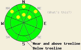
Both above and below treeline, avalanche danger is LOW with pockets of MODERATE avalanche danger on NW-N-NE aspects on slopes 35 degrees and steeper due to the presence of persistent slabs in some areas. Expect to find localized areas of instability within large surrounding areas of stable snow. |
|
|
|
High pressure is building over the forecast area. Cloud cover from the past several days will give way to sunny skies today and continued warming air temperatures. Ridgetop winds remain out of the northeast this morning and will increase to light to moderate in speed today. A further increase in northeast wind speed is forecast to occur tonight. Remote sensors are reporting air temperatures this morning in the upper teens to low 20s this morning for areas above 8,000'. Maximum daytime air temperatures are forecast to warm into the mid 20s to mid 30s today for areas above 7,000'.
Observations made yesterday continued to show a trend of localized areas of instability interspersed within greater areas of stable snowpack conditions across the forecast area. Observations made yesterday on Carpenter Ridge (Independence Lake area) and on the Sierra Crest at the top of the Deep Creek drainage both indicated stable snowpack conditions (photos, videos, pit profiles, more info).
At the same time, ongoing unstable snowpack conditions were observed in the Mount Rose area on the 10,005' subpeak on the E ridge of Mount Rose proper. In this area widespread skier triggered collapsing was observed both above and below treeline on the NE aspect of the subpeak between 8,100' and 9,975' (more info). This matched well with similar observations of skier triggered collapsing in similar terrain on nearby Tamarack Peak on Thursday (more info).
Yesterday on Powderhouse Peak (Luther Pass area) unstable near crust facet layers were observed around melt-freeze and rain crusts that exist just below the base of the recent storm snow. Snowpit tests targeting propagation potential of the facets below the rain crust that formed out of the Jan 24-26 rainfall event indicated that propagation along this weak layer was likely, but that triggering weak layer collapse remained difficult yesterday due to the softness of the overlying slab (video, pit profile, more info).
Avalanche Problem #1: Persistent Slabs
In some but not all locations around the forecast area, weak near crust faceted snow crystals have developed above and below crust layers that exist just below the base of the recent storm snow. As settlement and strengthening of the storm snow has occurred, the area of greatest relative weakness within the upper snowpack has shifted down to these facet layers. As the storm snow continues to settle and gain strength this problem could become more widespread in areas where these faceted weak layers exist. Over the past three days, these layers have been observed on N-NE aspects both above and below treeline between 7,600' and 10,000' in the Pole Creek, Luther Pass, and Mount Rose areas. Human triggered slab avalanches remain possible today in areas where weak near crust facet layers exist.
Taking the time to dig into the snowpack and look for the presence or absence of this weak layer maybe the only way to determine snowpack stability at a specific location today. This will become more important if other more obvious signs of instability such as collapsing and whumphing are not observed. Keep in mind that instability may actually be increasing in some areas over what was observed since Wednesday as the recent storm snow becomes a more cohesive slab, especially in areas that were wind protected during the storm cycle.
Avalanche Problem #2: Loose Wet Avalanches
With March level solar radiation unobstructed by cloud cover today, areas of natural and human triggered loose wet avalanches could occur. For the most part, roller ball activity is expected as snow falls off of rocks and trees. In a few areas, small amounts of snow may become entrained as loose wet snow avalanches. This is expected mainly below 8,500' on E-SE-S-SW-W aspects today. Widespread roller ball activity is likely today, actual loose wet snow avalanches are expected to be isolated.
Both above and below treeline, avalanche danger is LOW with pockets of MODERATE avalanche danger on NW-N-NE aspects on slopes 35 degrees and steeper due to the presence of persistent slabs in some areas. Expect to find localized areas of instability within large surrounding areas of stable snow.
| 0600 temperature: | 18 to 23 deg. F. |
| Max. temperature in the last 24 hours: | 27 to 36 deg. F. |
| Average wind direction during the last 24 hours: | Northeast |
| Average wind speed during the last 24 hours: | 12 mph |
| Maximum wind gust in the last 24 hours: | 33 mph |
| New snowfall in the last 24 hours: | 0 to trace inches |
| Total snow depth: | 66 to 92 inches |
For 7000-8000 ft: |
|||
| Saturday: | Saturday Night: | Sunday: | |
| Weather: | Sunny skies. | Clear skies. | Sunny skies. |
| Temperatures: | 28 to 35 deg. F. | 15 to 23 deg. F. | 39 to 46 deg. F. |
| Wind direction: | NE | NE to E | E |
| Wind speed: | 10 to 15 mph with gusts to 25 mph. | 10 to 15 mph, increasing to 15 to 20 mph with gusts to 30 mph after midnight. | 20 to 25 mph with gusts to 35 mph in the morning, becoming light. |
| Expected snowfall: | O in. | O in. | O in. |
For 8000-9000 ft: |
|||
| Saturday: | Saturday Night: | Sunday: | |
| Weather: | Sunny skies. | Clear skies. | Sunny skies. |
| Temperatures: | 24 to 31 deg. F. | 17 to 23 deg. F. | 41 to 47 deg. F. |
| Wind direction: | NE | NE | NE |
| Wind speed: | 15 to 25 mph with gusts to 35 mph. | 15 to 20 mph with gusts to 30 mph, increasing to 25 to 30 mph with gusts to 45 mph after midnight. | 25 to 30 mph with gusts to 45 mph in the morning, becoming light. |
| Expected snowfall: | O in. | O in. | O in. |


This website is owned and maintained by the non-profit arm of the Sierra Avalanche Center. Some of the content is updated by the USDA avalanche forecasters including the forecasts and some observational data. The USDA is not responsible for any advertising, fund-raising events/information, or sponsorship information, or other content not related to the forecasts and the data pertaining to the forecasts.

