In partnership with: 
|
March 11, 2013 at 7:00 am |
|
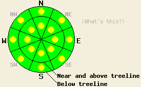
Both above and below treeline, areas of MODERATE avalanche danger exist on all aspects on slopes 35 degrees and steeper due to a combination of persistent slabs, wind slabs, and wet snow instabilities in some areas. Human triggered avalanches remian possible today. Expect to find areas of instability within large surrounding areas of stable snow. |
|
|
|
The high pressure ridge over the forecast area should keep the weather dry and mostly clear for the next several days. A few high thin clouds may develop over the region today and tonight. The forecast calls for day time highs to gradually warm up from day to day. For today and tomorrow expect daytime highs in the mid to upper 40's above 7000 ft. The winds should remain light and should begin shifting towards the west and southwest.
Yesterday a skier triggered avalanche occurred on Schallenberger Ridge on a N facing slope near 7200 ft (photos, more info). The avalanche failed within the recent snow as 4 inch wind slab broke away from the snow below it. This slide then propagated about 60 ft across the slope into an area where the wind slab measured closer to 1 ft in depth. This slide did not entrain any people. Along the Sierra Crest between Mt. Lincoln and Anderson Peak and near Frog Lake on Carson Pass (photos, videos, more info) some new firm wind slabs that did not extend very far away from the ridgelines had formed on the SW-W aspects. Tests on these new wind slabs in the Carson Pass area did indicate that fractures could travel along the base of the wind slabs. On the sheltered N-NE aspects soft snow still existed and tests in these areas did not reveal significant signs of instability. The NE winds had scoured the exposed N-NE-E aspects. A skier in Cascade Canyon reported a "few small wind slabs on top of a crust in limited areas" near ridgelines on higher elevation N aspects. Near 7,700 ft above Cascade Falls, the party triggered two large whumphs on a NE aspect.
Avalanche Problem #1: Wind Slabs
Firm wind slabs exist on the near and above treeline SE-S-SW-W-NW aspects and some older wind slabs may still exist on the N-NE aspects. Human triggered avalanches involving these wind slabs will remain possible today. These slabs should remain limited to areas near ridgelines where the most wind loading has occurred. Sun and warm temperatures could help make it easier to trigger these wind slabs today.
Avalanche Problem #2: Persistent Slabs
As the recent snow has continued to consolidate it has become more slab like. In some areas these soft slabs rest on top of crusts with persistent weak layers of sugary snow (facets) near those crusts. In other areas either this persistent weak layer does not exist, or the NE winds have scoured much of the soft slab away. This combination of recent snow with increasing slab characteristics above a weak layer represents two of the ingredients necessary for an avalanche. All that is missing is the right trigger on the right slope. Human triggered avalanches will remain will remain possible on NW-N-NE aspects where a soft slab of recent snow exists on top of a persistent weak layer.
Digging into the snowpack represents one of the best ways to determine if this weak layer exists below the recent snow. In some areas other more obvious signs of instability such as collapsing and whumphing may exist, and in other areas these obvious clues may not exist. As the recent snow grows more cohesive and the weak snow remains weak, instability may actually increase in some areas.
Avalanche Problem #3: Wet Avalanches
The combination of warm temperatures at all elevations and March sunshine will allow wet snow instabilities to form today. Natural and human triggered loose wet roller balls, pinwheels, and point releases should comprise most of the wet snow instabilities. It is not impossible that a wet slab avalanche could occur today on the most sun-exposed slopes where significant recent snow exists. This warming could also make the wind slabs more fragile in some areas. The sun-exposed SE-S-SW aspects represent the most likely places for wet snow instabilities to form. Some wet snow instabilities could also form on E and W aspects.
Both above and below treeline, areas of MODERATE avalanche danger exist on all aspects on slopes 35 degrees and steeper due to a combination of persistent slabs, wind slabs, and wet snow instabilities in some areas. Human triggered avalanches remian possible today. Expect to find areas of instability within large surrounding areas of stable snow.
| 0600 temperature: | 36-40 deg. F. |
| Max. temperature in the last 24 hours: | 38-48 deg. F. |
| Average wind direction during the last 24 hours: | Northeast |
| Average wind speed during the last 24 hours: | 15 mph |
| Maximum wind gust in the last 24 hours: | 43 mph |
| New snowfall in the last 24 hours: | O inches |
| Total snow depth: | 62-91 inches |
For 7000-8000 ft: |
|||
| Monday: | Monday Night: | Tuesday: | |
| Weather: | Mostly sunny | Clear becoming partly cloudy | Sunny |
| Temperatures: | 42-49 deg. F. | 21-28 deg. F. | 44-51 deg. F. |
| Wind direction: | Variable | Variable | Southwest |
| Wind speed: | Light | Light | 2-10 mph |
| Expected snowfall: | O in. | O in. | O in. |
For 8000-9000 ft: |
|||
| Monday: | Monday Night: | Tuesday: | |
| Weather: | Mostly sunny | Clear becoming partly cloudy | Sunny |
| Temperatures: | 42-48 deg. F. | 23-30 deg. F. | 39-49 deg. F. |
| Wind direction: | West | Variable | Southwest |
| Wind speed: | 10-15 mph in the morning becoming light during the day | Light | 10-15 mph with gusts to 25 mph |
| Expected snowfall: | O in. | O in. | O in. |


This website is owned and maintained by the non-profit arm of the Sierra Avalanche Center. Some of the content is updated by the USDA avalanche forecasters including the forecasts and some observational data. The USDA is not responsible for any advertising, fund-raising events/information, or sponsorship information, or other content not related to the forecasts and the data pertaining to the forecasts.

