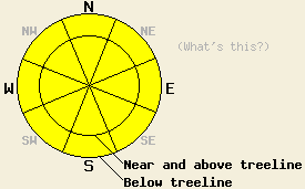
This Avalanche Advisory was published on March 14, 2013:

|
March 14, 2013 at 6:53 am |
|
MODERATE avalanche danger will exist today on all aspects and at all elevations on slopes 35 degrees and steeper. This is due to wet snow instability on all aspects and the possibility of isolated, lingering persistent slabs above 8,000' on NW-N-NE aspects. |
|
|
|
Forecast Discussion:
Record high temperatures for the date were set yesterday. Another very warm day is expected today with record high air temperatures once again possible. Warm air left over from yesterday aided by some cloud cover last night has air temperatures this morning above 8,000' in the low to mid 40s. This is about 5 degrees warmer than 24 hours ago. Maximum daytime air temperatures above 7,000' are forecast to warm into the mid 40s to low 60s today. Ridgetop winds remain moderate in speed out of the southwest this morning. Southwest winds will continue through tomorrow, decreasing to light to moderate in speed tonight.
Observations were made yesterday on Schallenberger Ridge (Donner Summit area) at the site of the skier triggered persistent slab avalanche on Sunday March 10. The persistent near crust facet layer that was the failure layer in this avalanche showed significant improvements in strength and stability. The facet layer was noted to have become moist and much less sugary, easily forming into a snowball. Snowpit tests indicated that the change in the weak layer had changed the propagation potential to unlikely (video, pit profile, more info). This observation on a N aspect at 7,230' and observations from Tuesday on Silver Peak (Pole Creek area) on a N aspect at 7,960' (video, pit profile, more info) both indicate that for areas below 8,000', significant improvements in persistent weak layer stability have occurred. Persistent weak layer stability above 8,000' remains in question.
Wet snow became widespread on all aspects yesterday by noon. Large human triggered roller balls were common, even on full shade north aspects below 8,000'.
Avalanche Problem #1: Loose Wet and Wet Slab Avalanches
Air temperatures are already well above freezing in the pre dawn hours this morning. High level cloud cover overnight combined with the warm air temperatures has limited snow surface refreeze. Wet snow instability is expected to form quickly today and spread to all aspects. Natural and human triggered loose wet roller balls, pinwheels, and loose wet avalanches are expected to represent the majority of wet snow instability today. Human triggered loose wet avalanches large enough to bury a person are possible today. An isolated wet slab avalanche could also occur today on slopes that hold a significant amount of recent storm snow that is still in a transitional process.
Avalanche Problem #2: Persistent Slabs
Lingering instability associated with persistent slabs remains an ongoing concern for NW-N-NE aspects above 8,000'. Areas where the recent storm snow is a cohesive slab sitting on top of a crust and a persistent weak layer of sugary facets remain suspect. In many areas either this persistent weak layer does not exist, the weak layer is not continuous, or the overlying slab has been removed by scouring from NE winds. Isolated human triggered avalanches remain possible today on NW-N-NE aspects where a slab of recent storm snow exists on top of a persistent weak layer of near crust facets. Obvious signs of instability such as collapsing and whumphing are indications that persistent slabs exist in the immediate area and are unstable. Digging into the snowpack is necessary to determine if this weak layer exists and remains reactive below the recent storm snow when obvious signs of instability are absent.
The bottom line:
MODERATE avalanche danger will exist today on all aspects and at all elevations on slopes 35 degrees and steeper. This is due to wet snow instability on all aspects and the possibility of isolated, lingering persistent slabs above 8,000' on NW-N-NE aspects.
Weather Observations from along the Sierra Crest between 8200 ft and 8800 ft:
| 0600 temperature: | 41 to 46 deg. F. |
| Max. temperature in the last 24 hours: | 50 to 59 deg. F. |
| Average wind direction during the last 24 hours: | Southwest |
| Average wind speed during the last 24 hours: | 22 mph |
| Maximum wind gust in the last 24 hours: | 35 mph |
| New snowfall in the last 24 hours: | O inches |
| Total snow depth: | 55 to 86 inches |
Two-Day Mountain Weather Forecast - Produced in partnership with the Reno NWS
For 7000-8000 ft: |
|||
| Thursday: | Thursday Night: | Friday: | |
| Weather: | Partly cloudy skies, becoming mostly cloudy. | Mostly cloudy skies, becoming partly cloudy. | Mostly cloudy skies. |
| Temperatures: | 55 to 61 deg. F. | 32 to 38 deg. F. | 51 to 57 deg. F. |
| Wind direction: | SW | SW | SW |
| Wind speed: | 15 to 20 mph with gusts to 30 mph. | 10 to 15 mph. | 10 to 15 mph. Gusts up to 25 mph in the afternoon. |
| Expected snowfall: | O in. | O in. | O in. |
For 8000-9000 ft: |
|||
| Thursday: | Thursday Night: | Friday: | |
| Weather: | Partly cloudy skies, becoming mostly cloudy. | Mostly cloudy skies, becoming partly cloudy. | Mostly cloudy skies. |
| Temperatures: | 45 to 52 deg. F. | 31 to 38 deg. F. | 41 to 48 deg. F. |
| Wind direction: | SW | SW | SW |
| Wind speed: | 25 to 35 mph. Gusts to 50 mph decreasing to 40 mph in the afternoon. | 15 to 25 mph with gusts to 35 mph. | 15 to 25 mph with gusts to 35 mph. |
| Expected snowfall: | O in. | O in. | O in. |


