In partnership with: 
|
March 17, 2013 at 7:00 am |
|
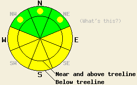
This morning the avalanche danger is LOW for all elevations and aspects. MODERATE avalanche danger may form on the E-SE-S-SW-W aspects in both above and below treeline terrain on slopes steeper than 35 degrees due to daytime warming. Some pockets of MODERATE danger could also form on the below treeline NW-N-NE aspects. Human triggered wet snow avalanches will become possible. |
|
|
|
The winds increased overnight due to a low pressure north of the area and a cold front east of the area. As these features continue to move away from the region during the next 24 hours, the winds should decrease. The forecast calls for strong west winds today and light west winds by tomorrow. The high pressure ridge parked over the area should keep the weather mostly clear and sunny. Temperatures should continue to gradually cool off over the next 24 hours with daytime highs in the 40's today and tomorrow above 7000 ft. A few areas could still reach into the low 50's today.
Observations in the Mt. Rose area yesterday afternoon revealed soft wet snow more than 3 ft. deep on some sun-exposed east and southeast aspects up to at least 9000 ft. Around 3pm a large skier triggered wet snow avalanche occurred on a steep east facing aspect. This slide started as a point release and ended up entraining the entire layer of wet snow by the time it came to a rest. At this time observations near the Fireplug on lower angle slopes indicated that a person could sink up to his/her waist in wet snow on these aspects. On the more south facing and southwest facing aspects in the fireplug area, only 6-8 inches of wet snow existed on top of a more supportable layer of consolidated melt-freeze snow. A 1 inch thick variable melt-freeze crust had formed on the N-NE aspects on the other side of the Fireplug Ridge. This crust remained frozen all day yesterday. Below this crust between 8200 and 9300 ft, the snow remained cold and dry and the March 6 facet layers still existed. Tests performed in an area where whumphing was observed last week indicated that fracture propagation in these layers has become unlikely.
Avalanche Problem #1: Wet Snow Avalanches
Clear skies and overnight temperatures below freezing in most areas should have allowed the snowpack to begin refreezing last night. As the sun comes up and the temperatures warm back up today this overnight refreeze will start to melt on the sun-exposed E-SE-S-SW-W aspects. This warming and melting will weaken the snowpack and allow wet snow instabilities to form again today. Human-triggered roller balls, pin wheels, and point releases should comprise most of these wet snow instabilities, but wet slab avalanches are not impossible. In areas where last night's refreeze did not penetrate as deeply or where it melts away today, these wet snow instabilities could entrain large amounts of snow especially on the E aspects where less pervasive melt-freeze cycles have occurred this winter. The largest and most widespread wet snow instabilities should form on the most sun-exposed E-SE-S-SW-W aspects.
Something to remember: Persistent Slabs
Data collected over the last several days indicates triggering a persistent slab avalanche has become unlikely. In many areas, the warm temperatures and water percolating through the snowpack have begun to change the sugary snow that comprises these weak layers into rounded snow grains that can form bonds with one another. In some isolated areas tests still show that in the unlikely event that the persistent weak layers do break, the resulting fracture could still travel through these layers. Whether or not these layers will support the additional snow load expected to arrive next week or they will fail and allow a persistent deep slab avalanche cycle to occur will depend on both how much they change before the storm and how widespread those changes are.
This morning the avalanche danger is LOW for all elevations and aspects. MODERATE avalanche danger may form on the E-SE-S-SW-W aspects in both above and below treeline terrain on slopes steeper than 35 degrees due to daytime warming. Some pockets of MODERATE danger could also form on the below treeline NW-N-NE aspects. Human triggered wet snow avalanches will become possible.
| 0600 temperature: | 24-31 deg. F. |
| Max. temperature in the last 24 hours: | 39-49 deg. F. |
| Average wind direction during the last 24 hours: | West |
| Average wind speed during the last 24 hours: | 15-30 mph |
| Maximum wind gust in the last 24 hours: | 71 mph |
| New snowfall in the last 24 hours: | O inches |
| Total snow depth: | 52-82 inches |
For 7000-8000 ft: |
|||
| Sunday: | Sunday Night: | Monday: | |
| Weather: | Sunny | Clear becoming partly cloudy | Partly cloudy |
| Temperatures: | 44-52 deg. F. | 21-28 deg. F. | 42-49 deg. F. |
| Wind direction: | West | West shifting to the southwest after midnight | West |
| Wind speed: | 20-25 mph with gusts to 45 mph decreasing to 35 mph in the afternoon | 20-25 mph with gusts to 35 mph decreasing to 10-15 mph after midnight | 10-15 mph in the morning decreasing in the afternoon |
| Expected snowfall: | O in. | O in. | O in. |
For 8000-9000 ft: |
|||
| Sunday: | Sunday Night: | Monday: | |
| Weather: | Sunny | Clear becoming partly cloudy | Partly cloudy |
| Temperatures: | 43-51 deg. F. | 21-28 deg. F. | 41-47 deg. F. |
| Wind direction: | West | West | West |
| Wind speed: | 30-40 mph with gusts to 60 mph decreasing to 50 mph in the afternoon | 25-30 mph with gusts to 40 mph decreasing to 15-20 mph with gusts to 30 mph after midnight | 15-20 mph with gusts to 30 mph |
| Expected snowfall: | O in. | O in. | O in. |


This website is owned and maintained by the non-profit arm of the Sierra Avalanche Center. Some of the content is updated by the USDA avalanche forecasters including the forecasts and some observational data. The USDA is not responsible for any advertising, fund-raising events/information, or sponsorship information, or other content not related to the forecasts and the data pertaining to the forecasts.

